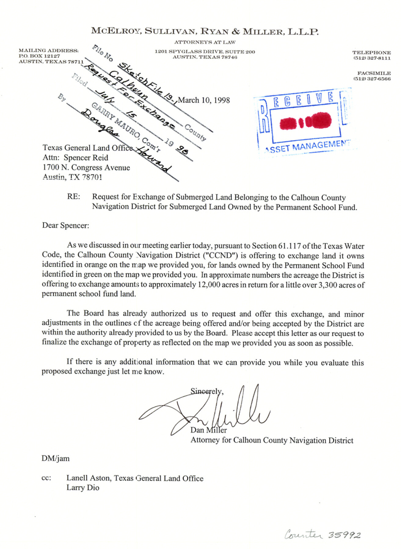
Calhoun County Sketch File 19
[Various instruments regarding the exchange of land between Calhoun County Navigation District and the State of Texas submerged land owned by the PSF]
-
Map/Doc
35992
-
Collection
General Map Collection
-
Object Dates
1998/7/15 (File Date)
1998 (Creation Date)
-
Counties
Calhoun
-
Subjects
Surveying Sketch File
-
Height x Width
11.1 x 8.1 inches
28.2 x 20.6 cm
-
Medium
paper, photocopy
-
Features
FM 2717
Lighthouse Cove
Grass Island
Blackberry Island
Port O'Connor
Powderhorn Lake
Highway 316
Old Town Lake
Highway 2760
Magnolia Beach
Bayucos Island
Cox Bay
Alamo Beach
Chocolate Bay
Port Lavaca
FM 1090
Calhoun County Airport
FM 2433
Highway 238
FM 1289
Huisache Cove
Gulf of Mexico
Matagorda Island
McHenry Bayou
Saluria Bayou
Matagorda Peninsula
Intracoastal Canal
Barroom Bay Bayou
Lavaca Bay
Cox Creek Lake
Matagorda Bay
Point Comfort
FM 1593
Ship Channel
Broad Bayou
Boggy Bayou
Ship Channel Jetties
Farwell Island
Barroom Bay
Part of: General Map Collection
Coleman County Working Sketch 7

Print $20.00
- Digital $50.00
Coleman County Working Sketch 7
1942
Size 38.0 x 47.8 inches
Map/Doc 68073
[Beaumont, Sour Lake and Western Ry. Right of Way and Alignment - Frisco]
![64122, [Beaumont, Sour Lake and Western Ry. Right of Way and Alignment - Frisco], General Map Collection](https://historictexasmaps.com/wmedia_w700/maps/64122.tif.jpg)
Print $20.00
- Digital $50.00
[Beaumont, Sour Lake and Western Ry. Right of Way and Alignment - Frisco]
1910
Size 19.8 x 45.9 inches
Map/Doc 64122
Henderson County Rolled Sketch 13

Print $20.00
- Digital $50.00
Henderson County Rolled Sketch 13
1987
Size 25.3 x 21.0 inches
Map/Doc 6205
Flight Mission No. BQY-4M, Frame 38, Harris County

Print $20.00
- Digital $50.00
Flight Mission No. BQY-4M, Frame 38, Harris County
1953
Size 18.6 x 22.4 inches
Map/Doc 85253
Edwards County Working Sketch 56

Print $20.00
- Digital $50.00
Edwards County Working Sketch 56
1952
Size 23.6 x 35.7 inches
Map/Doc 68932
Marble Falls City, Burnet County, Texas

Print $20.00
- Digital $50.00
Marble Falls City, Burnet County, Texas
1890
Size 26.6 x 20.5 inches
Map/Doc 4830
Matagorda County Sketch File 28

Print $6.00
- Digital $50.00
Matagorda County Sketch File 28
1909
Size 14.2 x 8.8 inches
Map/Doc 30812
Jack County Sketch File 14 1/2

Print $4.00
- Digital $50.00
Jack County Sketch File 14 1/2
1876
Size 8.5 x 12.7 inches
Map/Doc 27543

Atascosa County Working Sketch 3

Print $20.00
- Digital $50.00
Atascosa County Working Sketch 3
1912
Size 26.3 x 13.2 inches
Map/Doc 67198
Schleicher County Working Sketch 25

Print $20.00
- Digital $50.00
Schleicher County Working Sketch 25
1958
Size 29.2 x 13.2 inches
Map/Doc 63827
Shackelford County Rolled Sketch 2

Print $40.00
- Digital $50.00
Shackelford County Rolled Sketch 2
Size 18.9 x 51.9 inches
Map/Doc 75935
You may also like
Frio County Sketch File 2a

Print $6.00
- Digital $50.00
Frio County Sketch File 2a
1861
Size 16.0 x 11.0 inches
Map/Doc 23107
Brewster County Working Sketch 29

Print $20.00
- Digital $50.00
Brewster County Working Sketch 29
1941
Size 19.1 x 31.2 inches
Map/Doc 67563
Presidio County Boundary File 1a

Print $80.00
- Digital $50.00
Presidio County Boundary File 1a
Size 50.2 x 14.9 inches
Map/Doc 58052
Bastrop County Working Sketch 16

Print $20.00
- Digital $50.00
Bastrop County Working Sketch 16
1998
Size 39.2 x 34.1 inches
Map/Doc 67316
Brewster County Rolled Sketch 114

Print $20.00
- Digital $50.00
Brewster County Rolled Sketch 114
1964
Size 11.7 x 18.3 inches
Map/Doc 5276
Duval County Sketch File 83

Print $20.00
- Digital $50.00
Duval County Sketch File 83
1933
Size 13.7 x 8.8 inches
Map/Doc 21521
Flight Mission No. CGI-3G, Frame 12, Cameron County

Print $20.00
- Digital $50.00
Flight Mission No. CGI-3G, Frame 12, Cameron County
1950
Size 19.3 x 19.0 inches
Map/Doc 84531
Wise County Working Sketch 17

Print $20.00
- Digital $50.00
Wise County Working Sketch 17
1972
Size 29.9 x 25.0 inches
Map/Doc 72631
San Jacinto County Working Sketch 42b

Print $3.00
- Digital $50.00
San Jacinto County Working Sketch 42b
1979
Size 10.7 x 14.4 inches
Map/Doc 63756
Refugio County Sketch File 8b

Print $4.00
- Digital $50.00
Refugio County Sketch File 8b
1876
Size 8.5 x 10.5 inches
Map/Doc 35254
Duval County Sketch File 79

Print $46.00
- Digital $50.00
Duval County Sketch File 79
1925
Size 14.3 x 9.1 inches
Map/Doc 21469
Harris County Rolled Sketch R & B

Print $40.00
- Digital $50.00
Harris County Rolled Sketch R & B
1901
Size 63.8 x 30.0 inches
Map/Doc 8344