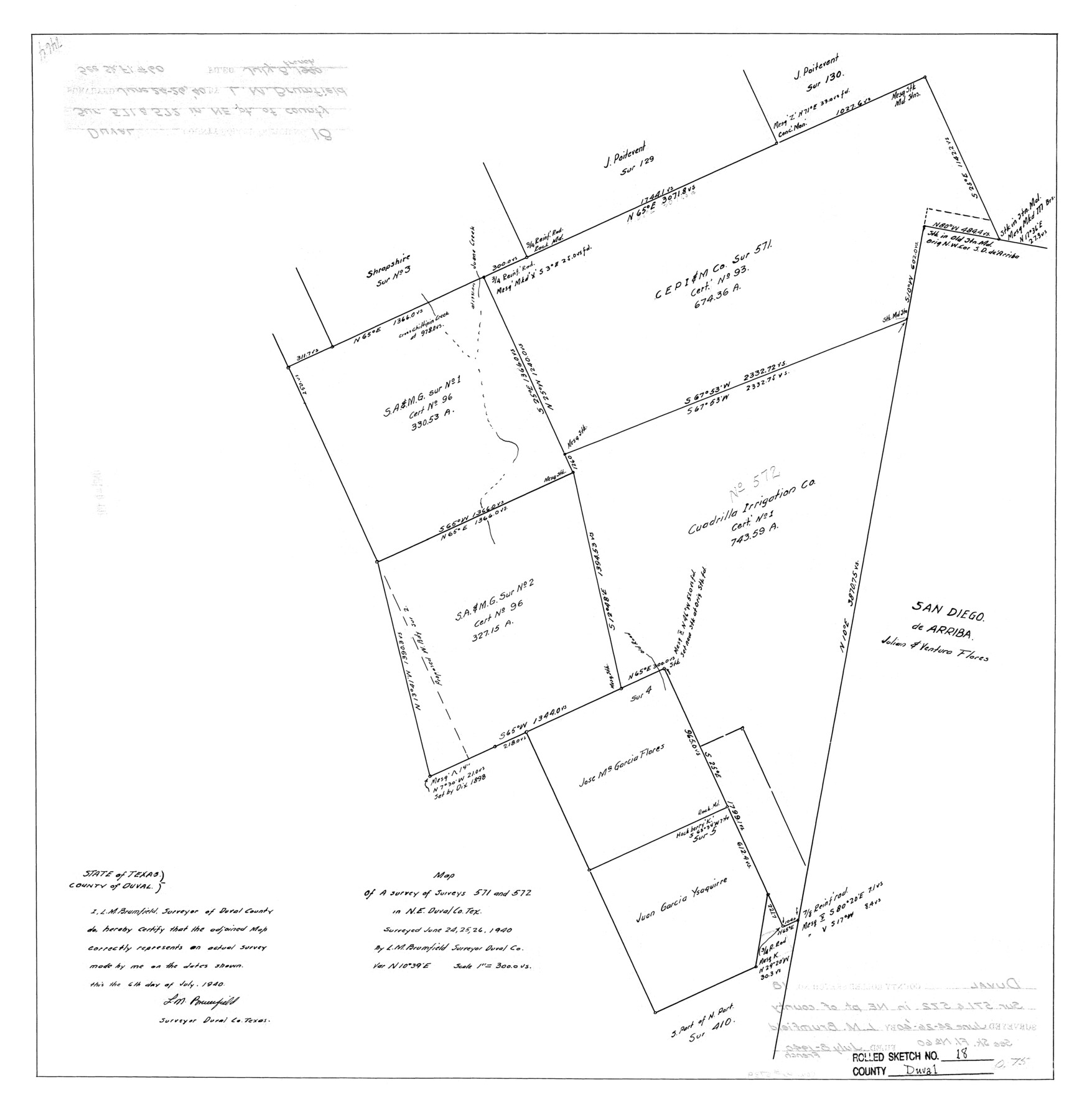
Duval County Rolled Sketch 18
Map of a survey of surveys 571 and 572 in NE Duval Co., Tex.
-
Map/Doc
5739
-
Collection
General Map Collection
-
Object Dates
1940/7/6 (Creation Date)
1940/7/8 (File Date)
-
People and Organizations
L.M. Brumfield (Surveyor/Engineer)
-
Counties
Duval
-
Subjects
Surveying Rolled Sketch
-
Height x Width
23.7 x 23.0 inches
60.2 x 58.4 cm
-
Scale
1" = 300 varas
Part of: General Map Collection
Brazos River, Harlem-Imperial Farms Project

Print $20.00
- Digital $50.00
Brazos River, Harlem-Imperial Farms Project
1930
Size 28.3 x 25.5 inches
Map/Doc 69678
Flight Mission No. DQO-8K, Frame 77, Galveston County

Print $20.00
- Digital $50.00
Flight Mission No. DQO-8K, Frame 77, Galveston County
1952
Size 18.9 x 22.5 inches
Map/Doc 85181
Kent County Working Sketch 12

Print $20.00
- Digital $50.00
Kent County Working Sketch 12
1953
Size 33.8 x 24.3 inches
Map/Doc 70019

Liberty County Working Sketch 51

Print $20.00
- Digital $50.00
Liberty County Working Sketch 51
1955
Size 17.5 x 38.5 inches
Map/Doc 70511
Subdivision Plat of Blue Ridge State Farm Showing 18 Tracts

Print $20.00
- Digital $50.00
Subdivision Plat of Blue Ridge State Farm Showing 18 Tracts
Size 27.0 x 27.4 inches
Map/Doc 62978
Eastland County Working Sketch 59

Print $20.00
- Digital $50.00
Eastland County Working Sketch 59
1987
Size 19.7 x 37.9 inches
Map/Doc 68840
Kinney County Working Sketch 4

Print $20.00
- Digital $50.00
Kinney County Working Sketch 4
1907
Size 21.1 x 21.6 inches
Map/Doc 70186
Hale County Boundary File 7

Print $48.00
- Digital $50.00
Hale County Boundary File 7
Size 25.0 x 18.6 inches
Map/Doc 54075
Map No. 1 - Rio Bravo del Norte section of boundary between the United States & Mexico agreed upon by the Joint Commission under the Treaty of Guadalupe Hidalgo

Print $20.00
- Digital $50.00
Map No. 1 - Rio Bravo del Norte section of boundary between the United States & Mexico agreed upon by the Joint Commission under the Treaty of Guadalupe Hidalgo
1852
Size 18.4 x 27.0 inches
Map/Doc 72866
Blanco County Sketch File 18

Print $4.00
- Digital $50.00
Blanco County Sketch File 18
1877
Size 12.6 x 8.5 inches
Map/Doc 14594
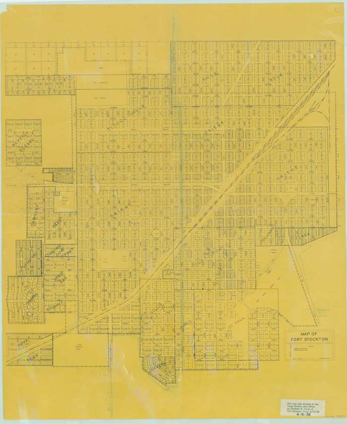
Map of Fort Stockton
Print $20.00
- Digital $50.00
Map of Fort Stockton
Size 22.4 x 18.3 inches
Map/Doc 76870
You may also like
Flight Mission No. CGI-3N, Frame 52, Cameron County

Print $20.00
- Digital $50.00
Flight Mission No. CGI-3N, Frame 52, Cameron County
1954
Size 18.7 x 22.2 inches
Map/Doc 84558
Wheeler County Working Sketch 19

Print $20.00
- Digital $50.00
Wheeler County Working Sketch 19
1986
Size 33.5 x 31.8 inches
Map/Doc 72508
Potter County Sketch File 16

Print $38.00
- Digital $50.00
Potter County Sketch File 16
Size 13.0 x 13.9 inches
Map/Doc 34401
General Highway Map, Henderson County, Texas

Print $20.00
General Highway Map, Henderson County, Texas
1961
Size 24.9 x 18.0 inches
Map/Doc 79517
Presidio County Rolled Sketch 83A

Print $20.00
- Digital $50.00
Presidio County Rolled Sketch 83A
1930
Size 28.2 x 27.6 inches
Map/Doc 7370
Galveston County NRC Article 33.136 Sketch 78

Print $24.00
- Digital $50.00
Galveston County NRC Article 33.136 Sketch 78
2015
Size 36.0 x 24.0 inches
Map/Doc 95129
Flight Mission No. BQR-22K, Frame 35, Brazoria County

Print $20.00
- Digital $50.00
Flight Mission No. BQR-22K, Frame 35, Brazoria County
1953
Size 18.7 x 22.5 inches
Map/Doc 84119
Starr County Sketch File 14

Print $40.00
- Digital $50.00
Starr County Sketch File 14
Size 23.8 x 46.0 inches
Map/Doc 4626
Working Sketch in Eastland, Stephens, and Palo Pinto Co's.

Print $20.00
- Digital $50.00
Working Sketch in Eastland, Stephens, and Palo Pinto Co's.
1919
Size 40.3 x 35.7 inches
Map/Doc 91995
Flight Mission No. CUG-1P, Frame 85, Kleberg County

Print $20.00
- Digital $50.00
Flight Mission No. CUG-1P, Frame 85, Kleberg County
1956
Size 18.6 x 22.2 inches
Map/Doc 86150
Shelby County Working Sketch 22

Print $20.00
- Digital $50.00
Shelby County Working Sketch 22
1981
Size 28.9 x 41.2 inches
Map/Doc 63875
Topographical Map of the Rio Grande, Sheet No. 24

Print $20.00
- Digital $50.00
Topographical Map of the Rio Grande, Sheet No. 24
1912
Map/Doc 89548