Crosby County Rolled Sketch 1A
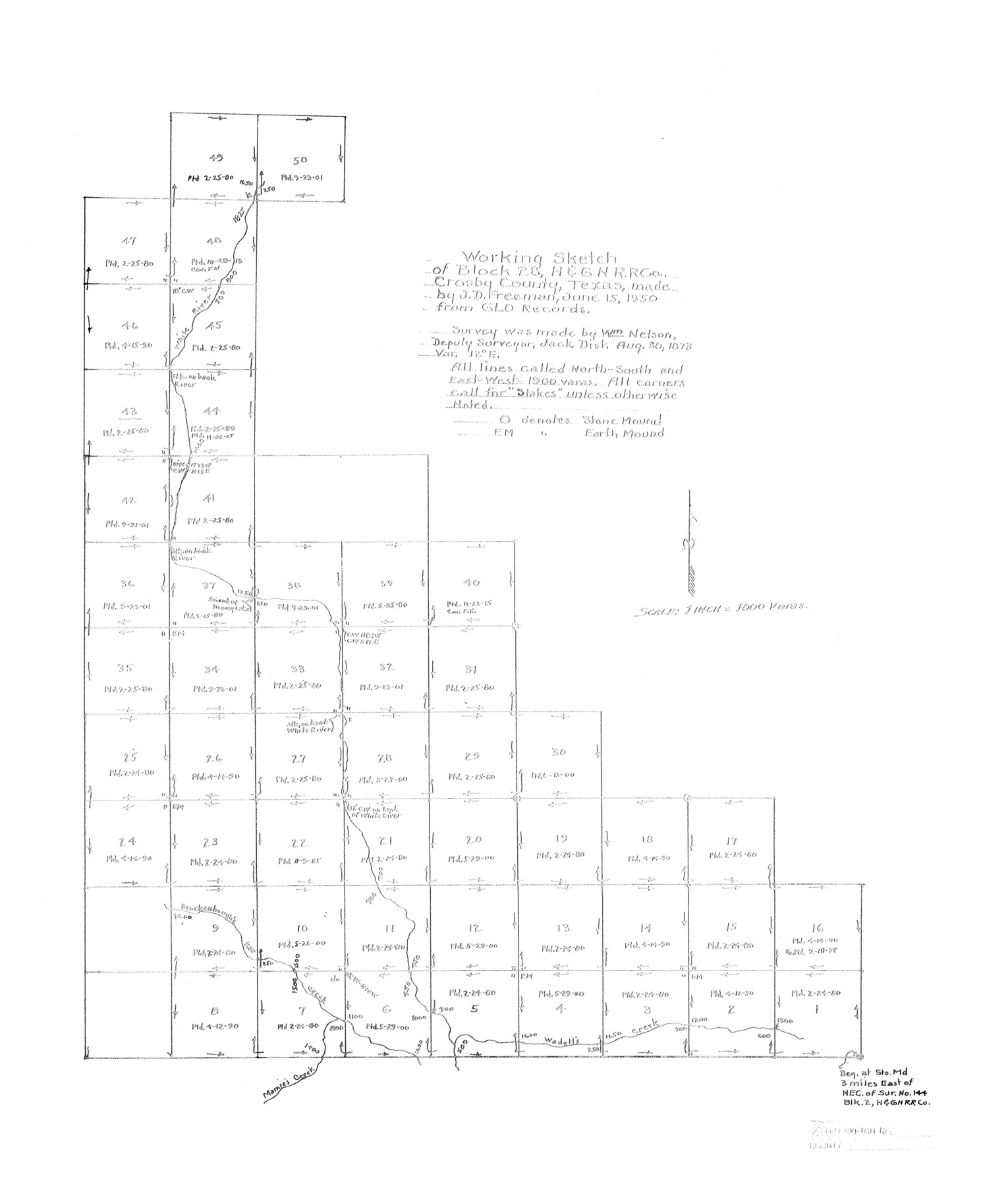
Working sketch of Block 28, H. & G. N. R.R. Co., Crosby County, Texas
-
Map/Doc
5641
-
Collection
General Map Collection
-
Object Dates
1950/6/15 (Creation Date)
1873/8/30 (Survey Date)
-
People and Organizations
J.D. Freeman (Draftsman)
Wm. Nelson (Surveyor/Engineer)
-
Counties
Crosby
-
Subjects
Surveying Rolled Sketch
-
Height x Width
26.1 x 22.2 inches
66.3 x 56.4 cm
-
Medium
paper, photocopy
-
Scale
1" = 1000 varas
Part of: General Map Collection
Anderson County Sketch File 6

Print $4.00
- Digital $50.00
Anderson County Sketch File 6
Size 12.5 x 8.2 inches
Map/Doc 12753
Map of Bell County

Print $40.00
- Digital $50.00
Map of Bell County
1896
Size 48.1 x 54.4 inches
Map/Doc 82066
Bosque County Working Sketch 14

Print $20.00
- Digital $50.00
Bosque County Working Sketch 14
1962
Size 24.1 x 23.3 inches
Map/Doc 67447
Map of Travis County

Print $40.00
- Digital $50.00
Map of Travis County
1894
Size 49.8 x 58.8 inches
Map/Doc 16904
Palo Pinto County Sketch File 20

Print $6.00
- Digital $50.00
Palo Pinto County Sketch File 20
1891
Size 12.5 x 10.9 inches
Map/Doc 33402
Moore County Rolled Sketch 4

Print $20.00
- Digital $50.00
Moore County Rolled Sketch 4
Size 21.1 x 12.1 inches
Map/Doc 6824
Flight Mission No. DQO-2K, Frame 140, Galveston County

Print $20.00
- Digital $50.00
Flight Mission No. DQO-2K, Frame 140, Galveston County
1952
Size 18.8 x 22.5 inches
Map/Doc 85037
Topographical Map of the Rio Grande, Sheet No. 5

Print $20.00
- Digital $50.00
Topographical Map of the Rio Grande, Sheet No. 5
1912
Map/Doc 89529
Gregg County Working Sketch 9

Print $20.00
- Digital $50.00
Gregg County Working Sketch 9
1939
Size 20.3 x 34.8 inches
Map/Doc 63275
Map of Surveys Made for the T&PRR in Martin & Tom Green Counties, Blocks 34-39, Reserve West of the Colorado River

Print $20.00
- Digital $50.00
Map of Surveys Made for the T&PRR in Martin & Tom Green Counties, Blocks 34-39, Reserve West of the Colorado River
1876
Size 41.9 x 43.7 inches
Map/Doc 2226
Wise County Rolled Sketch 4

Print $20.00
- Digital $50.00
Wise County Rolled Sketch 4
1955
Size 20.0 x 13.7 inches
Map/Doc 8278

You may also like
Upton County Rolled Sketch 45

Print $20.00
- Digital $50.00
Upton County Rolled Sketch 45
Size 25.1 x 43.8 inches
Map/Doc 8081
Photo Index of Texas Coast - Sheet 2 of 6

Print $20.00
- Digital $50.00
Photo Index of Texas Coast - Sheet 2 of 6
1954
Size 20.0 x 24.0 inches
Map/Doc 83439
Harris County Sketch File 14

Print $20.00
- Digital $50.00
Harris County Sketch File 14
Size 17.4 x 18.4 inches
Map/Doc 11649
Flight Mission No. DQN-1K, Frame 118, Calhoun County

Print $20.00
- Digital $50.00
Flight Mission No. DQN-1K, Frame 118, Calhoun County
1953
Size 18.5 x 22.2 inches
Map/Doc 84184
General Highway Map, Comanche County, Texas

Print $20.00
General Highway Map, Comanche County, Texas
1961
Size 24.7 x 18.2 inches
Map/Doc 79419
Palo Pinto County Rolled Sketch 11

Print $20.00
- Digital $50.00
Palo Pinto County Rolled Sketch 11
1976
Size 20.5 x 19.9 inches
Map/Doc 7191
Irion County Rolled Sketch 17

Print $20.00
- Digital $50.00
Irion County Rolled Sketch 17
1956
Size 40.5 x 40.2 inches
Map/Doc 9255
Hopkins County Sketch File 2

Print $28.00
- Digital $50.00
Hopkins County Sketch File 2
1845
Size 11.1 x 7.9 inches
Map/Doc 26678
Mills County Sketch File 10 1/2

Print $24.00
- Digital $50.00
Mills County Sketch File 10 1/2
1876
Size 14.4 x 17.6 inches
Map/Doc 31656
Haskell County Boundary File 1

Print $36.00
- Digital $50.00
Haskell County Boundary File 1
Size 8.7 x 9.0 inches
Map/Doc 54518
Sutton County Sketch File 33B

Print $20.00
- Digital $50.00
Sutton County Sketch File 33B
1934
Size 17.1 x 29.5 inches
Map/Doc 12386
Presidio County Working Sketch 146

Print $20.00
- Digital $50.00
Presidio County Working Sketch 146
1989
Size 20.7 x 20.6 inches
Map/Doc 71824