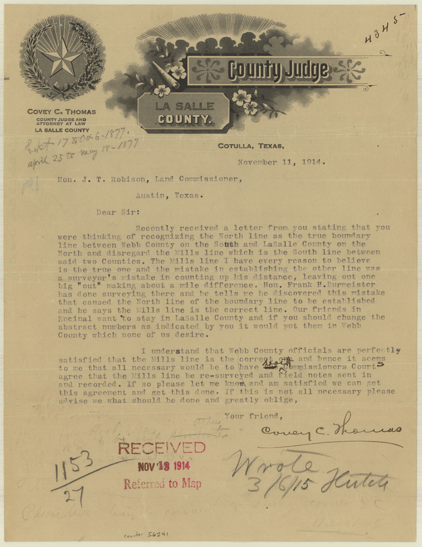
La Salle County Boundary File 2
[Letter regarding La Salle-Webb Boundary line]
-
Map/Doc
56241
-
Collection
General Map Collection
-
Counties
La Salle
-
Subjects
County Boundaries
-
Height x Width
11.1 x 8.6 inches
28.2 x 21.8 cm
Part of: General Map Collection
Atascosa County Sketch File 8

Print $6.00
- Digital $50.00
Atascosa County Sketch File 8
1857
Size 8.7 x 7.7 inches
Map/Doc 13758
Coryell County Working Sketch 23

Print $20.00
- Digital $50.00
Coryell County Working Sketch 23
1977
Size 27.6 x 30.6 inches
Map/Doc 68230
Webb County Working Sketch 85

Print $20.00
- Digital $50.00
Webb County Working Sketch 85
1981
Size 21.1 x 29.0 inches
Map/Doc 72452
Culberson County Rolled Sketch 53

Print $20.00
- Digital $50.00
Culberson County Rolled Sketch 53
1968
Size 36.7 x 47.2 inches
Map/Doc 8756
Dallam County Sketch File 5

Print $22.00
- Digital $50.00
Dallam County Sketch File 5
1880
Size 14.2 x 8.8 inches
Map/Doc 20339
[Map of Upshur County]
![[Map of Upshur County]](https://historictexasmaps.com/wmedia_w700/maps/4651.tif.jpg)
Print $20.00
- Digital $50.00
[Map of Upshur County]
1850
Size 25.2 x 17.8 inches
Map/Doc 4651
Presidio County Working Sketch 76

Print $20.00
- Digital $50.00
Presidio County Working Sketch 76
1963
Size 29.8 x 30.8 inches
Map/Doc 71753
Flight Mission No. DIX-6P, Frame 189, Aransas County

Print $20.00
- Digital $50.00
Flight Mission No. DIX-6P, Frame 189, Aransas County
1956
Size 19.1 x 22.8 inches
Map/Doc 83851
Nueces County Rolled Sketch 4

Print $20.00
- Digital $50.00
Nueces County Rolled Sketch 4
1910
Size 39.8 x 38.5 inches
Map/Doc 9583
Martin County Sketch File 15

Print $4.00
- Digital $50.00
Martin County Sketch File 15
Size 11.9 x 8.3 inches
Map/Doc 30674
El Paso County Rolled Sketch 57B

Print $40.00
- Digital $50.00
El Paso County Rolled Sketch 57B
1984
Size 49.0 x 37.1 inches
Map/Doc 8880
Edwards County Working Sketch 61

Print $20.00
- Digital $50.00
Edwards County Working Sketch 61
1954
Size 21.0 x 40.3 inches
Map/Doc 68937
You may also like
Flight Mission No. DIX-5P, Frame 141, Aransas County

Print $20.00
- Digital $50.00
Flight Mission No. DIX-5P, Frame 141, Aransas County
1956
Size 17.8 x 18.4 inches
Map/Doc 83802
[Texas Boundary Line]
![92080, [Texas Boundary Line], Twichell Survey Records](https://historictexasmaps.com/wmedia_w700/maps/92080-1.tif.jpg)
Print $20.00
- Digital $50.00
[Texas Boundary Line]
Size 21.7 x 12.1 inches
Map/Doc 92080
Walker County Working Sketch 13

Print $20.00
- Digital $50.00
Walker County Working Sketch 13
1950
Size 18.0 x 16.6 inches
Map/Doc 72293
Calhoun County Working Sketch 5

Print $40.00
- Digital $50.00
Calhoun County Working Sketch 5
1941
Size 23.7 x 125.2 inches
Map/Doc 67821
Altita Ranch & Hunter Farm
Print $20.00
- Digital $50.00
Altita Ranch & Hunter Farm
Size 20.2 x 15.6 inches
Map/Doc 492
Harrison County State Real Property Sketch 1

Print $20.00
- Digital $50.00
Harrison County State Real Property Sketch 1
1986
Size 24.2 x 25.4 inches
Map/Doc 61666
Galveston Co., 1891

Print $40.00
- Digital $50.00
Galveston Co., 1891
1891
Size 37.9 x 54.1 inches
Map/Doc 7822
McCulloch County

Print $20.00
- Digital $50.00
McCulloch County
1949
Size 41.0 x 31.1 inches
Map/Doc 77361
Haskell County Rolled Sketch 16

Print $20.00
- Digital $50.00
Haskell County Rolled Sketch 16
1991
Size 45.3 x 39.4 inches
Map/Doc 9148
A New Map of North America

Print $20.00
- Digital $50.00
A New Map of North America
Size 18.5 x 22.2 inches
Map/Doc 95141
United States Population Distribution by County and Territory, per the U.S. Census of 1900

United States Population Distribution by County and Territory, per the U.S. Census of 1900
2025
Size 8.5 x 11.0 inches
Map/Doc 97481
Flight Mission No. DQO-8K, Frame 72, Galveston County

Print $20.00
- Digital $50.00
Flight Mission No. DQO-8K, Frame 72, Galveston County
1952
Size 18.7 x 22.4 inches
Map/Doc 85176