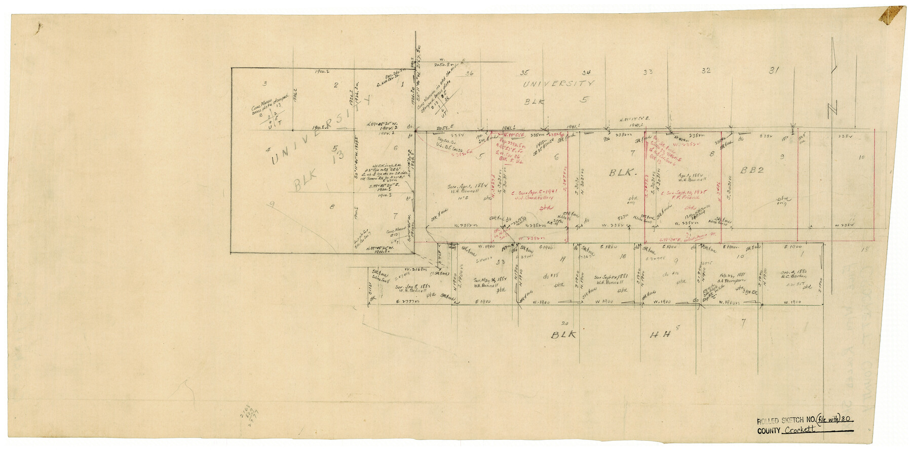
Crockett County Rolled Sketch 80
[Sketch showing University Block 13, Block BB2 and portion of Block HH in Crockett County, Texas]
-
Map/Doc
5620
-
Collection
General Map Collection
-
Counties
Crockett
-
Subjects
Surveying Rolled Sketch
-
Height x Width
14.0 x 28.5 inches
35.6 x 72.4 cm
-
Medium
paper, manuscript
Part of: General Map Collection
Henderson County Working Sketch 4

Print $20.00
- Digital $50.00
Henderson County Working Sketch 4
1918
Size 21.2 x 16.0 inches
Map/Doc 66137
Sherman County Sketch File C

Print $54.00
- Digital $50.00
Sherman County Sketch File C
1918
Size 11.4 x 8.8 inches
Map/Doc 36694
Blanco County Sketch File 31a

Print $4.00
- Digital $50.00
Blanco County Sketch File 31a
1889
Size 8.6 x 14.1 inches
Map/Doc 14631
Flight Mission No. CLL-1N, Frame 195, Willacy County

Print $20.00
- Digital $50.00
Flight Mission No. CLL-1N, Frame 195, Willacy County
1954
Size 18.5 x 22.3 inches
Map/Doc 87065
Upton County Working Sketch 12

Print $40.00
- Digital $50.00
Upton County Working Sketch 12
1937
Size 43.6 x 77.9 inches
Map/Doc 69508
Montague County Working Sketch 19

Print $20.00
- Digital $50.00
Montague County Working Sketch 19
1952
Size 26.4 x 21.5 inches
Map/Doc 71085
Roberts County Sketch File 4

Print $12.00
- Digital $50.00
Roberts County Sketch File 4
1889
Size 8.7 x 7.8 inches
Map/Doc 35306
[Map of Denton County]
![4529, [Map of Denton County], General Map Collection](https://historictexasmaps.com/wmedia_w700/maps/4529-1.tif.jpg)
Print $20.00
- Digital $50.00
[Map of Denton County]
1853
Size 24.5 x 29.1 inches
Map/Doc 4529
Hamilton County Boundary File 7

Print $32.00
- Digital $50.00
Hamilton County Boundary File 7
Size 17.6 x 11.4 inches
Map/Doc 54227
La Salle County Working Sketch 16

Print $20.00
- Digital $50.00
La Salle County Working Sketch 16
1936
Size 26.5 x 16.2 inches
Map/Doc 70317
Flight Mission No. BRA-16M, Frame 53, Jefferson County

Print $20.00
- Digital $50.00
Flight Mission No. BRA-16M, Frame 53, Jefferson County
1953
Size 18.4 x 22.6 inches
Map/Doc 85670
Presidio County Rolled Sketch 131A

Print $40.00
- Digital $50.00
Presidio County Rolled Sketch 131A
1991
Size 37.6 x 49.7 inches
Map/Doc 10713
You may also like
Jefferson County

Print $20.00
- Digital $50.00
Jefferson County
1882
Size 22.8 x 20.0 inches
Map/Doc 3730
Fannin County Boundary File 1

Print $14.00
- Digital $50.00
Fannin County Boundary File 1
Size 13.2 x 8.6 inches
Map/Doc 53272
Map of Tom Green County

Print $20.00
- Digital $50.00
Map of Tom Green County
1892
Size 44.0 x 45.1 inches
Map/Doc 63068
Map showing the Atchison, Topeka and Santa Fe Railroad system, with its connections.

Print $20.00
Map showing the Atchison, Topeka and Santa Fe Railroad system, with its connections.
1883
Size 22.0 x 29.1 inches
Map/Doc 93583
Flight Mission No. CGI-3N, Frame 174, Cameron County

Print $20.00
- Digital $50.00
Flight Mission No. CGI-3N, Frame 174, Cameron County
1954
Size 18.5 x 22.1 inches
Map/Doc 84638
Map of the Western States designed to accompany Smith's Geography for Schools

Print $20.00
- Digital $50.00
Map of the Western States designed to accompany Smith's Geography for Schools
1850
Size 12.2 x 19.1 inches
Map/Doc 93889
Llano County Working Sketch 14

Print $20.00
- Digital $50.00
Llano County Working Sketch 14
1989
Size 14.6 x 34.7 inches
Map/Doc 70632
Montague County Rolled Sketch R

Print $20.00
- Digital $50.00
Montague County Rolled Sketch R
Size 44.3 x 29.8 inches
Map/Doc 6794
Moore County Sketch File 14

Print $4.00
- Digital $50.00
Moore County Sketch File 14
Size 11.2 x 8.8 inches
Map/Doc 31961
Galveston County NRC Article 33.136 Sketch 2

Print $46.00
- Digital $50.00
Galveston County NRC Article 33.136 Sketch 2
2000
Size 23.1 x 34.4 inches
Map/Doc 61565
Map of Cass Co.

Print $20.00
- Digital $50.00
Map of Cass Co.
1862
Size 17.8 x 19.6 inches
Map/Doc 3372
[Map of Santa Fe Route - Atchison, Topeka, and Santa Fe Railroad]
![95866, [Map of Santa Fe Route - Atchison, Topeka, and Santa Fe Railroad], Cobb Digital Map Collection - 1](https://historictexasmaps.com/wmedia_w700/maps/95866.tif.jpg)
Print $40.00
- Digital $50.00
[Map of Santa Fe Route - Atchison, Topeka, and Santa Fe Railroad]
1893
Size 17.4 x 50.0 inches
Map/Doc 95866