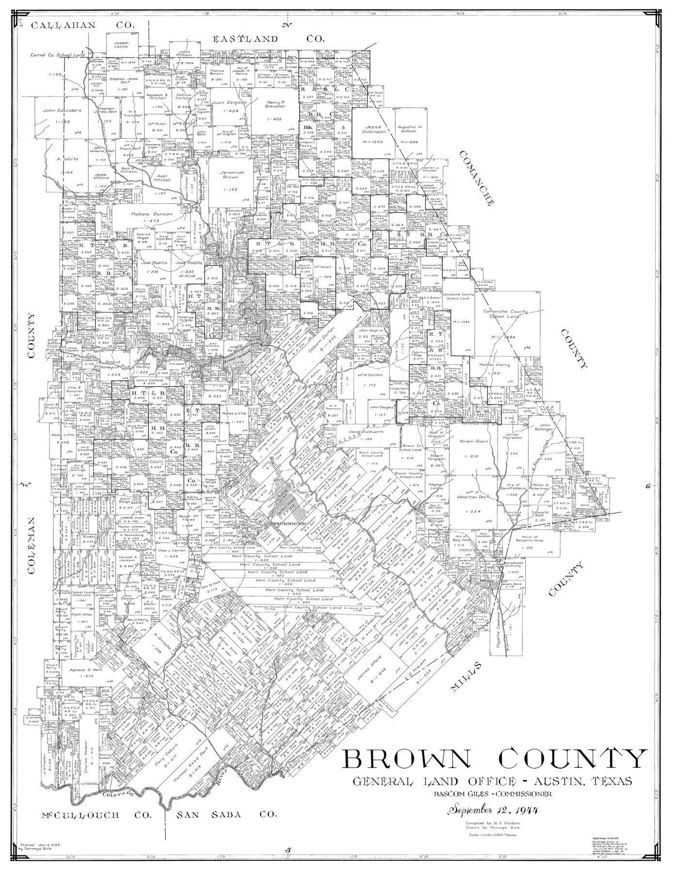
Brown County
-
Map/Doc
77224
-
Collection
General Map Collection
-
Object Dates
1944/9/12 (Creation Date)
-
People and Organizations
Tommye Buie (Draftsman)
R.C. Wisdom (Compiler)
-
Counties
Brown
-
Subjects
County
-
Height x Width
46.8 x 36.1 inches
118.9 x 91.7 cm
Part of: General Map Collection
Reagan County Sketch File 22

Print $6.00
- Digital $50.00
Reagan County Sketch File 22
1939
Size 11.4 x 8.9 inches
Map/Doc 35013
Fort Bend County Sketch File 27

Print $20.00
- Digital $50.00
Fort Bend County Sketch File 27
1910
Size 17.9 x 37.7 inches
Map/Doc 10453
Carta Historica y Arqueologica

Print $20.00
- Digital $50.00
Carta Historica y Arqueologica
Size 26.0 x 34.4 inches
Map/Doc 96806
Duval County Rolled Sketch 47

Print $40.00
- Digital $50.00
Duval County Rolled Sketch 47
1991
Size 35.4 x 48.0 inches
Map/Doc 8824
Starr County Rolled Sketch 8

Print $20.00
- Digital $50.00
Starr County Rolled Sketch 8
Size 21.5 x 29.6 inches
Map/Doc 7796

Pecos County Rolled Sketch 93

Print $40.00
- Digital $50.00
Pecos County Rolled Sketch 93
Size 50.3 x 42.8 inches
Map/Doc 9711
Flight Mission No. CRK-8P, Frame 122, Refugio County

Print $20.00
- Digital $50.00
Flight Mission No. CRK-8P, Frame 122, Refugio County
1956
Size 18.4 x 22.1 inches
Map/Doc 86977
Jeff Davis County Sketch File 25

Print $32.00
- Digital $50.00
Jeff Davis County Sketch File 25
1886
Size 11.3 x 8.5 inches
Map/Doc 27992
Bell County Sketch File 10

Print $4.00
- Digital $50.00
Bell County Sketch File 10
1851
Size 12.7 x 8.4 inches
Map/Doc 14381
Brooks County Working Sketch 3

Print $20.00
- Digital $50.00
Brooks County Working Sketch 3
Size 16.2 x 21.3 inches
Map/Doc 67787
Flight Mission No. DIX-5P, Frame 152, Aransas County

Print $20.00
- Digital $50.00
Flight Mission No. DIX-5P, Frame 152, Aransas County
1956
Size 17.8 x 18.6 inches
Map/Doc 83814
You may also like
Terry County Sketch File 6

Print $8.00
- Digital $50.00
Terry County Sketch File 6
1924
Size 11.2 x 8.7 inches
Map/Doc 38026
Duval County Rolled Sketch WSR

Print $20.00
- Digital $50.00
Duval County Rolled Sketch WSR
1938
Size 39.2 x 26.8 inches
Map/Doc 5772
Cooke County Sketch File 9

Print $6.00
- Digital $50.00
Cooke County Sketch File 9
Size 8.2 x 10.5 inches
Map/Doc 19237
[Worksheets related to the Wilson Strickland survey and vicinity]
![89715, [Vicinity and related to the Wilson Strickland Survey], Twichell Survey Records](https://historictexasmaps.com/wmedia_w700/maps/89715-1.tif.jpg)
Print $20.00
- Digital $50.00
[Worksheets related to the Wilson Strickland survey and vicinity]
Size 34.7 x 43.0 inches
Map/Doc 89715
Flight Mission No. CUG-1P, Frame 165, Kleberg County

Print $20.00
- Digital $50.00
Flight Mission No. CUG-1P, Frame 165, Kleberg County
1956
Size 18.7 x 22.2 inches
Map/Doc 86172
Garza County Sketch File C2

Print $6.00
- Digital $50.00
Garza County Sketch File C2
1900
Size 10.3 x 8.4 inches
Map/Doc 24019
East Part of Blk. No. 1, H. &G. N. R. R. Co. Survey

Print $40.00
- Digital $50.00
East Part of Blk. No. 1, H. &G. N. R. R. Co. Survey
Size 22.7 x 60.6 inches
Map/Doc 89626
Flight Mission No. DQN-2K, Frame 70, Calhoun County

Print $20.00
- Digital $50.00
Flight Mission No. DQN-2K, Frame 70, Calhoun County
1953
Size 18.7 x 22.3 inches
Map/Doc 84262
Kimble County Working Sketch 65

Print $20.00
- Digital $50.00
Kimble County Working Sketch 65
1964
Size 22.1 x 17.0 inches
Map/Doc 70133
Edwards County Rolled Sketch 22

Print $20.00
- Digital $50.00
Edwards County Rolled Sketch 22
1951
Size 46.0 x 25.4 inches
Map/Doc 8845
Map of Encinal County, Texas

Print $20.00
- Digital $50.00
Map of Encinal County, Texas
1879
Size 22.7 x 28.4 inches
Map/Doc 715
Stephens County

Print $20.00
- Digital $50.00
Stephens County
1940
Size 40.3 x 38.9 inches
Map/Doc 77426