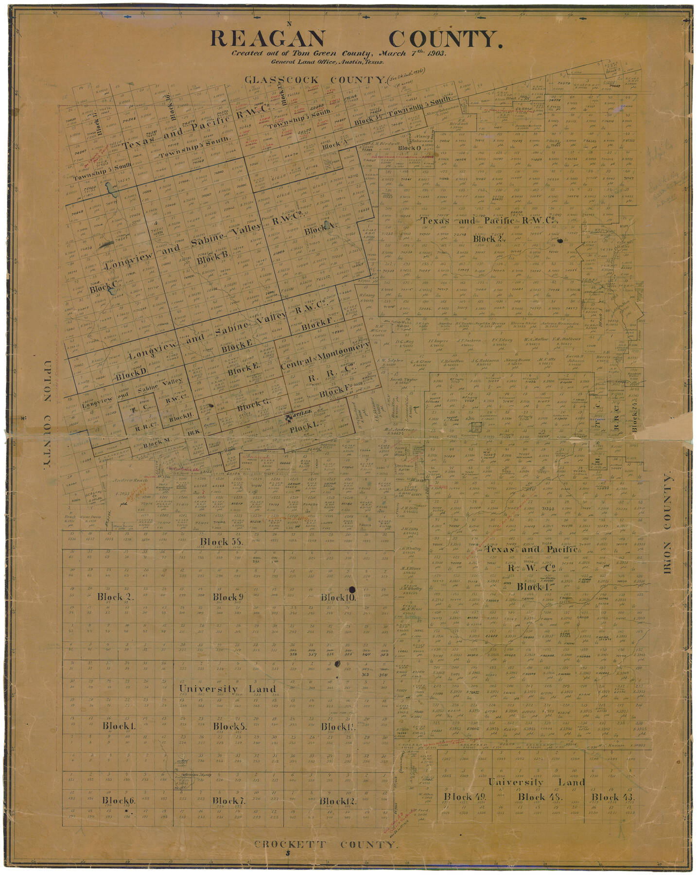
Reagan County
-
Map/Doc
16794
-
Collection
General Map Collection
-
Object Dates
3/7/1903 (Creation Date)
-
People and Organizations
Texas General Land Office (Publisher)
Ed. Schutze (Compiler)
-
Counties
Reagan
-
Subjects
County
-
Height x Width
45.6 x 36.2 inches
115.8 x 92.0 cm
-
Comments
Note on back: "Compiled by E. Schutze evidently about same time of East Tom Green Co. which was in 1892, Legg 5/12/05".
Help Save Texas History - Adopt Me! -
Features
Correll Creek
Stiles
Centralia Station
P&G
Grierson Spring
Concho River
Part of: General Map Collection
Angelina County Working Sketch 22b

Print $20.00
- Digital $50.00
Angelina County Working Sketch 22b
1953
Size 21.5 x 19.6 inches
Map/Doc 67104
Map of Wheeler County

Print $20.00
- Digital $50.00
Map of Wheeler County
1899
Size 40.1 x 32.7 inches
Map/Doc 63120
Menard County Sketch File 25b

Print $6.00
- Digital $50.00
Menard County Sketch File 25b
1936
Size 14.2 x 8.6 inches
Map/Doc 31557
Sutton County Rolled Sketch 57

Print $40.00
- Digital $50.00
Sutton County Rolled Sketch 57
1958
Size 40.1 x 51.1 inches
Map/Doc 10662
Sterling County Sketch File 20

Print $12.00
- Digital $50.00
Sterling County Sketch File 20
1952
Size 11.2 x 8.7 inches
Map/Doc 37173
Brazoria County Sketch File 10a

Print $50.00
- Digital $50.00
Brazoria County Sketch File 10a
1912
Size 7.1 x 8.7 inches
Map/Doc 14940
Brazos River, Sandpit Special Sheet

Print $6.00
- Digital $50.00
Brazos River, Sandpit Special Sheet
1936
Size 33.8 x 24.7 inches
Map/Doc 65279
Brewster County Sketch File NS-8

Print $311.00
- Digital $50.00
Brewster County Sketch File NS-8
Size 15.0 x 9.1 inches
Map/Doc 15999
[T. & G. Ry. Main Line, Texas, Right of Way Map, Center to Gary]
![64569, [T. & G. Ry. Main Line, Texas, Right of Way Map, Center to Gary], General Map Collection](https://historictexasmaps.com/wmedia_w700/maps/64569.tif.jpg)
Print $40.00
- Digital $50.00
[T. & G. Ry. Main Line, Texas, Right of Way Map, Center to Gary]
1917
Size 31.5 x 76.7 inches
Map/Doc 64569
Upton County Sketch File 31

Print $20.00
- Digital $50.00
Upton County Sketch File 31
Size 5.8 x 20.7 inches
Map/Doc 38883
Winkler County Rolled Sketch 14

Print $20.00
- Digital $50.00
Winkler County Rolled Sketch 14
Size 25.9 x 38.4 inches
Map/Doc 8275
Webb County Working Sketch 84

Print $20.00
- Digital $50.00
Webb County Working Sketch 84
1979
Size 27.0 x 24.3 inches
Map/Doc 72451
You may also like
Floyd County, Texas

Print $20.00
- Digital $50.00
Floyd County, Texas
1889
Size 24.8 x 19.2 inches
Map/Doc 626
Yoakum County Rolled Sketch 7

Print $20.00
- Digital $50.00
Yoakum County Rolled Sketch 7
2012
Size 25.9 x 18.7 inches
Map/Doc 93291
Matagorda County Working Sketch 16

Print $20.00
- Digital $50.00
Matagorda County Working Sketch 16
1960
Size 34.6 x 31.8 inches
Map/Doc 70874
Flight Mission No. CRC-3R, Frame 54, Chambers County

Print $20.00
- Digital $50.00
Flight Mission No. CRC-3R, Frame 54, Chambers County
1956
Size 18.7 x 22.4 inches
Map/Doc 84826
Hood County Working Sketch Graphic Index

Print $20.00
- Digital $50.00
Hood County Working Sketch Graphic Index
1941
Size 35.9 x 31.8 inches
Map/Doc 76580
Bexar County Sketch File 61

Print $61.00
- Digital $50.00
Bexar County Sketch File 61
2019
Size 11.0 x 8.5 inches
Map/Doc 95709
San Patricio County NRC Article 33.136 Location Key Sheet

Print $20.00
- Digital $50.00
San Patricio County NRC Article 33.136 Location Key Sheet
1975
Size 27.0 x 23.0 inches
Map/Doc 87913
Ellis County Sketch File 21

Print $24.00
- Digital $50.00
Ellis County Sketch File 21
1879
Size 7.6 x 12.4 inches
Map/Doc 21878
Hartley County Boundary File 1a

Print $50.00
- Digital $50.00
Hartley County Boundary File 1a
Size 14.1 x 8.8 inches
Map/Doc 54437
[Block 36, Township 5N, and Block M]
![90631, [Block 36, Township 5N, and Block M], Twichell Survey Records](https://historictexasmaps.com/wmedia_w700/maps/90631-1.tif.jpg)
Print $20.00
- Digital $50.00
[Block 36, Township 5N, and Block M]
Size 16.6 x 20.8 inches
Map/Doc 90631
Stonewall County Rolled Sketch 32

Print $20.00
- Digital $50.00
Stonewall County Rolled Sketch 32
1951
Size 19.1 x 33.4 inches
Map/Doc 7877
Uvalde County Sketch File 25

Print $8.00
- Digital $50.00
Uvalde County Sketch File 25
1928
Size 14.5 x 8.8 inches
Map/Doc 39016