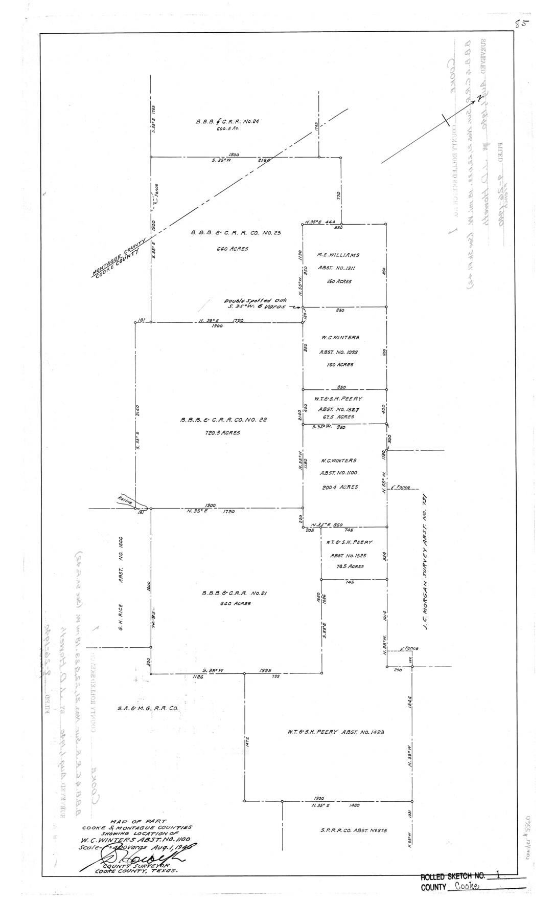
Cooke County Rolled Sketch 1
Map of part [of] Cooke & Montague Counties showing location of W.C. Winters abst. no. 1100
-
Map/Doc
5560
-
Collection
General Map Collection
-
Object Dates
1940/8/1 (Creation Date)
1940/9/26 (File Date)
-
People and Organizations
J.D. Howeth (Surveyor/Engineer)
-
Counties
Cooke Montague
-
Subjects
Surveying Rolled Sketch
-
Height x Width
26.2 x 15.8 inches
66.5 x 40.1 cm
-
Scale
1" = 400 varas
Part of: General Map Collection
Matagorda Bay Oil Area, Matagorda, Calhoun & Jackson Cos.

Print $40.00
- Digital $50.00
Matagorda Bay Oil Area, Matagorda, Calhoun & Jackson Cos.
1927
Size 34.9 x 66.8 inches
Map/Doc 2934
Morris County Rolled Sketch 2A

Print $20.00
- Digital $50.00
Morris County Rolled Sketch 2A
Size 24.0 x 18.7 inches
Map/Doc 10225
Jim Wells County Working Sketch 10

Print $20.00
- Digital $50.00
Jim Wells County Working Sketch 10
1952
Size 18.7 x 17.8 inches
Map/Doc 66608
Wichita County Rolled Sketch 19

Print $20.00
- Digital $50.00
Wichita County Rolled Sketch 19
1963
Size 28.5 x 30.9 inches
Map/Doc 8255
Hardeman County Sketch File A1

Print $14.00
- Digital $50.00
Hardeman County Sketch File A1
1891
Size 12.7 x 8.2 inches
Map/Doc 25045
Gaines County Sketch File 21

Print $6.00
- Digital $50.00
Gaines County Sketch File 21
1990
Size 11.2 x 8.8 inches
Map/Doc 23341
University Land Field Notes for Blocks 12, 13, and 14 in Andrews County, and Block 11 in Andrews and Winkler Counties

University Land Field Notes for Blocks 12, 13, and 14 in Andrews County, and Block 11 in Andrews and Winkler Counties
Map/Doc 81711
Webb County Working Sketch 98

Print $40.00
- Digital $50.00
Webb County Working Sketch 98
2012
Size 36.9 x 72.0 inches
Map/Doc 93276
New Map of San Antonio, Texas

Print $20.00
- Digital $50.00
New Map of San Antonio, Texas
1920
Size 17.2 x 14.2 inches
Map/Doc 97156

Map of Wilbarger County Young Land District formerly Fannin Land District

Print $20.00
- Digital $50.00
Map of Wilbarger County Young Land District formerly Fannin Land District
1859
Size 22.7 x 20.6 inches
Map/Doc 4146
Flight Mission No. DCL-7C, Frame 3, Kenedy County

Print $20.00
- Digital $50.00
Flight Mission No. DCL-7C, Frame 3, Kenedy County
1943
Size 18.5 x 22.3 inches
Map/Doc 85995
You may also like
Duval County Sketch File 80

Print $32.00
- Digital $50.00
Duval County Sketch File 80
Size 14.1 x 8.9 inches
Map/Doc 21492
Panola County Working Sketch 39

Print $20.00
- Digital $50.00
Panola County Working Sketch 39
1992
Map/Doc 71448
Tom Green County Sketch File 51

Print $20.00
- Digital $50.00
Tom Green County Sketch File 51
1884
Size 44.0 x 27.5 inches
Map/Doc 10403
[Surveys in the Bexar District along the Frio and Leona Rivers]
![136, [Surveys in the Bexar District along the Frio and Leona Rivers], General Map Collection](https://historictexasmaps.com/wmedia_w700/maps/136.tif.jpg)
Print $20.00
- Digital $50.00
[Surveys in the Bexar District along the Frio and Leona Rivers]
1842
Size 16.2 x 12.2 inches
Map/Doc 136
Rusk County Working Sketch 15

Print $20.00
- Digital $50.00
Rusk County Working Sketch 15
1972
Size 29.6 x 43.8 inches
Map/Doc 63650
Winkler County Working Sketch 17

Print $20.00
- Digital $50.00
Winkler County Working Sketch 17
1973
Size 36.5 x 36.7 inches
Map/Doc 72611
Duval County Rolled Sketch 30A

Print $40.00
- Digital $50.00
Duval County Rolled Sketch 30A
1896
Size 59.7 x 40.8 inches
Map/Doc 76145
Gaines County Working Sketch 8

Print $20.00
- Digital $50.00
Gaines County Working Sketch 8
1951
Size 21.8 x 24.8 inches
Map/Doc 69308
Bell County Working Sketch 16

Print $20.00
- Digital $50.00
Bell County Working Sketch 16
1983
Size 46.5 x 35.4 inches
Map/Doc 67356
Trinity River, South Extension Porters Bluff Sheet

Print $20.00
- Digital $50.00
Trinity River, South Extension Porters Bluff Sheet
1925
Size 16.3 x 24.4 inches
Map/Doc 69690
Galveston Island, showing division into lots

Print $40.00
- Digital $50.00
Galveston Island, showing division into lots
1839
Size 76.9 x 33.3 inches
Map/Doc 2036
Crockett County Rolled Sketch 70

Print $20.00
- Digital $50.00
Crockett County Rolled Sketch 70
1949
Size 15.1 x 17.0 inches
Map/Doc 5612