Hudspeth County Sketch File 13
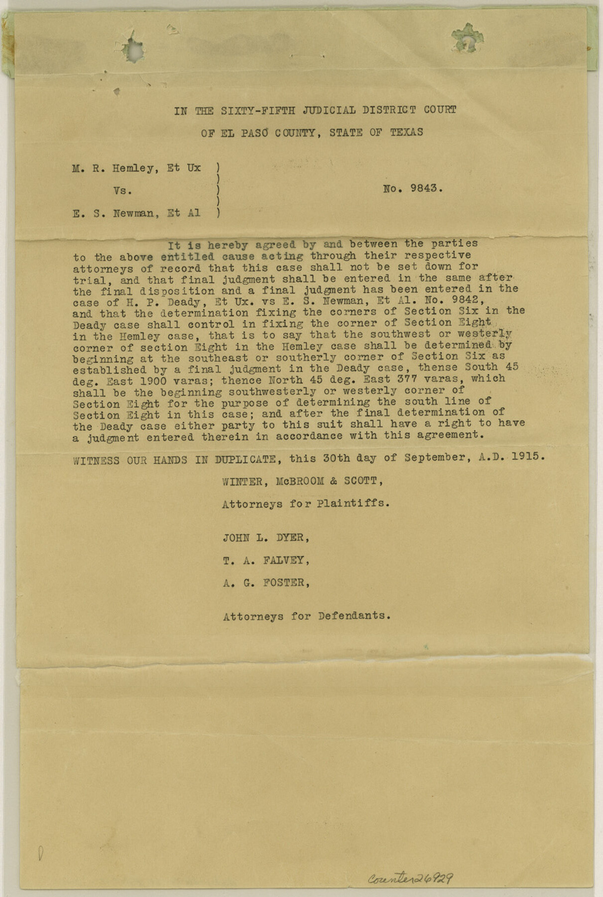
[Decree of Court - M. R. Hemley, et ux vs. E. S. Newman, et al]
-
Map/Doc
26929
-
Collection
General Map Collection
-
Object Dates
9/30/1915 (Creation Date)
5/15/1925 (File Date)
2/1914 (Survey Date)
5/1914 (Survey Date)
-
People and Organizations
J.A. Tivey (Surveyor/Engineer)
Murray Harris (Surveyor/Engineer)
R.E. Hardaway (Surveyor/Engineer)
Murray Harris (Draftsman)
R.E. Hardaway (Draftsman)
-
Counties
Hudspeth
-
Subjects
Surveying Sketch File
-
Height x Width
13.3 x 8.9 inches
33.8 x 22.6 cm
-
Medium
paper, print
Part of: General Map Collection
[Map of the Recognised Line M. EL. P. & P. R. R. from East Line of Bexar Land District to El Paso]
![85323, [Map of the Recognised Line M. EL. P. & P. R. R. from East Line of Bexar Land District to El Paso], General Map Collection](https://historictexasmaps.com/wmedia_w700/maps/85323.tif.jpg)
Print $40.00
- Digital $50.00
[Map of the Recognised Line M. EL. P. & P. R. R. from East Line of Bexar Land District to El Paso]
1857
Size 56.9 x 20.0 inches
Map/Doc 85323
Hopkins County Sketch File 26

Print $4.00
- Digital $50.00
Hopkins County Sketch File 26
Size 8.4 x 6.1 inches
Map/Doc 26736
Van Zandt County Rolled Sketch 8

Print $20.00
- Digital $50.00
Van Zandt County Rolled Sketch 8
1948
Size 38.4 x 23.9 inches
Map/Doc 8148
Bowie County Working Sketch 3

Print $20.00
- Digital $50.00
Bowie County Working Sketch 3
1913
Size 25.5 x 17.1 inches
Map/Doc 67407
Blanco County Sketch File 48

Print $6.00
- Digital $50.00
Blanco County Sketch File 48
1952
Size 11.7 x 9.0 inches
Map/Doc 14688
Mills County Working Sketch 17

Print $20.00
- Digital $50.00
Mills County Working Sketch 17
1963
Size 20.4 x 17.9 inches
Map/Doc 71047
Eastland County Sketch File 2b

Print $6.00
- Digital $50.00
Eastland County Sketch File 2b
1857
Size 11.1 x 8.8 inches
Map/Doc 21563
Hardin County Rolled Sketch 13

Print $20.00
- Digital $50.00
Hardin County Rolled Sketch 13
Size 36.0 x 42.3 inches
Map/Doc 9187
Starr County Rolled Sketch 24

Print $20.00
- Digital $50.00
Starr County Rolled Sketch 24
1938
Size 37.5 x 26.7 inches
Map/Doc 7808
Culberson County Rolled Sketch 20

Print $20.00
- Digital $50.00
Culberson County Rolled Sketch 20
1912
Size 30.0 x 18.2 inches
Map/Doc 5653
Copy of Surveyor's Field Book, Morris Browning - In Blocks 7, 5 & 4, I&GNRRCo., Hutchinson and Carson Counties, Texas

Print $2.00
- Digital $50.00
Copy of Surveyor's Field Book, Morris Browning - In Blocks 7, 5 & 4, I&GNRRCo., Hutchinson and Carson Counties, Texas
1888
Size 6.9 x 8.8 inches
Map/Doc 62275
Matagorda County NRC Article 33.136 Sketch 12

Print $32.00
- Digital $50.00
Matagorda County NRC Article 33.136 Sketch 12
2017
Size 22.0 x 34.0 inches
Map/Doc 94780
You may also like
Flight Mission No. DCL-7C, Frame 59, Kenedy County

Print $20.00
- Digital $50.00
Flight Mission No. DCL-7C, Frame 59, Kenedy County
1943
Size 15.4 x 15.2 inches
Map/Doc 86047
Burnet County Working Sketch 14

Print $20.00
- Digital $50.00
Burnet County Working Sketch 14
1978
Size 37.0 x 38.5 inches
Map/Doc 67857
Winkler County Sketch File 16

Print $30.00
- Digital $50.00
Winkler County Sketch File 16
1929
Size 14.2 x 8.7 inches
Map/Doc 40493
Kimble County Sketch File 34

Print $20.00
- Digital $50.00
Kimble County Sketch File 34
1963
Size 26.2 x 16.3 inches
Map/Doc 11931
Outer Continental Shelf Leasing Maps (Louisiana Offshore Operations)

Print $20.00
- Digital $50.00
Outer Continental Shelf Leasing Maps (Louisiana Offshore Operations)
1954
Size 25.5 x 15.3 inches
Map/Doc 76093
Preliminary Chart of the Northwestern Part of the Gulf of Mexico - Unfinished Proof

Print $40.00
Preliminary Chart of the Northwestern Part of the Gulf of Mexico - Unfinished Proof
1861
Size 31.5 x 68.9 inches
Map/Doc 95308
Interfaith's Official Map: The Woodlands, a real hometown for people and companies

Interfaith's Official Map: The Woodlands, a real hometown for people and companies
1997
Size 22.4 x 36.5 inches
Map/Doc 94286
Flight Mission No. DQO-8K, Frame 40, Galveston County

Print $20.00
- Digital $50.00
Flight Mission No. DQO-8K, Frame 40, Galveston County
1952
Size 18.5 x 22.3 inches
Map/Doc 85147
Val Verde County Working Sketch 1

Print $40.00
- Digital $50.00
Val Verde County Working Sketch 1
Size 34.8 x 58.2 inches
Map/Doc 72136
Montague County Sketch File 9

Print $18.00
- Digital $50.00
Montague County Sketch File 9
1872
Size 12.6 x 11.7 inches
Map/Doc 31724
Stonewall County Boundary File 2

Print $12.00
- Digital $50.00
Stonewall County Boundary File 2
Size 14.2 x 8.8 inches
Map/Doc 58955
Roberts County Working Sketch 15

Print $20.00
- Digital $50.00
Roberts County Working Sketch 15
1975
Size 40.5 x 38.7 inches
Map/Doc 63541