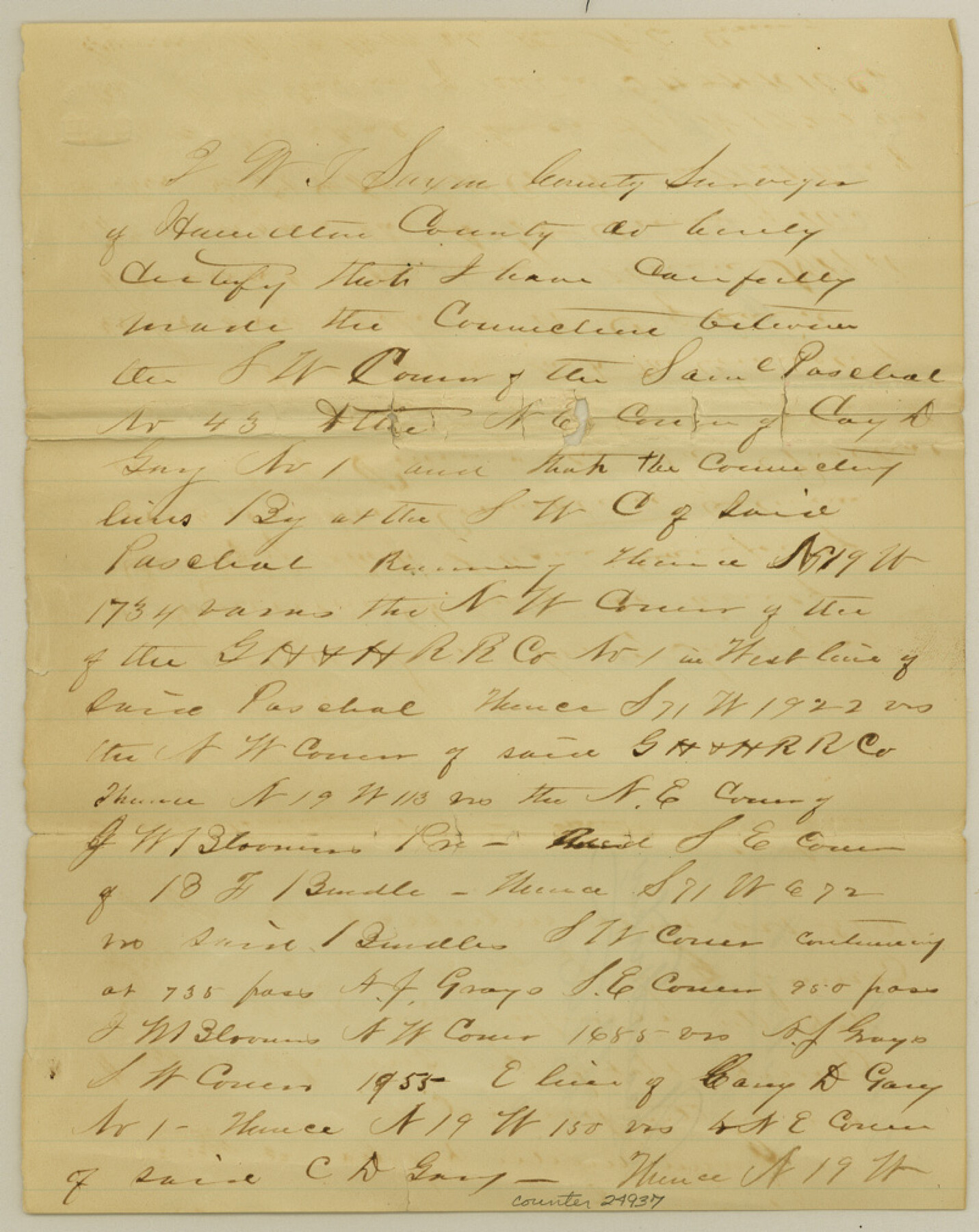
Hamilton County Sketch File 14
[Sketch and statement regarding Hamilton County School Land and surrounding surveys]
-
Map/Doc
24937
-
Collection
General Map Collection
-
Object Dates
1879/5/10 (File Date)
-
People and Organizations
W.T. Saxon (Surveyor/Engineer)
-
Counties
Hamilton
-
Subjects
Surveying Sketch File
-
Height x Width
10.1 x 8.0 inches
25.7 x 20.3 cm
-
Medium
paper, manuscript
-
Features
Cowhouse Creek
Part of: General Map Collection
Map of Webb County

Print $20.00
- Digital $50.00
Map of Webb County
1895
Size 34.8 x 27.0 inches
Map/Doc 4132
Ochiltree County

Print $20.00
- Digital $50.00
Ochiltree County
1908
Size 42.6 x 37.5 inches
Map/Doc 66958
[Plat and field notes of 3.107 acre tract for Clement Cove Harbor Company]
![60397, [Plat and field notes of 3.107 acre tract for Clement Cove Harbor Company], General Map Collection](https://historictexasmaps.com/wmedia_w700/maps/60397-1.tif.jpg)
Print $20.00
- Digital $50.00
[Plat and field notes of 3.107 acre tract for Clement Cove Harbor Company]
1987
Size 24.2 x 36.5 inches
Map/Doc 60397
Presidio County Sketch File 65

Print $6.00
- Digital $50.00
Presidio County Sketch File 65
1940
Size 11.0 x 15.3 inches
Map/Doc 34654

Index for Texas Railroad ROW & track maps available on microfilm at THD & Archives and Records

Print $2.00
- Digital $50.00
Index for Texas Railroad ROW & track maps available on microfilm at THD & Archives and Records
1977
Size 11.2 x 8.8 inches
Map/Doc 60756
Grayson County Sketch File 1

Print $2.00
- Digital $50.00
Grayson County Sketch File 1
1854
Size 8.4 x 3.3 inches
Map/Doc 24459
Terrell County Rolled Sketch 54

Print $20.00
- Digital $50.00
Terrell County Rolled Sketch 54
Size 18.8 x 22.6 inches
Map/Doc 7973
Map of Main Line Houston & Tex. Centr. Railway from Dallas to Red River City

Print $40.00
- Digital $50.00
Map of Main Line Houston & Tex. Centr. Railway from Dallas to Red River City
Size 37.1 x 84.9 inches
Map/Doc 64089
Palo Pinto County

Print $20.00
- Digital $50.00
Palo Pinto County
1856
Size 29.9 x 20.9 inches
Map/Doc 1394

Flight Mission No. CGI-2N, Frame 182, Cameron County

Print $20.00
- Digital $50.00
Flight Mission No. CGI-2N, Frame 182, Cameron County
1954
Size 18.5 x 22.2 inches
Map/Doc 84542
You may also like
Brewster County Rolled Sketch 111

Print $20.00
- Digital $50.00
Brewster County Rolled Sketch 111
1962
Size 32.2 x 44.7 inches
Map/Doc 8512
Wheeler County

Print $20.00
- Digital $50.00
Wheeler County
1899
Size 42.2 x 37.9 inches
Map/Doc 95672
Foard County Working Sketch 8

Print $40.00
- Digital $50.00
Foard County Working Sketch 8
1975
Size 57.0 x 40.0 inches
Map/Doc 69199
Potter County

Print $20.00
- Digital $50.00
Potter County
1909
Size 47.5 x 40.8 inches
Map/Doc 66984
[A. Dubois Survey and vicinity]
![91524, [A. Dubois Survey and vicinity], Twichell Survey Records](https://historictexasmaps.com/wmedia_w700/maps/91524-1.tif.jpg)
Print $3.00
- Digital $50.00
[A. Dubois Survey and vicinity]
Size 11.4 x 14.6 inches
Map/Doc 91524
Section B Tech Memorial Park, Inc.

Print $3.00
- Digital $50.00
Section B Tech Memorial Park, Inc.
Size 14.1 x 10.0 inches
Map/Doc 92268
Bastrop County Working Sketch 7

Print $20.00
- Digital $50.00
Bastrop County Working Sketch 7
1930
Size 32.7 x 29.7 inches
Map/Doc 67307
Leon County Working Sketch 33

Print $20.00
- Digital $50.00
Leon County Working Sketch 33
1978
Size 43.4 x 41.6 inches
Map/Doc 70432
Webb County Boundary File 6

Print $123.00
- Digital $50.00
Webb County Boundary File 6
Size 14.4 x 8.8 inches
Map/Doc 59786
Kendall County Working Sketch 5

Print $20.00
- Digital $50.00
Kendall County Working Sketch 5
1946
Size 30.4 x 28.6 inches
Map/Doc 66677
Upton County Rolled Sketch 57

Print $20.00
- Digital $50.00
Upton County Rolled Sketch 57
Size 30.1 x 41.8 inches
Map/Doc 8090
El Paso County Rolled Sketch 52

Print $20.00
- Digital $50.00
El Paso County Rolled Sketch 52
1929
Size 19.1 x 24.3 inches
Map/Doc 5850