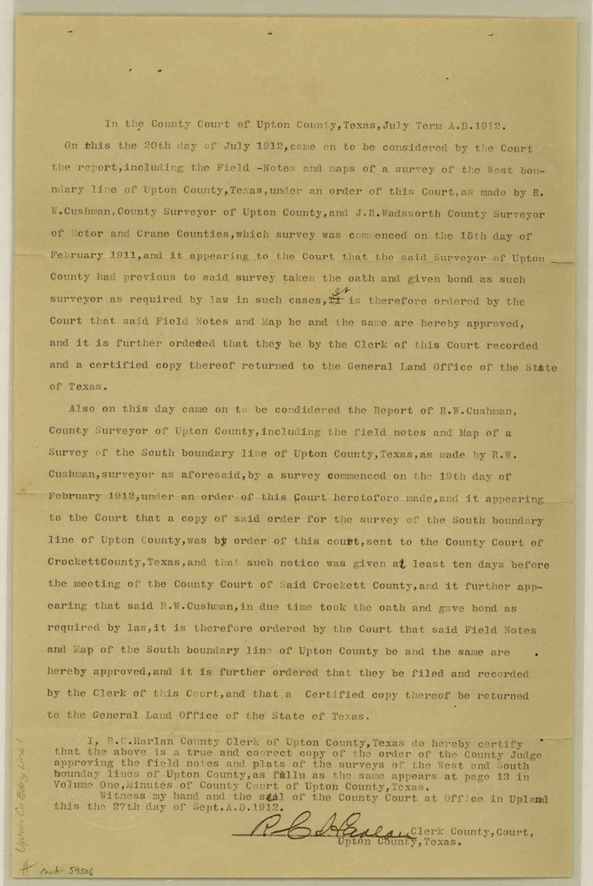
Upton County Boundary File 1
Certified Copy of Orders By Co. Judge Re Establishment Co lines Upton County
-
Map/Doc
59506
-
Collection
General Map Collection
-
Counties
Upton
-
Subjects
County Boundaries
-
Height x Width
13.4 x 9.0 inches
34.0 x 22.9 cm
Part of: General Map Collection
Blanco County Sketch File 18

Print $4.00
- Digital $50.00
Blanco County Sketch File 18
1877
Size 12.6 x 8.5 inches
Map/Doc 14594
Bastrop County Sketch File 13

Print $6.00
- Digital $50.00
Bastrop County Sketch File 13
1845
Size 10.1 x 15.8 inches
Map/Doc 14070
Fort Bend County Sketch File 6

Print $2.00
- Digital $50.00
Fort Bend County Sketch File 6
Size 4.7 x 8.4 inches
Map/Doc 22891

San Augustine County Working Sketch 19

Print $20.00
- Digital $50.00
San Augustine County Working Sketch 19
1967
Size 22.9 x 30.6 inches
Map/Doc 63707
Pecos County Working Sketch 92

Print $40.00
- Digital $50.00
Pecos County Working Sketch 92
1966
Size 31.4 x 62.2 inches
Map/Doc 71565
Kleberg County Rolled Sketch 10-14

Print $20.00
- Digital $50.00
Kleberg County Rolled Sketch 10-14
1951
Size 38.0 x 33.2 inches
Map/Doc 9404
Terry County Sketch File 2

Print $8.00
- Digital $50.00
Terry County Sketch File 2
Size 8.9 x 11.4 inches
Map/Doc 38012
Map of Jefferson County

Print $20.00
- Digital $50.00
Map of Jefferson County
1840
Size 32.7 x 23.4 inches
Map/Doc 3725
Flight Mission No. BQY-4M, Frame 70, Harris County

Print $20.00
- Digital $50.00
Flight Mission No. BQY-4M, Frame 70, Harris County
1953
Size 18.7 x 22.4 inches
Map/Doc 85279
Tom Green County Working Sketch 2

Print $20.00
- Digital $50.00
Tom Green County Working Sketch 2
1917
Size 21.1 x 32.9 inches
Map/Doc 69371
Galveston County Working Sketch 23

Print $20.00
- Digital $50.00
Galveston County Working Sketch 23
1988
Size 35.8 x 30.6 inches
Map/Doc 69360
You may also like
McCulloch County

Print $20.00
- Digital $50.00
McCulloch County
1949
Size 47.0 x 35.8 inches
Map/Doc 73234
Chambers County Rolled Sketch 24

Print $40.00
- Digital $50.00
Chambers County Rolled Sketch 24
1940
Size 38.2 x 49.9 inches
Map/Doc 8594
[H. & T. C. Block 47 and vicinity]
![91171, [H. & T. C. Block 47 and vicinity], Twichell Survey Records](https://historictexasmaps.com/wmedia_w700/maps/91171-1.tif.jpg)
Print $20.00
- Digital $50.00
[H. & T. C. Block 47 and vicinity]
1891
Size 19.4 x 15.3 inches
Map/Doc 91171
Uvalde County Boundary File 2

Print $5.00
- Digital $50.00
Uvalde County Boundary File 2
Size 13.1 x 9.5 inches
Map/Doc 59556
Hudspeth County Sketch File 11b

Print $16.00
- Digital $50.00
Hudspeth County Sketch File 11b
Size 14.2 x 8.9 inches
Map/Doc 26914
Wise County Working Sketch 4

Print $20.00
- Digital $50.00
Wise County Working Sketch 4
1948
Size 33.2 x 31.5 inches
Map/Doc 72618
Flight Mission No. BRA-7M, Frame 85, Jefferson County

Print $20.00
- Digital $50.00
Flight Mission No. BRA-7M, Frame 85, Jefferson County
1953
Size 18.7 x 22.4 inches
Map/Doc 85507
First Addition to Amherst Suburban Farms

Print $20.00
- Digital $50.00
First Addition to Amherst Suburban Farms
Size 26.5 x 20.6 inches
Map/Doc 92430
Zavala County Sketch File 16

Print $20.00
- Digital $50.00
Zavala County Sketch File 16
1900
Size 22.9 x 16.9 inches
Map/Doc 12730
Briscoe County Sketch File 2a

Print $4.00
- Digital $50.00
Briscoe County Sketch File 2a
Size 6.2 x 7.1 inches
Map/Doc 16415
Dallam County Working Sketch 2a

Print $20.00
- Digital $50.00
Dallam County Working Sketch 2a
1886
Size 17.9 x 15.9 inches
Map/Doc 78213
Baylor County Rolled Sketch 11

Print $20.00
- Digital $50.00
Baylor County Rolled Sketch 11
Size 19.4 x 19.9 inches
Map/Doc 5128