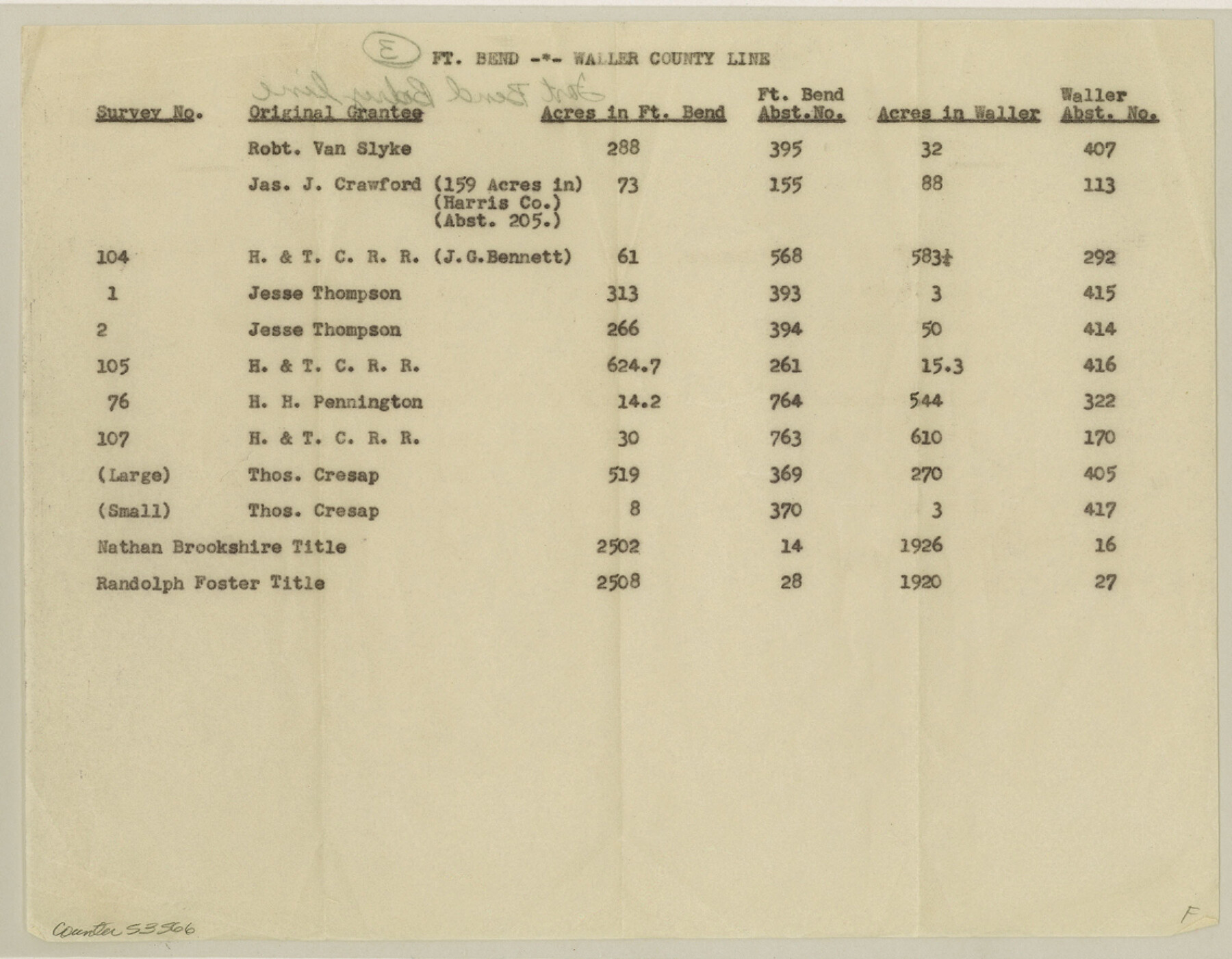
Fort Bend County Boundary File 3
Ft. Bend-Waller County Line
-
Map/Doc
53566
-
Collection
General Map Collection
-
Counties
Fort Bend
-
Subjects
County Boundaries
-
Height x Width
8.8 x 11.3 inches
22.4 x 28.7 cm
Part of: General Map Collection
Right of Way and Track Map, The Missouri, Kansas and Texas Ry. of Texas operated by the Missouri, Kansas and Texas Ry. of Texas, Henrietta Division

Print $40.00
- Digital $50.00
Right of Way and Track Map, The Missouri, Kansas and Texas Ry. of Texas operated by the Missouri, Kansas and Texas Ry. of Texas, Henrietta Division
1918
Size 25.4 x 57.2 inches
Map/Doc 64073
Travis County Sketch File 65

Print $4.00
- Digital $50.00
Travis County Sketch File 65
1948
Size 9.1 x 9.1 inches
Map/Doc 38438
Tarrant County Sketch File 33

Print $48.00
- Digital $50.00
Tarrant County Sketch File 33
1954
Size 11.6 x 8.8 inches
Map/Doc 37759
Flight Mission No. DQO-2K, Frame 149, Galveston County

Print $20.00
- Digital $50.00
Flight Mission No. DQO-2K, Frame 149, Galveston County
1952
Size 18.8 x 22.4 inches
Map/Doc 85046
[Map of Lt. Brulls scout in Haskell, Throckmorton, Jones and Shackelford Counties]
![65399, [Map of Lt. Brulls scout in Haskell, Throckmorton, Jones and Shackelford Counties], General Map Collection](https://historictexasmaps.com/wmedia_w700/maps/65399-1.tif.jpg)
Print $3.00
- Digital $50.00
[Map of Lt. Brulls scout in Haskell, Throckmorton, Jones and Shackelford Counties]
1873
Size 10.1 x 11.9 inches
Map/Doc 65399
San Luis Pass to East Matagorda Bay

Print $20.00
- Digital $50.00
San Luis Pass to East Matagorda Bay
1960
Size 34.6 x 46.5 inches
Map/Doc 69963
Scurry County

Print $20.00
- Digital $50.00
Scurry County
1921
Size 42.4 x 39.1 inches
Map/Doc 95637
Packery Channel

Print $20.00
- Digital $50.00
Packery Channel
1975
Size 26.2 x 21.5 inches
Map/Doc 2991
Galveston County NRC Article 33.136 Sketch 15

Print $24.00
- Digital $50.00
Galveston County NRC Article 33.136 Sketch 15
2002
Size 23.0 x 35.0 inches
Map/Doc 77046
Kenedy County Rolled Sketch 4A

Print $40.00
- Digital $50.00
Kenedy County Rolled Sketch 4A
1904
Size 40.0 x 56.5 inches
Map/Doc 9332
Fort Bend County Working Sketch 18

Print $20.00
- Digital $50.00
Fort Bend County Working Sketch 18
1957
Size 34.7 x 38.2 inches
Map/Doc 69224
Flight Mission No. BRE-5P, Frame 191, Nueces County

Print $20.00
- Digital $50.00
Flight Mission No. BRE-5P, Frame 191, Nueces County
1956
Size 18.7 x 22.5 inches
Map/Doc 86837
You may also like
Reagan County Sketch File 1

Print $20.00
- Digital $50.00
Reagan County Sketch File 1
1914
Size 24.3 x 30.3 inches
Map/Doc 12210
[Part of Block GG and river sections 68 1/2 -73]
![90471, [Part of Block GG and river sections 68 1/2 -73], Twichell Survey Records](https://historictexasmaps.com/wmedia_w700/maps/90471-1.tif.jpg)
Print $20.00
- Digital $50.00
[Part of Block GG and river sections 68 1/2 -73]
Size 28.0 x 19.2 inches
Map/Doc 90471

Sabine Pass, Texas

Print $40.00
- Digital $50.00
Sabine Pass, Texas
1874
Size 32.2 x 53.2 inches
Map/Doc 69837
Chambers County Sketch File 14

Print $8.00
- Digital $50.00
Chambers County Sketch File 14
1862
Size 4.3 x 5.1 inches
Map/Doc 17560
Crane County Working Sketch 6

Print $40.00
- Digital $50.00
Crane County Working Sketch 6
1928
Size 92.2 x 25.3 inches
Map/Doc 68283
Galveston Harbor, Texas - U.S. Harbor Lines - Galveston Harbor, Galveston Channel, Channel from Galveston Harbor to Texas City and Channel to Port Bolivar

Print $20.00
- Digital $50.00
Galveston Harbor, Texas - U.S. Harbor Lines - Galveston Harbor, Galveston Channel, Channel from Galveston Harbor to Texas City and Channel to Port Bolivar
1939
Size 39.4 x 26.7 inches
Map/Doc 73631
Kaufman County Working Sketch Graphic Index

Print $20.00
- Digital $50.00
Kaufman County Working Sketch Graphic Index
1942
Size 46.1 x 38.3 inches
Map/Doc 76601
Travis County Sketch File 57

Print $8.00
- Digital $50.00
Travis County Sketch File 57
1947
Size 11.4 x 8.8 inches
Map/Doc 38402
Reeves County Working Sketch 10

Print $20.00
- Digital $50.00
Reeves County Working Sketch 10
1956
Size 26.0 x 37.2 inches
Map/Doc 63453
Wharton County Rolled Sketch 13

Print $20.00
- Digital $50.00
Wharton County Rolled Sketch 13
1990
Size 22.4 x 28.1 inches
Map/Doc 8238
Briscoe County

Print $20.00
- Digital $50.00
Briscoe County
1879
Size 21.7 x 19.3 inches
Map/Doc 3332