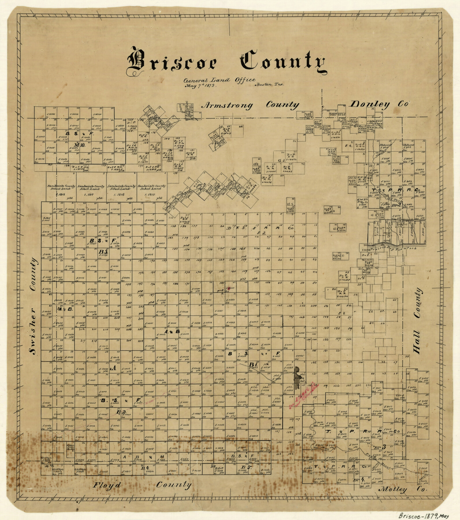
Briscoe County
-
Map/Doc
3332
-
Collection
General Map Collection
-
Object Dates
5/7/1879 (Creation Date)
-
Counties
Briscoe
-
Subjects
County
-
Height x Width
21.7 x 19.3 inches
55.1 x 49.0 cm
-
Features
Turkey Creek
West Fork of Gypsum Creek
Gypsum Creek
Charlie's Creek
Byrne's Fork of Prairie Dog Town Fork of Red River
Prairie Dog Town Fork of Red River
Pease River
Warren Creek
Robert's Creek
Part of: General Map Collection
Flight Mission No. DQO-8K, Frame 140, Galveston County

Print $20.00
- Digital $50.00
Flight Mission No. DQO-8K, Frame 140, Galveston County
1952
Size 18.7 x 22.4 inches
Map/Doc 85202
Armstrong County Working Sketch 11

Print $20.00
- Digital $50.00
Armstrong County Working Sketch 11
2025
Map/Doc 97507
Terrell County Working Sketch 84d

Print $20.00
- Digital $50.00
Terrell County Working Sketch 84d
1992
Size 18.4 x 31.5 inches
Map/Doc 69608
Hansford County Working Sketch 7

Print $20.00
- Digital $50.00
Hansford County Working Sketch 7
1969
Size 27.7 x 23.9 inches
Map/Doc 63379
Val Verde County

Print $20.00
- Digital $50.00
Val Verde County
1944
Size 42.3 x 37.8 inches
Map/Doc 73311
Live Oak County Working Sketch 1

Print $20.00
- Digital $50.00
Live Oak County Working Sketch 1
Size 20.4 x 29.1 inches
Map/Doc 70586
Van Zandt County Working Sketch 11

Print $20.00
- Digital $50.00
Van Zandt County Working Sketch 11
1982
Size 15.2 x 9.3 inches
Map/Doc 72261
Live Oak County Working Sketch 2

Print $20.00
- Digital $50.00
Live Oak County Working Sketch 2
1891
Size 17.9 x 18.2 inches
Map/Doc 70587
San Patricio County Rolled Sketch 27

Print $40.00
- Digital $50.00
San Patricio County Rolled Sketch 27
Size 49.5 x 37.8 inches
Map/Doc 9890
Taylor County Sketch File 19

Print $10.00
- Digital $50.00
Taylor County Sketch File 19
1945
Size 14.2 x 8.8 inches
Map/Doc 37816
Perspective Map of the City of Laredo

Print $20.00
- Digital $50.00
Perspective Map of the City of Laredo
1892
Size 24.2 x 36.3 inches
Map/Doc 97096
Crane County Working Sketch 26

Print $20.00
- Digital $50.00
Crane County Working Sketch 26
1971
Size 32.4 x 33.0 inches
Map/Doc 68303
You may also like
Comanche County Working Sketch 19

Print $20.00
- Digital $50.00
Comanche County Working Sketch 19
1973
Size 28.9 x 40.3 inches
Map/Doc 68153
Map of Lee County

Print $20.00
- Digital $50.00
Map of Lee County
1888
Size 41.6 x 40.1 inches
Map/Doc 5013
Burleson County Working Sketch 26

Print $20.00
- Digital $50.00
Burleson County Working Sketch 26
1981
Size 10.1 x 30.5 inches
Map/Doc 67745
Brooks County Working Sketch 13

Print $20.00
- Digital $50.00
Brooks County Working Sketch 13
1943
Size 22.4 x 31.9 inches
Map/Doc 67797
Shackelford County Sketch File 5

Print $4.00
- Digital $50.00
Shackelford County Sketch File 5
1885
Size 12.3 x 7.6 inches
Map/Doc 36578
Flight Mission No. DQO-11K, Frame 24, Galveston County

Print $20.00
- Digital $50.00
Flight Mission No. DQO-11K, Frame 24, Galveston County
1952
Size 18.6 x 22.4 inches
Map/Doc 85221
[Northwest part of County]
![90865, [Northwest part of County], Twichell Survey Records](https://historictexasmaps.com/wmedia_w700/maps/90865-2.tif.jpg)
Print $20.00
- Digital $50.00
[Northwest part of County]
Size 32.3 x 22.3 inches
Map/Doc 90865
Goliad County Working Sketch 3

Print $40.00
- Digital $50.00
Goliad County Working Sketch 3
1916
Size 42.8 x 76.4 inches
Map/Doc 63193
Houston County Working Sketch 19

Print $20.00
- Digital $50.00
Houston County Working Sketch 19
1976
Size 33.6 x 24.2 inches
Map/Doc 66249
Flight Mission No. DQN-2K, Frame 97, Calhoun County

Print $20.00
- Digital $50.00
Flight Mission No. DQN-2K, Frame 97, Calhoun County
1953
Size 18.7 x 22.4 inches
Map/Doc 84287
Kimble County Sketch File 9a

Print $4.00
- Digital $50.00
Kimble County Sketch File 9a
Size 12.4 x 9.2 inches
Map/Doc 28929
Flight Mission No. DQN-5K, Frame 47, Calhoun County

Print $20.00
- Digital $50.00
Flight Mission No. DQN-5K, Frame 47, Calhoun County
1953
Size 18.5 x 22.2 inches
Map/Doc 84392