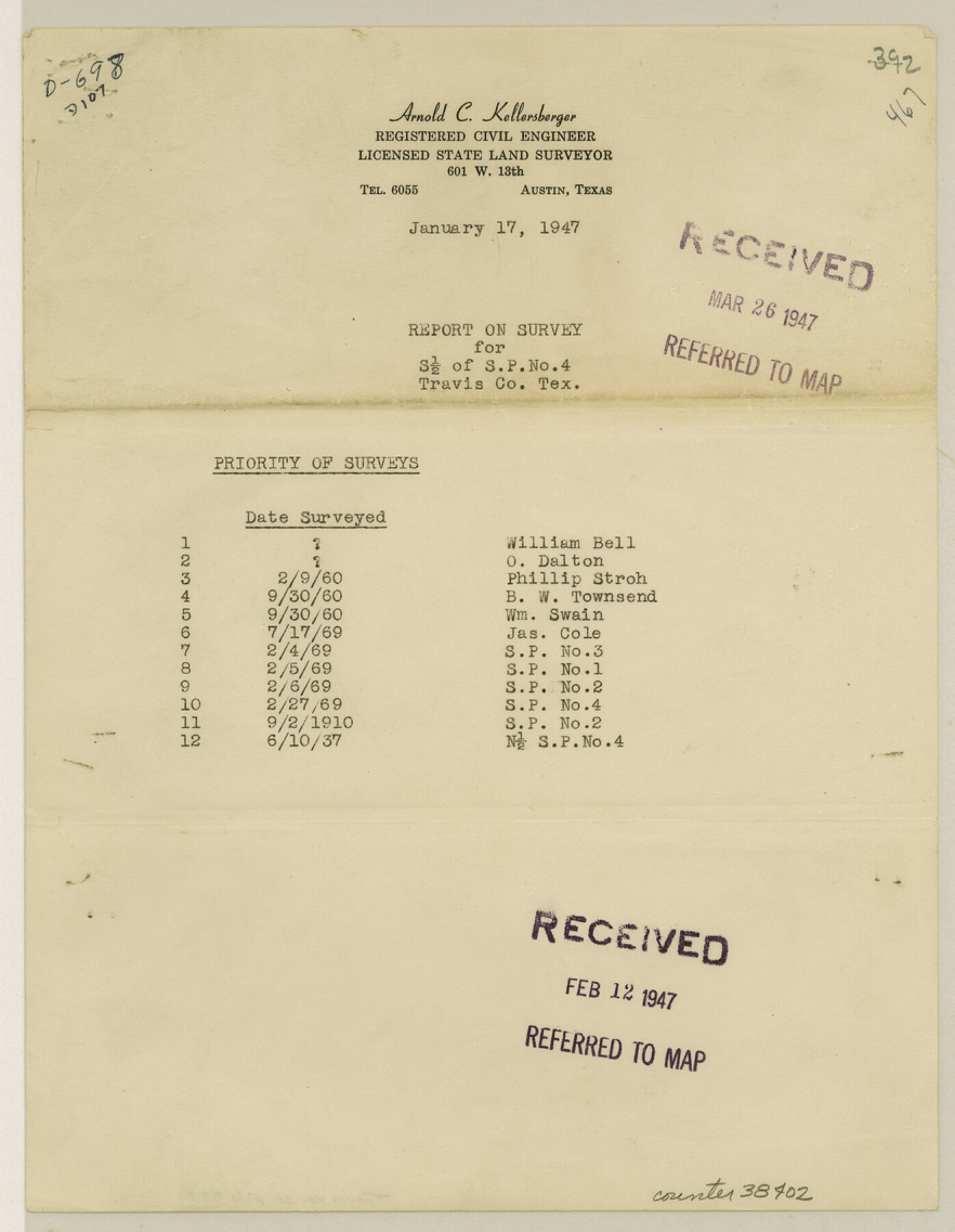
Travis County Sketch File 57
[Report on survey for south 1/2 of S. P. R.R. No. 4 northwest from Austin]
-
Map/Doc
38402
-
Collection
General Map Collection
-
Object Dates
1/17/1947 (Creation Date)
12/27/1947 (File Date)
-
People and Organizations
Arnold C. Kellersberger (Surveyor/Engineer)
-
Counties
Travis
-
Subjects
Surveying Sketch File
-
Height x Width
11.4 x 8.8 inches
29.0 x 22.4 cm
-
Medium
paper, print
Part of: General Map Collection
Robertson County Working Sketch 6

Print $20.00
- Digital $50.00
Robertson County Working Sketch 6
1981
Size 14.1 x 15.9 inches
Map/Doc 63579
Hardin County Sketch File 64

Print $24.00
- Digital $50.00
Hardin County Sketch File 64
1936
Size 24.5 x 25.6 inches
Map/Doc 11638
Flight Mission No. BQR-22K, Frame 38, Brazoria County

Print $20.00
- Digital $50.00
Flight Mission No. BQR-22K, Frame 38, Brazoria County
1953
Size 18.5 x 22.3 inches
Map/Doc 84122
Bee County Boundary File 2

Print $10.00
- Digital $50.00
Bee County Boundary File 2
Size 8.8 x 6.8 inches
Map/Doc 50435
Brewster County Rolled Sketch 17

Print $40.00
- Digital $50.00
Brewster County Rolled Sketch 17
Size 25.1 x 63.4 inches
Map/Doc 5195
Flight Mission No. DQN-1K, Frame 77, Calhoun County

Print $20.00
- Digital $50.00
Flight Mission No. DQN-1K, Frame 77, Calhoun County
1953
Size 18.5 x 22.2 inches
Map/Doc 84162
Brewster County Working Sketch 103

Print $40.00
- Digital $50.00
Brewster County Working Sketch 103
1980
Size 48.4 x 31.1 inches
Map/Doc 67703
Uvalde County Working Sketch 35

Print $20.00
- Digital $50.00
Uvalde County Working Sketch 35
1964
Size 30.3 x 30.2 inches
Map/Doc 72105
Nacogdoches County Sketch File 17

Print $2.00
- Digital $50.00
Nacogdoches County Sketch File 17
1867
Size 15.4 x 8.7 inches
Map/Doc 32267
Duval County Sketch File 38

Print $64.00
- Digital $50.00
Duval County Sketch File 38
Size 38.2 x 19.5 inches
Map/Doc 10372
Flight Mission No. DQN-5K, Frame 24, Calhoun County

Print $20.00
- Digital $50.00
Flight Mission No. DQN-5K, Frame 24, Calhoun County
1953
Size 18.5 x 22.1 inches
Map/Doc 84375
Panola County Sketch File 20

Print $22.00
- Digital $50.00
Panola County Sketch File 20
Size 8.3 x 14.6 inches
Map/Doc 33485
You may also like
Gregg County Working Sketch 12

Print $20.00
- Digital $50.00
Gregg County Working Sketch 12
1940
Size 11.0 x 18.9 inches
Map/Doc 63279
Sterling County Boundary File 1

Print $56.00
- Digital $50.00
Sterling County Boundary File 1
Size 9.0 x 8.7 inches
Map/Doc 58919
Nueces County Rolled Sketch 79

Print $20.00
- Digital $50.00
Nueces County Rolled Sketch 79
1894
Size 38.1 x 31.3 inches
Map/Doc 9627
Jeff Davis County Rolled Sketch 37

Print $20.00
- Digital $50.00
Jeff Davis County Rolled Sketch 37
1992
Size 29.3 x 35.5 inches
Map/Doc 6380
Orange County Rolled Sketch 20

Print $40.00
- Digital $50.00
Orange County Rolled Sketch 20
1947
Size 35.2 x 64.3 inches
Map/Doc 9645
Webb County Rolled Sketch 44

Print $20.00
- Digital $50.00
Webb County Rolled Sketch 44
1941
Size 23.9 x 20.1 inches
Map/Doc 8199
Schleicher County Working Sketch 6

Print $20.00
- Digital $50.00
Schleicher County Working Sketch 6
1917
Size 24.6 x 19.3 inches
Map/Doc 63808
The Judicial District/County of Lavaca. Created, January 29, 1842

Print $20.00
The Judicial District/County of Lavaca. Created, January 29, 1842
2020
Size 14.6 x 21.7 inches
Map/Doc 96331
Henderson County Sketch File 3

Print $4.00
- Digital $50.00
Henderson County Sketch File 3
1852
Size 10.3 x 8.4 inches
Map/Doc 26321

Mills County Boundary File 5b

Print $8.00
- Digital $50.00
Mills County Boundary File 5b
Size 14.2 x 8.7 inches
Map/Doc 57307
Parker County Sketch File 39

Print $4.00
- Digital $50.00
Parker County Sketch File 39
Size 8.0 x 12.7 inches
Map/Doc 33583