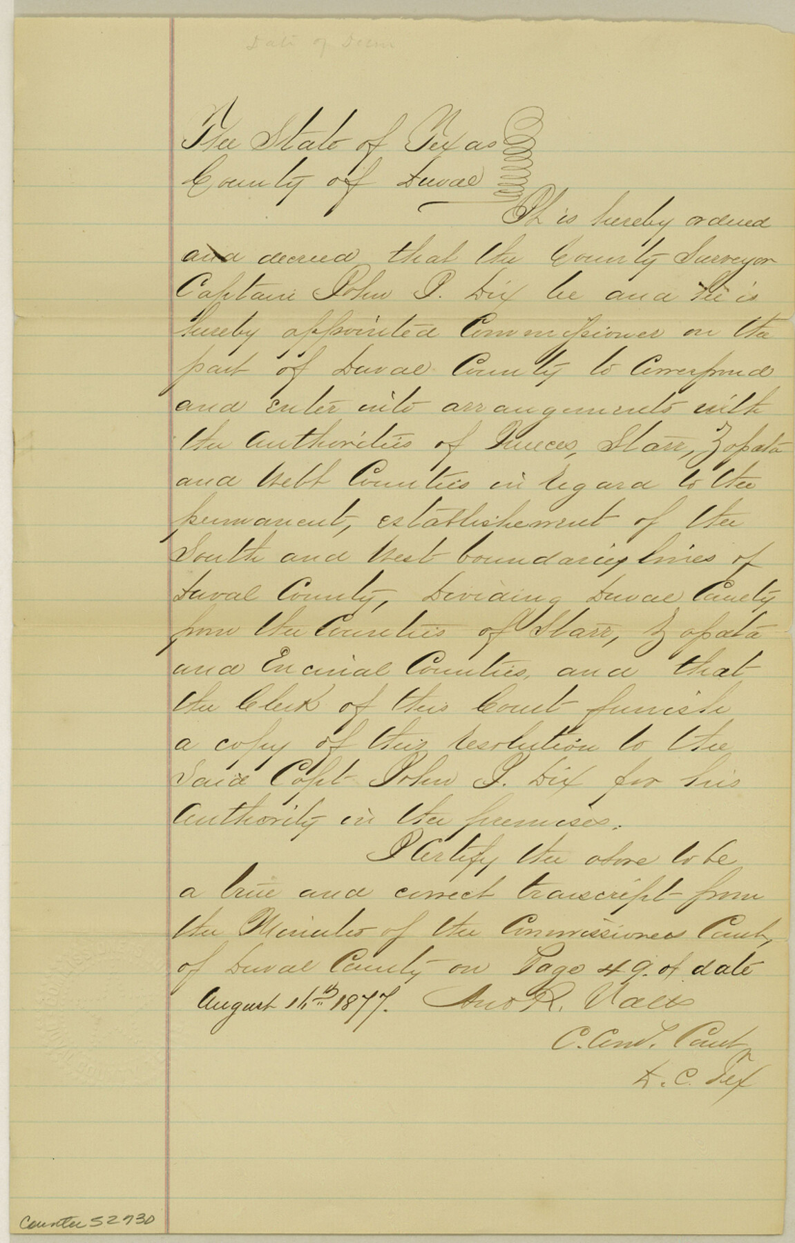
Duval County Boundary File 3b
Duval County Authority to run Boundary lines
-
Map/Doc
52730
-
Collection
General Map Collection
-
Counties
Duval
-
Subjects
County Boundaries
-
Height x Width
12.9 x 8.2 inches
32.8 x 20.8 cm
Part of: General Map Collection

Leon County Working Sketch 48

Print $20.00
- Digital $50.00
Leon County Working Sketch 48
1980
Size 29.2 x 33.7 inches
Map/Doc 70447
Kent County Sketch File 5

Print $26.00
- Digital $50.00
Kent County Sketch File 5
1888
Size 14.2 x 8.7 inches
Map/Doc 28827
South Part Crockett County

Print $40.00
- Digital $50.00
South Part Crockett County
1977
Size 39.7 x 51.4 inches
Map/Doc 73122
Matagorda County Sketch File 5

Print $4.00
- Digital $50.00
Matagorda County Sketch File 5
Size 10.0 x 8.0 inches
Map/Doc 30736
Trinity County Sketch File 26

Print $8.00
- Digital $50.00
Trinity County Sketch File 26
1885
Size 13.1 x 8.4 inches
Map/Doc 38558
Harris County Rolled Sketch 60

Print $20.00
- Digital $50.00
Harris County Rolled Sketch 60
1927
Size 27.4 x 21.3 inches
Map/Doc 6106
Presidio County Working Sketch 33

Print $40.00
- Digital $50.00
Presidio County Working Sketch 33
1947
Size 41.6 x 50.6 inches
Map/Doc 71710
Right of Way and Track Map International & Gt Northern Ry. operated by the International & Gt. Northern Ry. Co., San Antonio Division

Print $40.00
- Digital $50.00
Right of Way and Track Map International & Gt Northern Ry. operated by the International & Gt. Northern Ry. Co., San Antonio Division
1917
Size 25.7 x 63.1 inches
Map/Doc 64586
Threading the Islands: Which track fits?

Threading the Islands: Which track fits?
1986
Size 20.5 x 14.7 inches
Map/Doc 96838
Martin County Working Sketch 8

Print $40.00
- Digital $50.00
Martin County Working Sketch 8
1971
Size 53.1 x 36.8 inches
Map/Doc 70826
Garza County Rolled Sketch 17

Print $20.00
- Digital $50.00
Garza County Rolled Sketch 17
1959
Size 32.3 x 37.6 inches
Map/Doc 6003
You may also like
The Judicial District/Counties, Late Spring 1842

Print $20.00
The Judicial District/Counties, Late Spring 1842
2020
Size 24.5 x 21.7 inches
Map/Doc 96356

Schönberg's map of Texas.

Print $20.00
Schönberg's map of Texas.
1866
Size 11.0 x 13.0 inches
Map/Doc 93575
Zapata County Boundary File 1

Print $2.00
- Digital $50.00
Zapata County Boundary File 1
Size 11.4 x 9.0 inches
Map/Doc 60227
DeWitt County Sketch File 8

Print $4.00
- Digital $50.00
DeWitt County Sketch File 8
1876
Size 8.5 x 5.2 inches
Map/Doc 20818
Dallas County Sketch File 17

Print $20.00
- Digital $50.00
Dallas County Sketch File 17
Size 17.1 x 18.0 inches
Map/Doc 11285
Map of the State of Texas

Print $40.00
- Digital $50.00
Map of the State of Texas
1879
Size 102.3 x 56.2 inches
Map/Doc 93384
Map of the Houston Ship Channel showing all industries, railways, public and private docks, and approximate all original surveys in the vicinity of the channel

Print $20.00
- Digital $50.00
Map of the Houston Ship Channel showing all industries, railways, public and private docks, and approximate all original surveys in the vicinity of the channel
1925
Size 14.5 x 30.2 inches
Map/Doc 4666
Map of Texas Compiled from surveys recorded in the General Land Office

Print $20.00
Map of Texas Compiled from surveys recorded in the General Land Office
1851
Size 31.4 x 25.3 inches
Map/Doc 76209
Trinity River, Red Bank Sheet

Print $20.00
- Digital $50.00
Trinity River, Red Bank Sheet
1925
Size 16.4 x 24.4 inches
Map/Doc 69687
Brewster County Working Sketch 2

Print $20.00
- Digital $50.00
Brewster County Working Sketch 2
1907
Size 29.0 x 26.4 inches
Map/Doc 67535
Presidio County Sketch File 39

Print $6.00
- Digital $50.00
Presidio County Sketch File 39
1912
Size 13.3 x 8.9 inches
Map/Doc 34512