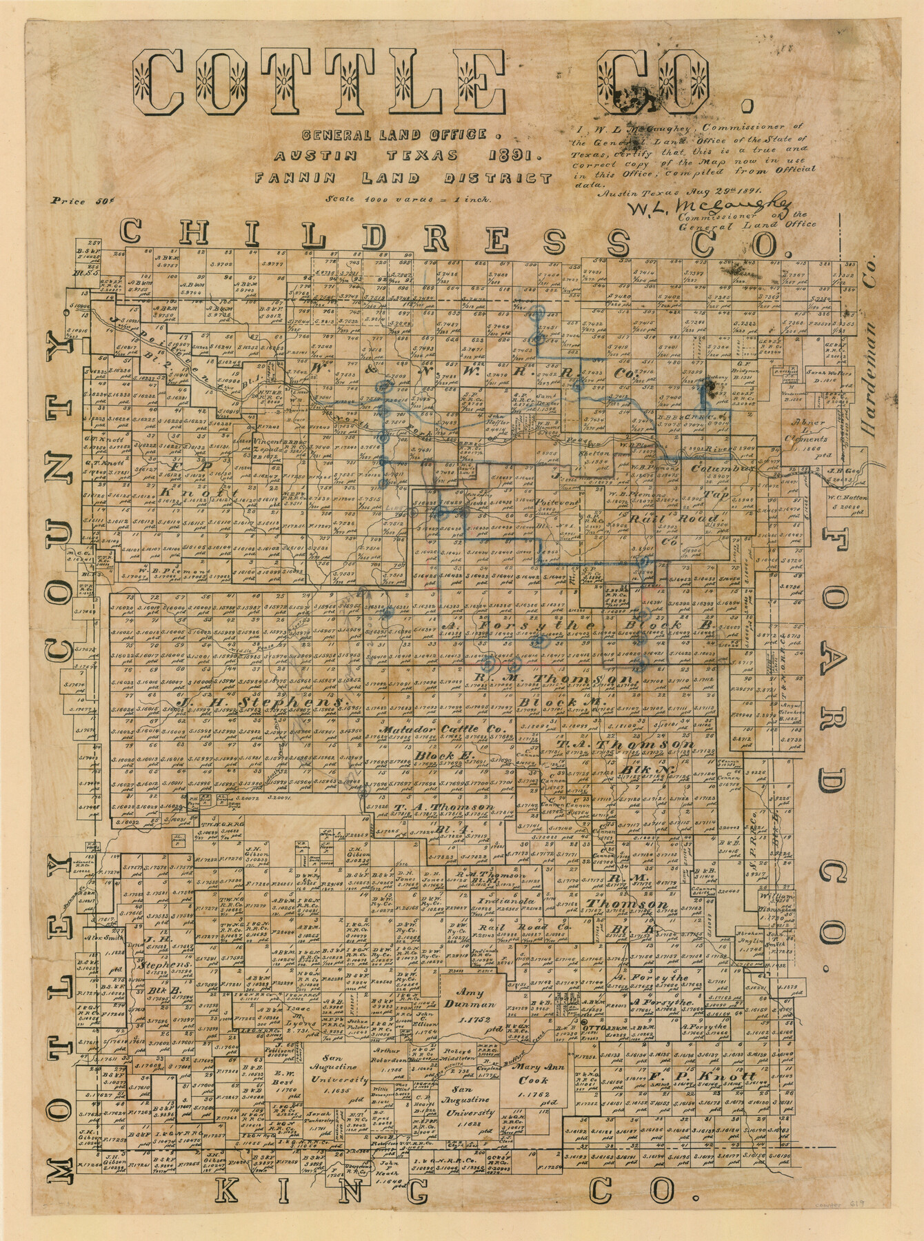
Cottle County, Texas
-
Map/Doc
619
-
Collection
Maddox Collection
-
Object Dates
8/29/1891 (Creation Date)
-
People and Organizations
General Land Office (Publisher)
W.L. McGaughey (GLO Commissioner)
-
Counties
Cottle
-
Subjects
County
-
Height x Width
23.1 x 17.0 inches
58.7 x 43.2 cm
-
Medium
paper, etching/engraving/lithograph
-
Scale
1" = 4000 varas
-
Comments
Conservation funded in 2011.
-
Features
North Fork of the Pease River
Middle Pease River
South Pease River
Autumn Creek
North Wichita or Bufford Creek
North Wichita Creek
Bufford Creek
Otto
Part of: Maddox Collection
Map of Part of the YL Ranch

Print $20.00
- Digital $50.00
Map of Part of the YL Ranch
1917
Size 29.1 x 27.3 inches
Map/Doc 4442
Medina County, Texas

Print $20.00
- Digital $50.00
Medina County, Texas
1879
Size 31.8 x 26.4 inches
Map/Doc 579
[Partial Map of Polk County, Texas]
![78452, [Partial Map of Polk County, Texas], Maddox Collection](https://historictexasmaps.com/wmedia_w700/maps/78452.tif.jpg)
Print $20.00
- Digital $50.00
[Partial Map of Polk County, Texas]
Size 16.6 x 12.3 inches
Map/Doc 78452
Map of lands owned by R.E. Montgomery in Martin and Andrews County, Texas

Print $20.00
- Digital $50.00
Map of lands owned by R.E. Montgomery in Martin and Andrews County, Texas
Size 20.0 x 24.5 inches
Map/Doc 75764
Map of Texas Compiled from Surveys recorded in the Land Office of Texas

Print $20.00
- Digital $50.00
Map of Texas Compiled from Surveys recorded in the Land Office of Texas
1841
Size 26.4 x 22.3 inches
Map/Doc 538
Map of Public Land on Mustang Island

Print $20.00
- Digital $50.00
Map of Public Land on Mustang Island
Size 21.9 x 17.5 inches
Map/Doc 82315
Map showing A. & N. W., Raymond Word #3, S.S. Hervey #496, and M. Farley #495 corrected to conform to the judgement in Cause #2888, Travis County District Court, State of Texas versus D. Sullivan, et al

Print $20.00
- Digital $50.00
Map showing A. & N. W., Raymond Word #3, S.S. Hervey #496, and M. Farley #495 corrected to conform to the judgement in Cause #2888, Travis County District Court, State of Texas versus D. Sullivan, et al
1915
Size 18.5 x 30.0 inches
Map/Doc 75812
Crane County, Texas

Print $20.00
- Digital $50.00
Crane County, Texas
1889
Size 22.5 x 18.0 inches
Map/Doc 721
Map of Kendall County, Texas

Print $20.00
- Digital $50.00
Map of Kendall County, Texas
1879
Size 20.3 x 20.6 inches
Map/Doc 533
Saline Ranch in Mason, Kimble and Menard Counties

Print $20.00
- Digital $50.00
Saline Ranch in Mason, Kimble and Menard Counties
1916
Size 28.2 x 27.1 inches
Map/Doc 75807
[Sketch showing surveys in Sutton and Val Verde Counties, Texas]
![10779, [Sketch showing surveys in Sutton and Val Verde Counties, Texas], Maddox Collection](https://historictexasmaps.com/wmedia_w700/maps/10779.tif.jpg)
Print $20.00
- Digital $50.00
[Sketch showing surveys in Sutton and Val Verde Counties, Texas]
1880
Size 28.0 x 14.5 inches
Map/Doc 10779
Throckmorton County, Texas

Print $20.00
- Digital $50.00
Throckmorton County, Texas
1880
Size 28.8 x 22.5 inches
Map/Doc 627
You may also like
[G. C. & S. F. Railroad Company, Block S]
![91330, [G. C. & S. F. Railroad Company, Block S], Twichell Survey Records](https://historictexasmaps.com/wmedia_w700/maps/91330-1.tif.jpg)
Print $2.00
- Digital $50.00
[G. C. & S. F. Railroad Company, Block S]
Size 8.6 x 6.0 inches
Map/Doc 91330
Right of Way & Track Map, St. Louis, Brownsville & Mexico Ry. operated by St. Louis, Brownsville & Mexico Ry. Co.

Print $40.00
- Digital $50.00
Right of Way & Track Map, St. Louis, Brownsville & Mexico Ry. operated by St. Louis, Brownsville & Mexico Ry. Co.
1919
Size 25.4 x 57.2 inches
Map/Doc 64621
Polk County Sketch File 12a

Print $4.00
- Digital $50.00
Polk County Sketch File 12a
Size 6.1 x 6.4 inches
Map/Doc 34148
Jeff Davis County Sketch File 48

Print $3.00
- Digital $50.00
Jeff Davis County Sketch File 48
2002
Size 14.0 x 8.5 inches
Map/Doc 82923
Hale County Sketch File 26

Print $40.00
- Digital $50.00
Hale County Sketch File 26
1911
Size 20.7 x 54.4 inches
Map/Doc 10471
Nueces County Rolled Sketch 128 A-E

Print $10.00
- Digital $50.00
Nueces County Rolled Sketch 128 A-E
1998
Size 11.0 x 8.5 inches
Map/Doc 41611
Brazoria County Sketch File 39

Print $8.00
- Digital $50.00
Brazoria County Sketch File 39
1933
Size 11.3 x 8.8 inches
Map/Doc 15045
Irion County Rolled Sketch 22

Print $20.00
- Digital $50.00
Irion County Rolled Sketch 22
1936
Size 24.3 x 39.9 inches
Map/Doc 6330
Dawson County Working Sketch 10

Print $20.00
- Digital $50.00
Dawson County Working Sketch 10
1944
Size 15.6 x 13.6 inches
Map/Doc 68554
Wilson County Working Sketch 3

Print $20.00
- Digital $50.00
Wilson County Working Sketch 3
1952
Size 33.6 x 33.2 inches
Map/Doc 72583
Goliad County Working Sketch 2

Print $20.00
- Digital $50.00
Goliad County Working Sketch 2
1916
Size 15.5 x 21.6 inches
Map/Doc 63192
Due Southwest over the Cotton Belt Route

Due Southwest over the Cotton Belt Route
1891
Map/Doc 96773