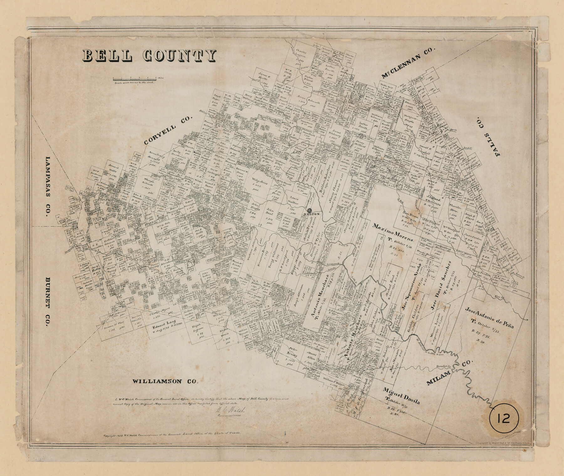
Bell County, Texas
-
Map/Doc
516
-
Collection
Maddox Collection
-
Object Dates
1879 (Creation Date)
-
People and Organizations
General Land Office (Publisher)
W. C. Walsh (GLO Commissioner)
August Gast & Co. (Lithographer)
-
Counties
Bell
-
Subjects
County
-
Height x Width
23.7 x 29.0 inches
60.2 x 73.7 cm
-
Medium
paper, etching/engraving/lithograph
-
Scale
1" = 4000 varas
-
Comments
Conservation funded by Friends of the Texas General Land Office in 2011.
"Lithographed by August Gast & Co's new process. St. Louis" -
Features
Bird Creek
Donahoe Creek
St. Andreas River
St. Andreas or Little River
Indian Creek
Little River
Salado River
Mill Creek
Lampasas River
Freeman Creek
South Fork of Elm Creek
Mitchell Creek
Bear Creek
Owl Creek
Friar Creek
Leon River
Leon Creek
Belton
Tremmier Creek
Reese Creek
Clear Creek
Noland Creek
North Fork of Noland Creek
Pond Creek
Deer Creek
Elm Creek
Cedar Creek
Cowhouse Creek
Flint Creek
Horse Creek
Stampede Creek
Part of: Maddox Collection
Aransas County, Texas

Print $20.00
- Digital $50.00
Aransas County, Texas
1880
Size 19.3 x 20.2 inches
Map/Doc 665
Map of Comal County, Texas

Print $20.00
- Digital $50.00
Map of Comal County, Texas
1879
Size 23.4 x 28.6 inches
Map/Doc 701
Map of Hays County, Texas

Print $20.00
- Digital $50.00
Map of Hays County, Texas
1880
Size 24.3 x 21.4 inches
Map/Doc 5029
Trinity County, Texas

Print $20.00
- Digital $50.00
Trinity County, Texas
1879
Size 15.8 x 23.8 inches
Map/Doc 761
Plat Showing Position of Hancock Tract and the City of Austin

Print $20.00
- Digital $50.00
Plat Showing Position of Hancock Tract and the City of Austin
Size 22.4 x 17.5 inches
Map/Doc 599
Smithville, Bastrop County, Texas

Print $3.00
- Digital $50.00
Smithville, Bastrop County, Texas
1895
Size 11.0 x 17.2 inches
Map/Doc 531
[Sketch of Surveys in Ward County, Texas]
![75767, [Sketch of Surveys in Ward County, Texas], Maddox Collection](https://historictexasmaps.com/wmedia_w700/maps/75767.tif.jpg)
Print $20.00
- Digital $50.00
[Sketch of Surveys in Ward County, Texas]
Size 9.7 x 37.1 inches
Map/Doc 75767
Bosque County, Texas

Print $20.00
- Digital $50.00
Bosque County, Texas
1879
Size 25.1 x 29.9 inches
Map/Doc 420
Map of Grimes County, Texas

Print $20.00
- Digital $50.00
Map of Grimes County, Texas
1880
Size 29.5 x 15.6 inches
Map/Doc 432
Map Representing the Original Locations of Various Surveys Deliniated Thereon

Print $40.00
- Digital $50.00
Map Representing the Original Locations of Various Surveys Deliniated Thereon
1890
Size 40.8 x 62.0 inches
Map/Doc 469
[Sketch of Plans and Bill of Material for 38' x 40' Texas Highway Dept. Warehouse]
![450, [Sketch of Plans and Bill of Material for 38' x 40' Texas Highway Dept. Warehouse], Maddox Collection](https://historictexasmaps.com/wmedia_w700/maps/450.tif.jpg)
Print $20.00
- Digital $50.00
[Sketch of Plans and Bill of Material for 38' x 40' Texas Highway Dept. Warehouse]
Size 23.7 x 22.8 inches
Map/Doc 450
Spence Addition Owned by L.N. Goldbeck and Herman Pressler - A Subdivision of Outlot 43, Division "O"

Print $20.00
- Digital $50.00
Spence Addition Owned by L.N. Goldbeck and Herman Pressler - A Subdivision of Outlot 43, Division "O"
1913
Size 15.5 x 12.8 inches
Map/Doc 83424
You may also like
Sterling County

Print $20.00
- Digital $50.00
Sterling County
1971
Size 44.7 x 33.4 inches
Map/Doc 73294

Starr County Sketch File 23

Print $16.00
- Digital $50.00
Starr County Sketch File 23
1922
Size 10.7 x 8.8 inches
Map/Doc 36919
Caldwell County Sketch File 1

Print $22.00
- Digital $50.00
Caldwell County Sketch File 1
Size 8.6 x 12.4 inches
Map/Doc 35825
Liberty County Sketch File 19

Print $6.00
- Digital $50.00
Liberty County Sketch File 19
1859
Size 13.6 x 9.4 inches
Map/Doc 29923
Jeff Davis County Sketch File 2a

Print $4.00
- Digital $50.00
Jeff Davis County Sketch File 2a
Size 8.3 x 3.3 inches
Map/Doc 27890
Lee County Working Sketch 22

Print $20.00
- Digital $50.00
Lee County Working Sketch 22
2010
Size 29.2 x 29.6 inches
Map/Doc 89271
Brown County Rolled Sketch 1

Print $20.00
- Digital $50.00
Brown County Rolled Sketch 1
1969
Size 15.4 x 22.1 inches
Map/Doc 5348
Sectional Map of Martin County, Texas

Print $3.00
- Digital $50.00
Sectional Map of Martin County, Texas
Size 9.6 x 12.1 inches
Map/Doc 91293
Map of Blanco County

Print $20.00
- Digital $50.00
Map of Blanco County
1862
Size 28.1 x 18.7 inches
Map/Doc 3303
Hudspeth County Rolled Sketch 75

Print $40.00
- Digital $50.00
Hudspeth County Rolled Sketch 75
1992
Size 35.6 x 48.9 inches
Map/Doc 9238
Medina County Sketch File 10

Print $20.00
- Digital $50.00
Medina County Sketch File 10
Size 18.0 x 22.6 inches
Map/Doc 12068