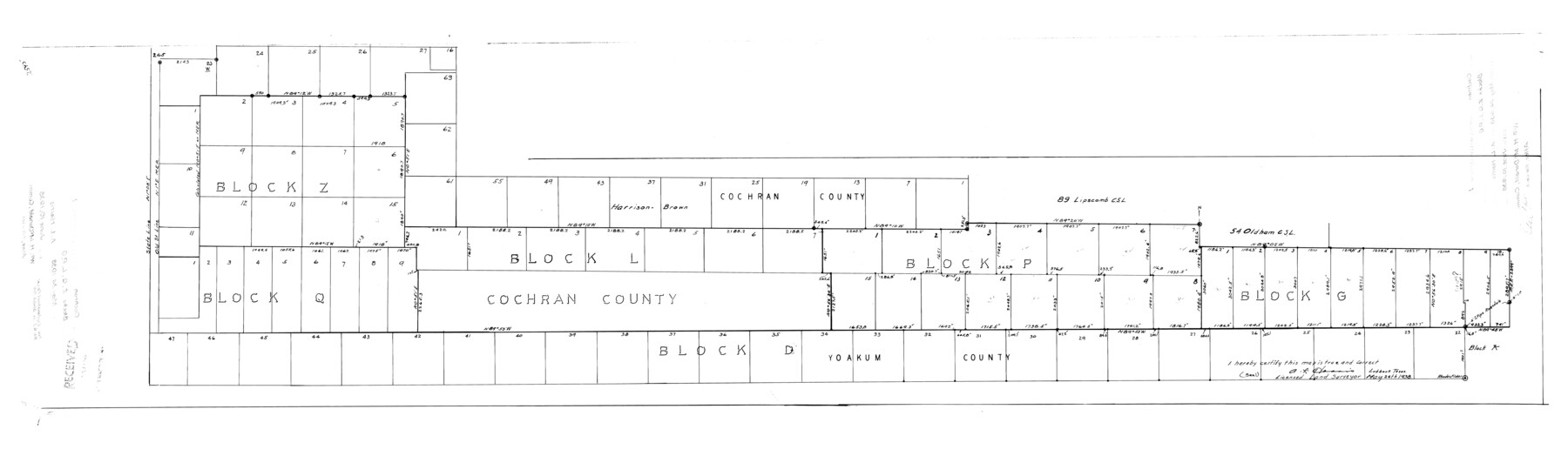
Cochran County Rolled Sketch 1
[Sketch of Blocks Z, Q, L, P, G, and D]
-
Map/Doc
8606
-
Collection
General Map Collection
-
Object Dates
5/24/1938 (Creation Date)
6/10/1938 (File Date)
-
People and Organizations
A.L. Harris (Surveyor/Engineer)
-
Counties
Cochran Yoakum
-
Subjects
Surveying Rolled Sketch
-
Height x Width
61.8 x 18.0 inches
157.0 x 45.7 cm
-
Comments
See Cochran County Sketch File 6 (18545) for explanation.
Related maps
Cochran County Sketch File 6

Print $10.00
- Digital $50.00
Cochran County Sketch File 6
1938
Size 11.2 x 8.6 inches
Map/Doc 18545
Part of: General Map Collection
Outer Continental Shelf Leasing Maps (Texas Offshore Operations)

Print $20.00
- Digital $50.00
Outer Continental Shelf Leasing Maps (Texas Offshore Operations)
Size 17.6 x 13.8 inches
Map/Doc 75844
Wheeler County

Print $20.00
- Digital $50.00
Wheeler County
1878
Size 18.5 x 16.6 inches
Map/Doc 4140
Throckmorton Co.

Print $20.00
- Digital $50.00
Throckmorton Co.
1898
Size 41.2 x 35.9 inches
Map/Doc 16895
Briscoe County Sketch File D

Print $40.00
- Digital $50.00
Briscoe County Sketch File D
1918
Size 25.8 x 22.9 inches
Map/Doc 11001
Bowie County Working Sketch 10b

Print $20.00
- Digital $50.00
Bowie County Working Sketch 10b
1956
Size 31.1 x 37.6 inches
Map/Doc 67414
Right of Way and Track Map, International & Gt. Northern Ry. Operated by the International & Gt. Northern Ry. Co., Gulf Division

Print $40.00
- Digital $50.00
Right of Way and Track Map, International & Gt. Northern Ry. Operated by the International & Gt. Northern Ry. Co., Gulf Division
1917
Size 25.1 x 56.6 inches
Map/Doc 64252
Travis County

Print $40.00
- Digital $50.00
Travis County
1880
Size 59.0 x 70.2 inches
Map/Doc 16902
Engineer's Office, Department of the Gulf Map No. 59, Texas prepared by order of Maj. Gen. N. P. Banks under direction of Capt. P. C. Hains, U. S. Engr. & Chief Engr., Dept. of the Gulf

Print $20.00
- Digital $50.00
Engineer's Office, Department of the Gulf Map No. 59, Texas prepared by order of Maj. Gen. N. P. Banks under direction of Capt. P. C. Hains, U. S. Engr. & Chief Engr., Dept. of the Gulf
1865
Size 18.2 x 27.5 inches
Map/Doc 72718
Real County Working Sketch 5

Print $20.00
- Digital $50.00
Real County Working Sketch 5
1924
Size 17.9 x 29.1 inches
Map/Doc 71897
Leon County Working Sketch 40

Print $20.00
- Digital $50.00
Leon County Working Sketch 40
1980
Size 31.4 x 20.5 inches
Map/Doc 70439
[Surveys in Power and Hewetson's Colony along the Blanco and Medina Rivers]
![46, [Surveys in Power and Hewetson's Colony along the Blanco and Medina Rivers], General Map Collection](https://historictexasmaps.com/wmedia_w700/maps/46.tif.jpg)
Print $20.00
- Digital $50.00
[Surveys in Power and Hewetson's Colony along the Blanco and Medina Rivers]
1834
Size 37.0 x 29.9 inches
Map/Doc 46
Jackson County Working Sketch 3

Print $20.00
- Digital $50.00
Jackson County Working Sketch 3
1941
Size 34.3 x 29.8 inches
Map/Doc 66451
You may also like
Bailey County Sketch File 2a

Print $6.00
- Digital $50.00
Bailey County Sketch File 2a
1892
Size 13.0 x 8.3 inches
Map/Doc 13935
Connected Map of Austin's Colony

Print $20.00
- Digital $50.00
Connected Map of Austin's Colony
1892
Size 47.5 x 43.0 inches
Map/Doc 76074
Travis County Appraisal District Plat Map 2_1002

Print $20.00
- Digital $50.00
Travis County Appraisal District Plat Map 2_1002
Size 21.4 x 26.5 inches
Map/Doc 94230
San Augustine County Working Sketch 3

Print $20.00
- Digital $50.00
San Augustine County Working Sketch 3
1934
Size 22.9 x 13.6 inches
Map/Doc 63690
Cherokee County Sketch File 3

Print $4.00
- Digital $50.00
Cherokee County Sketch File 3
1849
Size 7.5 x 11.0 inches
Map/Doc 18115
Llano County Working Sketch 5

Print $20.00
- Digital $50.00
Llano County Working Sketch 5
1961
Size 43.1 x 34.4 inches
Map/Doc 70623
Real County Working Sketch 19

Print $3.00
- Digital $50.00
Real County Working Sketch 19
1944
Size 12.0 x 10.4 inches
Map/Doc 71911
Jefferson County Working Sketch 34

Print $20.00
- Digital $50.00
Jefferson County Working Sketch 34
1981
Size 33.4 x 18.8 inches
Map/Doc 66578
Flight Mission No. CGI-1N, Frame 216, Cameron County

Print $20.00
- Digital $50.00
Flight Mission No. CGI-1N, Frame 216, Cameron County
1955
Size 18.5 x 22.2 inches
Map/Doc 84525
Atascosa County Sketch File 3c

Print $4.00
- Digital $50.00
Atascosa County Sketch File 3c
1858
Size 14.3 x 7.3 inches
Map/Doc 13743
Taylor County Rolled Sketch 21

Print $20.00
- Digital $50.00
Taylor County Rolled Sketch 21
Size 31.5 x 40.5 inches
Map/Doc 9985
[Texas, New Mexico Clark's Monument #26]
![91309, [Texas, New Mexico Clark's Monument #26], Twichell Survey Records](https://historictexasmaps.com/wmedia_w700/maps/91309-1.tif.jpg)
Print $3.00
- Digital $50.00
[Texas, New Mexico Clark's Monument #26]
1941
Size 16.1 x 7.4 inches
Map/Doc 91309