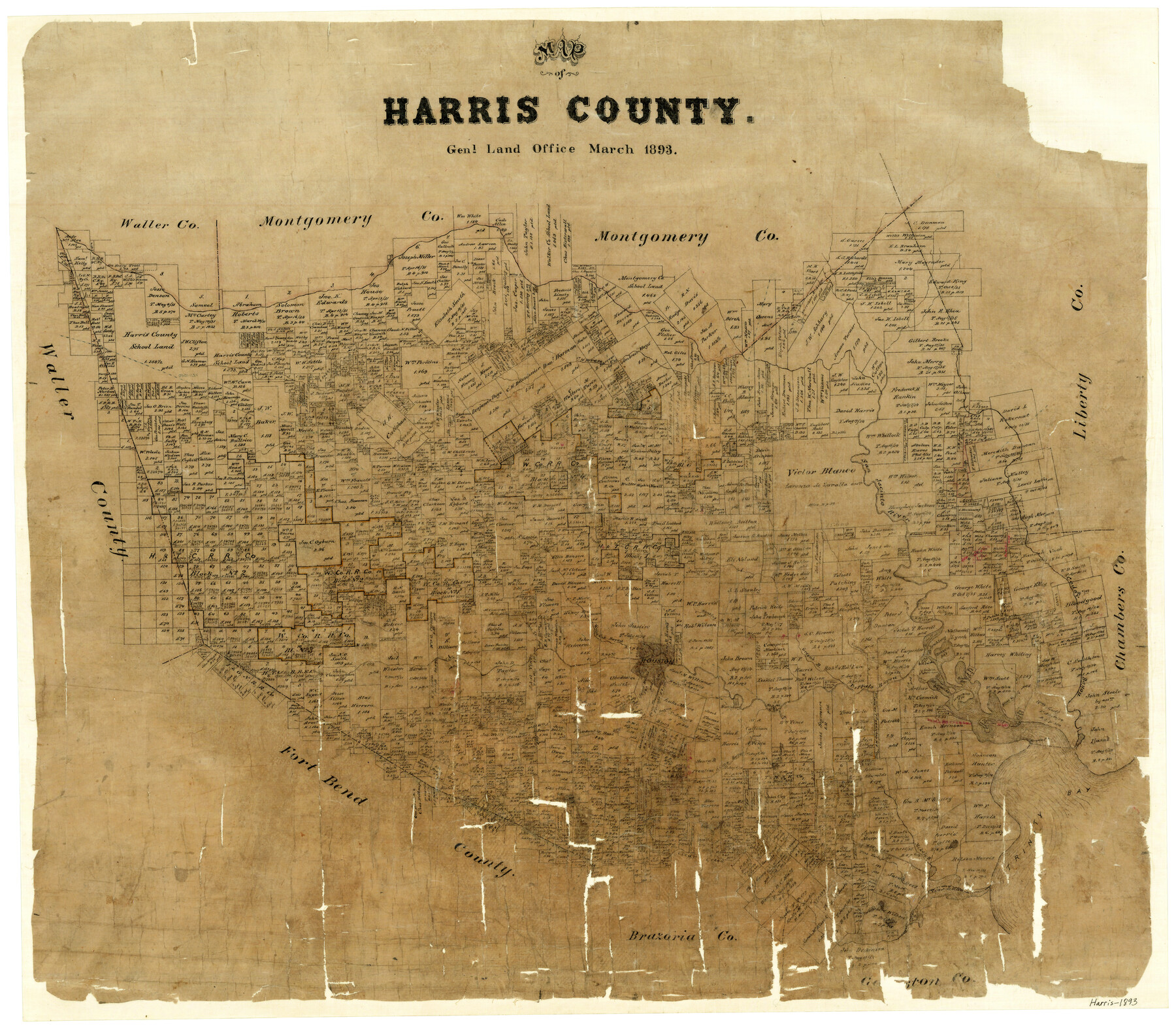
Map of Harris County
-
Map/Doc
3632
-
Collection
General Map Collection
-
Object Dates
1893 (Creation Date)
-
People and Organizations
Texas General Land Office (Publisher)
-
Counties
Harris
-
Subjects
County
-
Height x Width
29.7 x 33.8 inches
75.4 x 85.9 cm
-
Features
Morgan's Point
Cedar Bayou
Hog Island
Goose Creek
Spilman's Island
Burnets Bay
Scotts Bay
McCormicks Bay
Trinity Bay
Lynchburg
Middle Bayou
Sims Bayou
Clear Lake
San Jacinto
Cypress
Black Bayou
Willow Creek
Cypress Creek
San Jacinto Battleground
Bear Creek
Carpenter's Bayou
Vince's Bayou
Brays Bayou
Buffalo Bayou
Harrisburg
Green's Bayou
Hunting Bayou
Houston
White Oak Bayou
Clear Creek
Spring Creek
Hockley
San Jacinto River
Part of: General Map Collection
Van Zandt County Sketch File 35

Print $4.00
- Digital $50.00
Van Zandt County Sketch File 35
1862
Size 12.7 x 8.2 inches
Map/Doc 39474
Presidio County Rolled Sketch 47

Print $20.00
- Digital $50.00
Presidio County Rolled Sketch 47
1908
Size 30.8 x 32.2 inches
Map/Doc 7343
Karnes County Sketch File 6

Print $4.00
- Digital $50.00
Karnes County Sketch File 6
1858
Size 7.7 x 8.1 inches
Map/Doc 28557
[Sketch of the Robertson League on the Brazos River showing a conflict with T.J. Chambers]
![3178, [Sketch of the Robertson League on the Brazos River showing a conflict with T.J. Chambers], General Map Collection](https://historictexasmaps.com/wmedia_w700/maps/3178.tif.jpg)
Print $2.00
- Digital $50.00
[Sketch of the Robertson League on the Brazos River showing a conflict with T.J. Chambers]
1841
Size 7.6 x 12.6 inches
Map/Doc 3178
Grayson County Sketch File 3

Print $4.00
- Digital $50.00
Grayson County Sketch File 3
1855
Size 12.4 x 8.4 inches
Map/Doc 24460
King County Working Sketch 9

Print $20.00
- Digital $50.00
King County Working Sketch 9
1955
Size 34.1 x 22.7 inches
Map/Doc 70173
Orange County Sketch File 10

Print $4.00
- Digital $50.00
Orange County Sketch File 10
1876
Size 8.4 x 12.8 inches
Map/Doc 33317
Runnels County Sketch File 17

Print $6.00
Runnels County Sketch File 17
Size 11.0 x 13.6 inches
Map/Doc 35474
Brewster County Sketch File N-30

Print $6.00
- Digital $50.00
Brewster County Sketch File N-30
1969
Size 11.2 x 8.9 inches
Map/Doc 15708
[Jack District]
![1992, [Jack District], General Map Collection](https://historictexasmaps.com/wmedia_w700/maps/1992.tif.jpg)
Print $40.00
- Digital $50.00
[Jack District]
1880
Size 52.7 x 43.4 inches
Map/Doc 1992
Flight Mission No. CLL-3N, Frame 31, Willacy County

Print $20.00
- Digital $50.00
Flight Mission No. CLL-3N, Frame 31, Willacy County
1954
Size 18.5 x 22.2 inches
Map/Doc 87087
McMullen County Working Sketch 16

Print $20.00
- Digital $50.00
McMullen County Working Sketch 16
1940
Size 23.8 x 19.8 inches
Map/Doc 70717
You may also like
Brewster County Rolled Sketch 56

Print $20.00
- Digital $50.00
Brewster County Rolled Sketch 56
Size 43.1 x 37.1 inches
Map/Doc 8481
[Subdivision Plat of 80 acres]
![93074, [Subdivision Plat of 80 acres], Twichell Survey Records](https://historictexasmaps.com/wmedia_w700/maps/93074-1.tif.jpg)
Print $2.00
- Digital $50.00
[Subdivision Plat of 80 acres]
Size 10.6 x 6.3 inches
Map/Doc 93074
Map of San Antonio, Texas, Postal Delivery Units showing all boundary lines / Tourist Map of San Antonio showing points of interest and places of amusements, main thoroughfares and highways in and out of city and where they go / Business Section Map

Map of San Antonio, Texas, Postal Delivery Units showing all boundary lines / Tourist Map of San Antonio showing points of interest and places of amusements, main thoroughfares and highways in and out of city and where they go / Business Section Map
Size 18.0 x 24.0 inches
Map/Doc 95160

The Rand McNally New Commercial Atlas Map of Texas

Print $20.00
- Digital $50.00
The Rand McNally New Commercial Atlas Map of Texas
1917
Size 28.7 x 40.6 inches
Map/Doc 95850
Cass County Working Sketch 37

Print $20.00
- Digital $50.00
Cass County Working Sketch 37
1982
Size 26.8 x 31.8 inches
Map/Doc 67940
Yates Pool, Pecos County, Texas

Print $20.00
- Digital $50.00
Yates Pool, Pecos County, Texas
1928
Size 21.3 x 18.3 inches
Map/Doc 91623
Clay County Sketch File 44

Print $20.00
- Digital $50.00
Clay County Sketch File 44
Size 24.7 x 36.0 inches
Map/Doc 11096
Denton County Sketch File 17

Print $4.00
- Digital $50.00
Denton County Sketch File 17
1857
Size 12.7 x 8.4 inches
Map/Doc 20729
Brazos River, Darrington-Ramsey Farms Project

Print $20.00
- Digital $50.00
Brazos River, Darrington-Ramsey Farms Project
1930
Size 37.5 x 26.8 inches
Map/Doc 69677
Stephens County Working Sketch Graphic Index

Print $20.00
- Digital $50.00
Stephens County Working Sketch Graphic Index
1940
Size 41.1 x 39.4 inches
Map/Doc 76702
[Sketch showing Blocks B17-B29 and vicinity]
![89732, [Sketch showing Blocks B17-B29 and vicinity], Twichell Survey Records](https://historictexasmaps.com/wmedia_w700/maps/89732-1.tif.jpg)
Print $40.00
- Digital $50.00
[Sketch showing Blocks B17-B29 and vicinity]
Size 61.8 x 28.6 inches
Map/Doc 89732