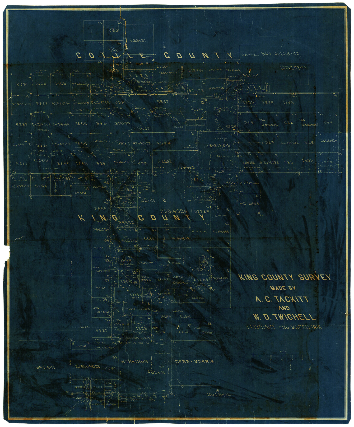
King County Survey made by A.C. Tackitt and W.D. Twichell
-
Map/Doc
5069
-
Collection
Maddox Collection
-
Object Dates
1916 (Creation Date)
2-3/1916 (Survey Date)
-
People and Organizations
W.D. Twichell (Surveyor/Engineer)
A.C. Tackitt (Surveyor/Engineer)
-
Counties
King Cottle
-
Height x Width
27.5 x 25.1 inches
69.9 x 63.8 cm
-
Medium
blueprint/diazo
-
Comments
Surveyed February and March 1916.
-
Features
Guthrie
South Fork of Wichita River
Willow Creek
North Wichita River
Buford's Branch [of North Wichita River]
Harper Young house
Part of: Maddox Collection
Revised Sectional Map No. 3 showing land surveys in counties of Loving, Reeves and Culberson and portions of Winkler, Ward, Pecos and Jeff Davis, Texas

Print $20.00
- Digital $50.00
Revised Sectional Map No. 3 showing land surveys in counties of Loving, Reeves and Culberson and portions of Winkler, Ward, Pecos and Jeff Davis, Texas
Size 19.0 x 24.7 inches
Map/Doc 4478
[Sketch Showing Loma Blanca , El Tule and San Antonio de Encinal Leagues in Brooks County, Texas]
![624, [Sketch Showing Loma Blanca , El Tule and San Antonio de Encinal Leagues in Brooks County, Texas], Maddox Collection](https://historictexasmaps.com/wmedia_w700/maps/00624.tif.jpg)
Print $3.00
- Digital $50.00
[Sketch Showing Loma Blanca , El Tule and San Antonio de Encinal Leagues in Brooks County, Texas]
Size 9.3 x 14.2 inches
Map/Doc 624
Wise County, Texas

Print $20.00
- Digital $50.00
Wise County, Texas
1871
Size 21.9 x 18.7 inches
Map/Doc 766
Sketch showing OX lands in the Yarbrough Pasture

Print $20.00
- Digital $50.00
Sketch showing OX lands in the Yarbrough Pasture
Size 14.0 x 25.2 inches
Map/Doc 4433
Frio County, Texas

Print $20.00
- Digital $50.00
Frio County, Texas
1870
Size 20.9 x 21.3 inches
Map/Doc 729
Part of original sketch of Block "H" W. & N. W. Ry. Co. Cottle County

Print $20.00
- Digital $50.00
Part of original sketch of Block "H" W. & N. W. Ry. Co. Cottle County
Size 14.3 x 15.6 inches
Map/Doc 613
Working Sketch in Dickens and Crosby Cos.

Print $20.00
- Digital $50.00
Working Sketch in Dickens and Crosby Cos.
1910
Size 36.1 x 24.8 inches
Map/Doc 10771
[Surveying Sketch of J.H. Vermillion, S.L. Fite, et al in Zapata County]
![698, [Surveying Sketch of J.H. Vermillion, S.L. Fite, et al in Zapata County], Maddox Collection](https://historictexasmaps.com/wmedia_w700/maps/0698.tif.jpg)
Print $20.00
- Digital $50.00
[Surveying Sketch of J.H. Vermillion, S.L. Fite, et al in Zapata County]
1914
Size 15.6 x 12.1 inches
Map/Doc 698
Map of Jefferson County, Texas

Print $20.00
- Digital $50.00
Map of Jefferson County, Texas
1879
Size 23.2 x 20.6 inches
Map/Doc 5054
[Sketch showing voting precincts in Jim Hogg and Brooks Counties]
![4497, [Sketch showing voting precincts in Jim Hogg and Brooks Counties], Maddox Collection](https://historictexasmaps.com/wmedia_w700/maps/4497-1.tif.jpg)
Print $20.00
- Digital $50.00
[Sketch showing voting precincts in Jim Hogg and Brooks Counties]
Size 10.1 x 18.2 inches
Map/Doc 4497
Plat of a portion of Buchel County, Texas

Print $20.00
- Digital $50.00
Plat of a portion of Buchel County, Texas
Size 16.0 x 26.2 inches
Map/Doc 82526
Marion County, Texas

Print $20.00
- Digital $50.00
Marion County, Texas
1879
Size 15.0 x 20.7 inches
Map/Doc 651
You may also like
Frio County Rolled Sketch 7

Print $20.00
- Digital $50.00
Frio County Rolled Sketch 7
Size 21.0 x 17.4 inches
Map/Doc 5918
Flight Mission No. DQN-5K, Frame 58, Calhoun County

Print $20.00
- Digital $50.00
Flight Mission No. DQN-5K, Frame 58, Calhoun County
1953
Size 15.5 x 15.3 inches
Map/Doc 84401
Ward County Rolled Sketch 19

Print $20.00
- Digital $50.00
Ward County Rolled Sketch 19
1949
Size 20.5 x 26.7 inches
Map/Doc 8161
Chambers County Boundary File 2

Print $18.00
- Digital $50.00
Chambers County Boundary File 2
Size 7.0 x 8.6 inches
Map/Doc 51240
Flight Mission No. BRA-7M, Frame 139, Jefferson County

Print $20.00
- Digital $50.00
Flight Mission No. BRA-7M, Frame 139, Jefferson County
1953
Size 18.7 x 22.4 inches
Map/Doc 85533
Brazoria County NRC Article 33.136 Sketch 16

Print $72.00
- Digital $50.00
Brazoria County NRC Article 33.136 Sketch 16
2014
Size 22.0 x 36.0 inches
Map/Doc 95037
Crane County Rolled Sketch 15

Print $40.00
- Digital $50.00
Crane County Rolled Sketch 15
1946
Size 27.2 x 49.5 inches
Map/Doc 8682
Real County Working Sketch 45

Print $20.00
- Digital $50.00
Real County Working Sketch 45
1955
Size 23.1 x 18.5 inches
Map/Doc 71937

Castro County Sketch File 4d

Print $4.00
- Digital $50.00
Castro County Sketch File 4d
Size 13.6 x 8.8 inches
Map/Doc 17471
Dimmit County Sketch File 9a

Print $4.00
- Digital $50.00
Dimmit County Sketch File 9a
Size 12.7 x 8.2 inches
Map/Doc 21073
Medina County Working Sketch 13

Print $20.00
- Digital $50.00
Medina County Working Sketch 13
1972
Size 31.5 x 39.0 inches
Map/Doc 70928