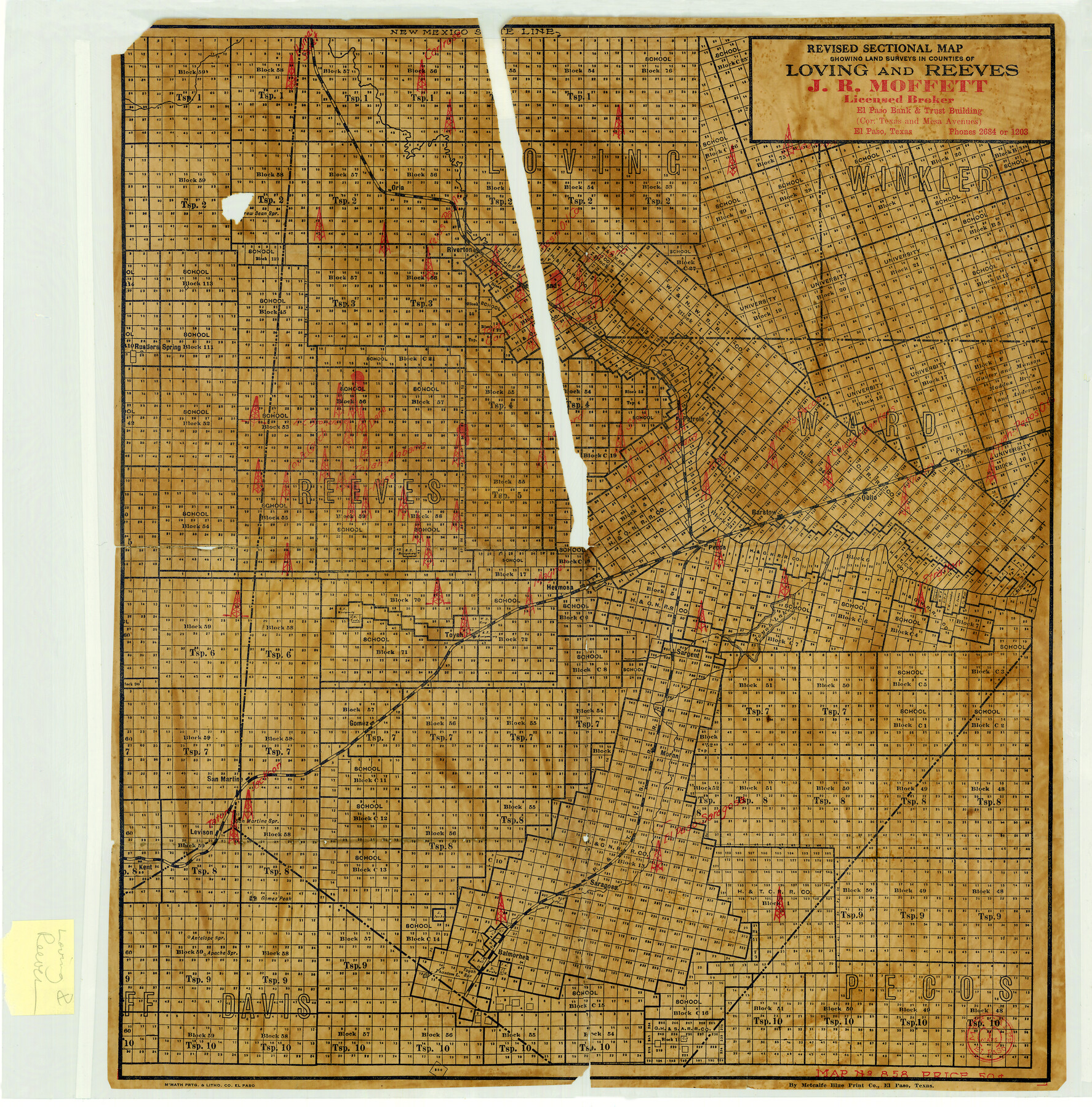
Revised Sectional Map showing land surveys in counties of Loving and Reeves
-
Map/Doc
5053
-
Collection
Maddox Collection
-
People and Organizations
J.R. Moffett (Publisher)
McMath Printing and Litho. (Printer)
J.R. Moffett (Agent)
-
Counties
Winkler Ward Jeff Davis Loving Reeves
-
Height x Width
18.0 x 17.7 inches
45.7 x 45.0 cm
-
Medium
paper, etching/engraving/lithograph
-
Features
Saragosa
P&TVS
Stratton
Pyote
Quito
Barstow
Pecos
Hermosa
Toyah
Gomez
San Martine
Levison
Kent
Balmorhea
El Paso-Saragosa
Moran
Sargent
Patrole
Orla
Toyah Lake
Phantom Lake
Toyah Spring
Antelope Spring
Apache Spring
Gomez Peak
San Martine Spring
[Sc]rew Bean Spring
Chicago Bankers
Carlrose
Pecos River
Leman
Texoiland
Basin Oil Co
Bell Well
Citizens
Toyah-Pecos
Texas Pacific
Rustlers Spring
Riverton
Victory
Homer Saxet
Trans-Pecos
King
Laura
Zone
Muse
Toyah-Alabama
Dare
KC Brokerage
Cox & Couch
Tatum
Jackson
Magnet
Part of: Maddox Collection
Oldham County, Texas

Print $20.00
- Digital $50.00
Oldham County, Texas
1880
Size 21.2 x 26.8 inches
Map/Doc 745
Map of Chambers County, Texas

Print $20.00
- Digital $50.00
Map of Chambers County, Texas
1879
Size 26.3 x 30.7 inches
Map/Doc 695
[Blocks CD, OP and GH in Crockett, Schleicher & Sutton Counties, Texas]
![75776, [Blocks CD, OP and GH in Crockett, Schleicher & Sutton Counties, Texas], Maddox Collection](https://historictexasmaps.com/wmedia_w700/maps/75776.tif.jpg)
Print $20.00
- Digital $50.00
[Blocks CD, OP and GH in Crockett, Schleicher & Sutton Counties, Texas]
Size 22.5 x 27.5 inches
Map/Doc 75776
Working Sketch of surveys in Mason, Kimble & Menard Counties

Print $20.00
- Digital $50.00
Working Sketch of surveys in Mason, Kimble & Menard Counties
1900
Size 32.1 x 42.4 inches
Map/Doc 75805
Montgomery County, Texas

Print $20.00
- Digital $50.00
Montgomery County, Texas
1880
Size 24.6 x 27.6 inches
Map/Doc 582
Jefferson County, Texas

Print $20.00
- Digital $50.00
Jefferson County, Texas
1879
Size 21.7 x 18.8 inches
Map/Doc 521
[Surveying Sketch of A. Forsythe Block B and R. M. Thomson Block M in Cottle County, Texas]
![523, [Surveying Sketch of A. Forsythe Block B and R. M. Thomson Block M in Cottle County, Texas], Maddox Collection](https://historictexasmaps.com/wmedia_w700/maps/523.tif.jpg)
Print $3.00
- Digital $50.00
[Surveying Sketch of A. Forsythe Block B and R. M. Thomson Block M in Cottle County, Texas]
1912
Size 11.0 x 15.8 inches
Map/Doc 523
[Z. C. Collier survey owned by Pease Estate, Hutchinson County]
![4472, [Z. C. Collier survey owned by Pease Estate, Hutchinson County], Maddox Collection](https://historictexasmaps.com/wmedia_w700/maps/4472-1.tif.jpg)
Print $20.00
- Digital $50.00
[Z. C. Collier survey owned by Pease Estate, Hutchinson County]
Size 19.0 x 20.8 inches
Map/Doc 4472
Saline Ranch in Mason, Kimble and Menard Counties

Print $20.00
- Digital $50.00
Saline Ranch in Mason, Kimble and Menard Counties
1916
Size 28.6 x 27.4 inches
Map/Doc 75808
Ward County, Texas

Print $20.00
- Digital $50.00
Ward County, Texas
1888
Size 20.2 x 25.5 inches
Map/Doc 657
[Sketch of San Antonio del Encinal, Hidalgo County, Texas]
![4457, [Sketch of San Antonio del Encinal, Hidalgo County, Texas], Maddox Collection](https://historictexasmaps.com/wmedia_w700/maps/4457-1.tif.jpg)
Print $20.00
- Digital $50.00
[Sketch of San Antonio del Encinal, Hidalgo County, Texas]
Size 12.1 x 27.1 inches
Map/Doc 4457
Map of Hays County, Texas

Print $20.00
- Digital $50.00
Map of Hays County, Texas
1880
Size 28.9 x 23.6 inches
Map/Doc 401
You may also like

[Movements & Objectives of the 143rd & 144th Infantry on October 13, 1918, Appendix L]
![94124, [Movements & Objectives of the 143rd & 144th Infantry on October 13, 1918, Appendix L], Non-GLO Digital Images](https://historictexasmaps.com/wmedia_w700/maps/94124-1.tif.jpg)
Print $20.00
[Movements & Objectives of the 143rd & 144th Infantry on October 13, 1918, Appendix L]
1918
Size 16.1 x 16.8 inches
Map/Doc 94124
Flight Mission No. CLL-1N, Frame 103, Willacy County

Print $20.00
- Digital $50.00
Flight Mission No. CLL-1N, Frame 103, Willacy County
1954
Size 18.4 x 22.1 inches
Map/Doc 87037
Wilbarger County Working Sketch 4

Print $20.00
- Digital $50.00
Wilbarger County Working Sketch 4
1925
Size 14.6 x 17.1 inches
Map/Doc 72542
Hopkins County Sketch File 15

Print $4.00
- Digital $50.00
Hopkins County Sketch File 15
Size 10.6 x 7.3 inches
Map/Doc 26711
Burnet County Boundary File 8

Print $88.00
- Digital $50.00
Burnet County Boundary File 8
Size 8.7 x 32.2 inches
Map/Doc 50908
Live Oak County Working Sketch 22

Print $40.00
- Digital $50.00
Live Oak County Working Sketch 22
1976
Size 63.1 x 31.9 inches
Map/Doc 70607
Dimmit County Working Sketch 7

Print $20.00
- Digital $50.00
Dimmit County Working Sketch 7
1927
Size 26.2 x 22.3 inches
Map/Doc 68668

Reagan County Working Sketch 2

Print $20.00
- Digital $50.00
Reagan County Working Sketch 2
1919
Size 28.5 x 19.6 inches
Map/Doc 71842
Flight Mission No. DQO-2K, Frame 100, Galveston County

Print $20.00
- Digital $50.00
Flight Mission No. DQO-2K, Frame 100, Galveston County
1952
Size 18.7 x 22.4 inches
Map/Doc 85027
[Right of Way Map, Belton Branch of the M.K.&T. RR.]
![64223, [Right of Way Map, Belton Branch of the M.K.&T. RR.], General Map Collection](https://historictexasmaps.com/wmedia_w700/maps/64223.tif.jpg)
Print $20.00
- Digital $50.00
[Right of Way Map, Belton Branch of the M.K.&T. RR.]
1896
Size 21.7 x 7.2 inches
Map/Doc 64223