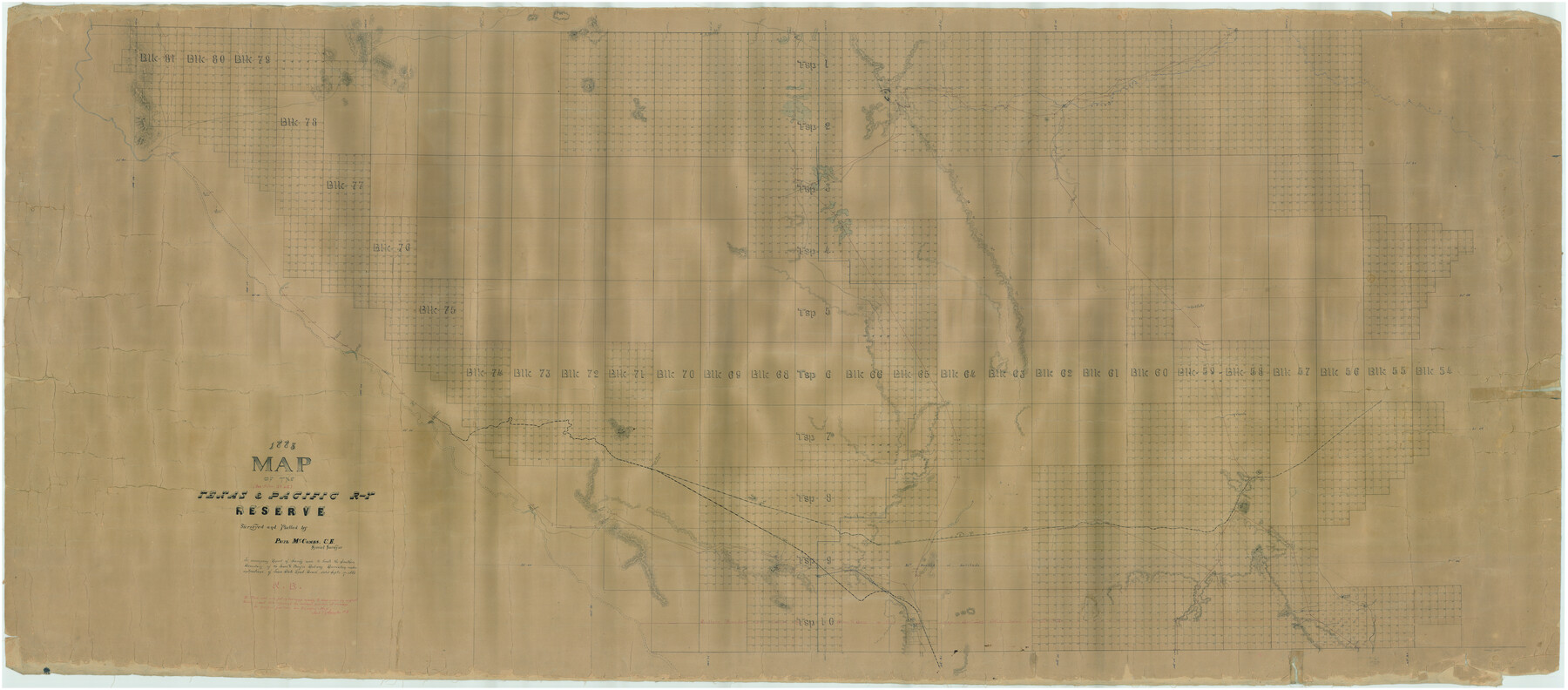
1882 Map of the Texas & Pacific R-Y Reserve
Z-1-9
-
Map/Doc
2299
-
Collection
General Map Collection
-
Object Dates
1888 (Creation Date)
-
People and Organizations
Paul McCombs (Surveyor/Engineer)
-
Subjects
Texas and Pacific Railroad
-
Height x Width
95.6 x 42.5 inches
242.8 x 108.0 cm
-
Comments
This map accompanies report of survey to locate the southern boundary of Texas and Pacific Railway reservation under instructions of Texas State Land Board, September 17, 1883.
Adopted by Glen Sample Ely and conservation funded in 2006.
This map is a digital composite of 83559, 83560 and 83561.
Related maps
1882 Map of the Texas & Pacific R-Y Reserve

Print $20.00
- Digital $50.00
1882 Map of the Texas & Pacific R-Y Reserve
1887
Size 44.5 x 31.7 inches
Map/Doc 83559
1882 Map of the Texas & Pacific R-Y Reserve

Print $20.00
- Digital $50.00
1882 Map of the Texas & Pacific R-Y Reserve
1887
Size 44.1 x 42.1 inches
Map/Doc 83560
1882 Map of the Texas & Pacific R-Y Reserve

Print $20.00
- Digital $50.00
1882 Map of the Texas & Pacific R-Y Reserve
1887
Size 44.6 x 29.8 inches
Map/Doc 83561
Part of: General Map Collection
Township 6 South Range 13 West, South Western District, Louisiana

Print $20.00
- Digital $50.00
Township 6 South Range 13 West, South Western District, Louisiana
1879
Size 19.6 x 24.8 inches
Map/Doc 65886
Stonewall County Rolled Sketch 7

Print $20.00
- Digital $50.00
Stonewall County Rolled Sketch 7
1890
Size 16.6 x 37.9 inches
Map/Doc 7864
Intracoastal Waterway in Texas - Corpus Christi to Point Isabel including Arroyo Colorado to Mo. Pac. R.R. Bridge Near Harlingen

Print $20.00
- Digital $50.00
Intracoastal Waterway in Texas - Corpus Christi to Point Isabel including Arroyo Colorado to Mo. Pac. R.R. Bridge Near Harlingen
1933
Size 28.0 x 40.7 inches
Map/Doc 61848
Flight Mission No. BRA-7M, Frame 34, Jefferson County

Print $20.00
- Digital $50.00
Flight Mission No. BRA-7M, Frame 34, Jefferson County
1953
Size 18.6 x 22.3 inches
Map/Doc 85485
Pecos County Sketch File 100

Print $20.00
- Digital $50.00
Pecos County Sketch File 100
1959
Size 16.4 x 29.9 inches
Map/Doc 12186
[Plat of Location and Right of Way from El Paso, Tex. To New Mexico Line, Rio Grande and El Paso R. R.]
![64084, [Plat of Location and Right of Way from El Paso, Tex. To New Mexico Line, Rio Grande and El Paso R. R.], General Map Collection](https://historictexasmaps.com/wmedia_w700/maps/64084.tif.jpg)
Print $20.00
- Digital $50.00
[Plat of Location and Right of Way from El Paso, Tex. To New Mexico Line, Rio Grande and El Paso R. R.]
Size 22.7 x 46.8 inches
Map/Doc 64084

Flight Mission No. CUG-1P, Frame 112, Kleberg County

Print $20.00
- Digital $50.00
Flight Mission No. CUG-1P, Frame 112, Kleberg County
1956
Size 18.5 x 22.3 inches
Map/Doc 86162
Brewster County Sketch File N-3

Print $6.00
- Digital $50.00
Brewster County Sketch File N-3
1882
Size 8.6 x 7.6 inches
Map/Doc 15589
Potter County Rolled Sketch 13

Print $20.00
- Digital $50.00
Potter County Rolled Sketch 13
2004
Size 18.7 x 23.2 inches
Map/Doc 82477
Burnet County Boundary File 4

Print $30.00
- Digital $50.00
Burnet County Boundary File 4
Size 8.8 x 8.1 inches
Map/Doc 50872
Montgomery County Sketch File 3

Print $12.00
- Digital $50.00
Montgomery County Sketch File 3
1846
Size 4.5 x 8.3 inches
Map/Doc 31770
You may also like
Gaines County Working Sketch 9

Print $40.00
- Digital $50.00
Gaines County Working Sketch 9
1951
Size 75.2 x 20.8 inches
Map/Doc 69309
Coleman County Sketch File 47

Print $12.00
- Digital $50.00
Coleman County Sketch File 47
1897
Size 14.1 x 8.6 inches
Map/Doc 18793
Flight Mission No. BRA-8M, Frame 68, Jefferson County

Print $20.00
- Digital $50.00
Flight Mission No. BRA-8M, Frame 68, Jefferson County
1953
Size 18.6 x 22.4 inches
Map/Doc 85588
The Republic County of Galveston. Created, May 15, 1838

Print $20.00
The Republic County of Galveston. Created, May 15, 1838
2020
Size 14.7 x 21.9 inches
Map/Doc 96143
Concho County Working Sketch 14

Print $20.00
- Digital $50.00
Concho County Working Sketch 14
1955
Size 24.7 x 21.0 inches
Map/Doc 68196
Map of Jackson County Texas

Print $20.00
- Digital $50.00
Map of Jackson County Texas
1840
Size 29.6 x 23.2 inches
Map/Doc 3708
Greer County Sketch File 7

Print $40.00
- Digital $50.00
Greer County Sketch File 7
Size 12.8 x 17.5 inches
Map/Doc 24526
Colton's new map of the state of Texas, the Indian Territory and adjoining portions of New Mexico, Louisiana, and Arkansas

Print $20.00
Colton's new map of the state of Texas, the Indian Territory and adjoining portions of New Mexico, Louisiana, and Arkansas
1872
Size 31.1 x 36.6 inches
Map/Doc 93579
Current Miscellaneous File 26

Print $4.00
- Digital $50.00
Current Miscellaneous File 26
1952
Size 10.7 x 8.3 inches
Map/Doc 73907
Galveston to Rio Grande

Print $20.00
- Digital $50.00
Galveston to Rio Grande
1946
Size 44.8 x 36.9 inches
Map/Doc 69953
Houston County Working Sketch 9

Print $20.00
- Digital $50.00
Houston County Working Sketch 9
1939
Size 28.9 x 31.3 inches
Map/Doc 66239
[Sketch of Berry Doolittle, C. B. Emmons. R. D. Price and other surveys]
![90213, [Sketch of Berry Doolittle, C. B. Emmons. R. D. Price and other surveys], Twichell Survey Records](https://historictexasmaps.com/wmedia_w700/maps/90213-1.tif.jpg)
Print $20.00
- Digital $50.00
[Sketch of Berry Doolittle, C. B. Emmons. R. D. Price and other surveys]
Size 25.8 x 19.7 inches
Map/Doc 90213