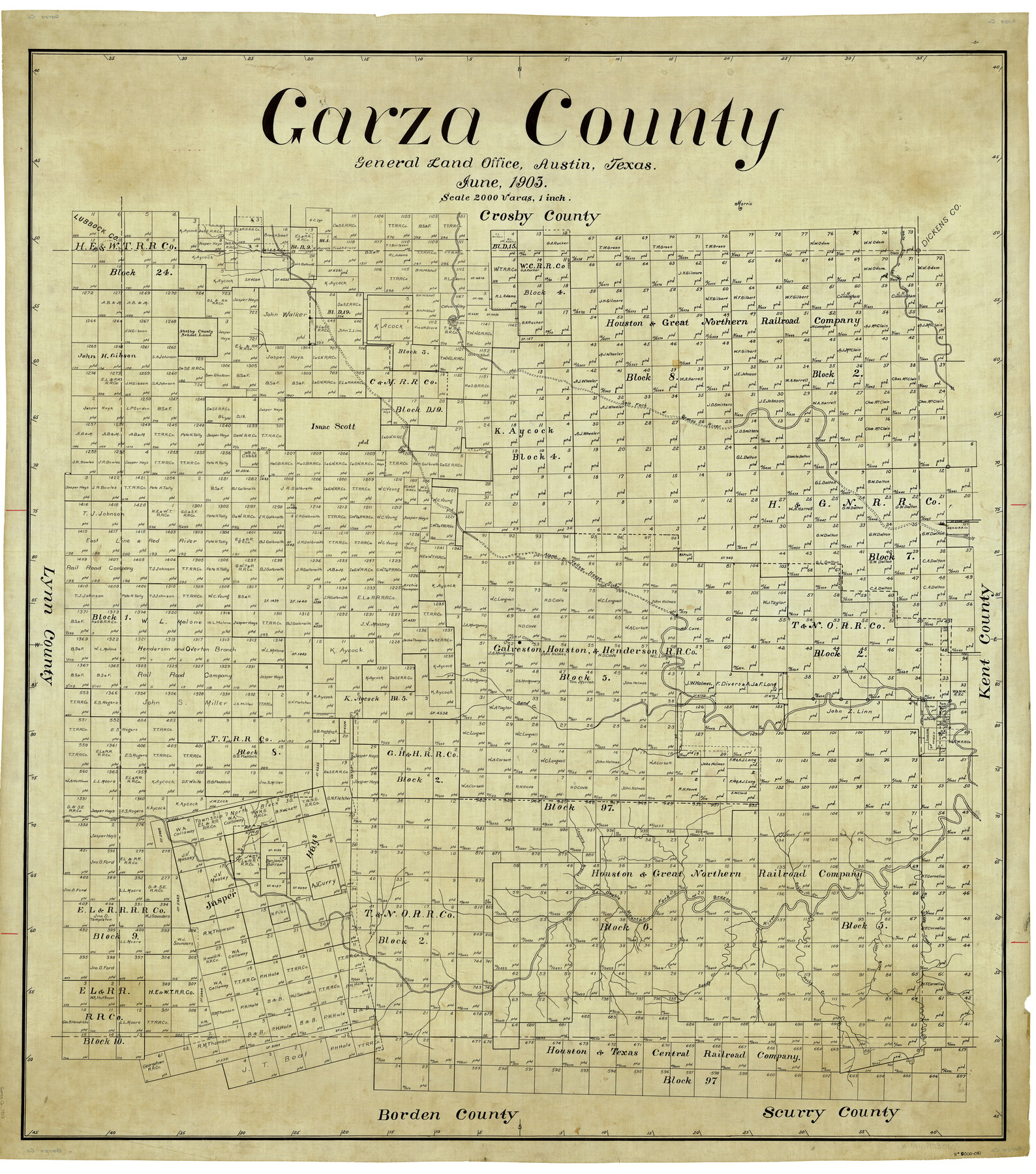
Garza County
-
Map/Doc
4955
-
Collection
General Map Collection
-
Object Dates
1903 (Creation Date)
-
People and Organizations
Texas General Land Office (Publisher)
-
Counties
Garza
-
Subjects
County
-
Height x Width
42.1 x 37.1 inches
106.9 x 94.2 cm
Part of: General Map Collection
Frio County Rolled Sketch 22

Print $20.00
- Digital $50.00
Frio County Rolled Sketch 22
1962
Size 16.4 x 24.6 inches
Map/Doc 5923
Burleson County Working Sketch 24

Print $20.00
- Digital $50.00
Burleson County Working Sketch 24
1980
Size 18.5 x 35.9 inches
Map/Doc 67743
Brewster County Sketch File NS-13

Print $4.00
- Digital $50.00
Brewster County Sketch File NS-13
1955
Size 11.1 x 8.8 inches
Map/Doc 16220

Gregg County Rolled Sketch FB

Print $84.00
- Digital $50.00
Gregg County Rolled Sketch FB
1932
Size 25.2 x 56.7 inches
Map/Doc 9326
Webb County Working Sketch 17

Print $20.00
- Digital $50.00
Webb County Working Sketch 17
1923
Size 13.0 x 20.5 inches
Map/Doc 72382
Parker County Working Sketch 2

Print $20.00
- Digital $50.00
Parker County Working Sketch 2
1920
Map/Doc 71452
Robertson County Sketch File 12

Print $18.00
Robertson County Sketch File 12
1987
Size 11.4 x 8.8 inches
Map/Doc 35404
Jackson County Sketch File 30

Print $52.00
- Digital $50.00
Jackson County Sketch File 30
1944
Size 14.2 x 8.5 inches
Map/Doc 27730
Nueces County Rolled Sketch 115

Print $215.00
Nueces County Rolled Sketch 115
1992
Size 24.2 x 35.2 inches
Map/Doc 7126
Rusk County Sketch File 43

Print $20.00
Rusk County Sketch File 43
1951
Size 23.5 x 26.6 inches
Map/Doc 12278
Nacogdoches County

Print $20.00
- Digital $50.00
Nacogdoches County
1950
Size 45.4 x 41.6 inches
Map/Doc 77381
You may also like
Working Sketch of Central State Prison Farm, Fort Bend Co., Texas

Print $20.00
- Digital $50.00
Working Sketch of Central State Prison Farm, Fort Bend Co., Texas
Size 38.9 x 16.0 inches
Map/Doc 62996
Map Showing Colonel A.W. Doniphan's Route through the States of New Mexico, Chihuahua and Coahuila

Print $20.00
Map Showing Colonel A.W. Doniphan's Route through the States of New Mexico, Chihuahua and Coahuila
1847
Size 16.9 x 14.0 inches
Map/Doc 79729
The Republic County of Jackson. Boundaries Defined, December 29, 1837

Print $20.00
The Republic County of Jackson. Boundaries Defined, December 29, 1837
2020
Size 15.6 x 21.8 inches
Map/Doc 96184
1988 Land Use - El Paso, Ciudad Juarez and Vicinity

Print $20.00
- Digital $50.00
1988 Land Use - El Paso, Ciudad Juarez and Vicinity
1988
Size 34.2 x 25.1 inches
Map/Doc 87369
Aransas County Sketch File 7

Print $4.00
- Digital $50.00
Aransas County Sketch File 7
Size 12.7 x 7.9 inches
Map/Doc 13112
Bowie County Sketch File 4

Print $4.00
- Digital $50.00
Bowie County Sketch File 4
Size 10.8 x 8.4 inches
Map/Doc 14835
Map of the City of Barry, John McGowan & J.B. & A. Adams Surveys, Navarro County, Texas

Print $20.00
- Digital $50.00
Map of the City of Barry, John McGowan & J.B. & A. Adams Surveys, Navarro County, Texas
1958
Size 28.4 x 25.4 inches
Map/Doc 94015
Pecos County Sketch File 13

Print $20.00
- Digital $50.00
Pecos County Sketch File 13
Size 22.7 x 18.8 inches
Map/Doc 12156
Dimmit County Working Sketch 35

Print $20.00
- Digital $50.00
Dimmit County Working Sketch 35
1961
Size 22.4 x 24.4 inches
Map/Doc 68696
Jefferson County Rolled Sketch 48A

Print $20.00
- Digital $50.00
Jefferson County Rolled Sketch 48A
1964
Size 28.4 x 28.1 inches
Map/Doc 6404
El Paso County Working Sketch 39

Print $20.00
- Digital $50.00
El Paso County Working Sketch 39
1984
Size 45.7 x 37.1 inches
Map/Doc 69061
Maverick County Sketch File 3

Print $40.00
- Digital $50.00
Maverick County Sketch File 3
Size 18.3 x 11.6 inches
Map/Doc 31033