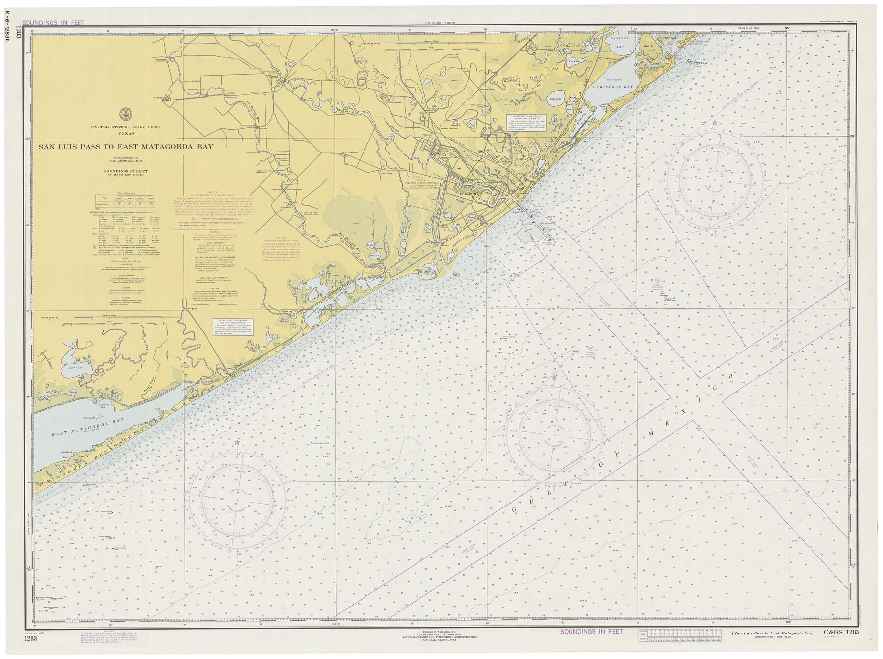
San Luis Pass to East Matagorda Bay
K-6-1283d
-
Map/Doc
69967
-
Collection
General Map Collection
-
Object Dates
4/1/1972 (Creation Date)
-
Counties
Galveston Matagorda Brazoria
-
Subjects
Nautical Charts
-
Height x Width
34.7 x 47.2 inches
88.1 x 119.9 cm
Part of: General Map Collection
Harris County Historic Topographic 2

Print $20.00
- Digital $50.00
Harris County Historic Topographic 2
1916
Size 29.5 x 22.7 inches
Map/Doc 65812
Coryell County Boundary File 1c

Print $6.00
- Digital $50.00
Coryell County Boundary File 1c
Size 10.2 x 8.1 inches
Map/Doc 51901
Blanco County Working Sketch 17

Print $20.00
- Digital $50.00
Blanco County Working Sketch 17
1954
Size 31.6 x 30.3 inches
Map/Doc 67377
Pecos County Sketch File 1

Print $20.00
- Digital $50.00
Pecos County Sketch File 1
Size 8.9 x 4.0 inches
Map/Doc 33642
Floyd County Sketch File 28

Print $20.00
- Digital $50.00
Floyd County Sketch File 28
Size 17.4 x 18.6 inches
Map/Doc 11487
Flight Mission No. DAH-17M, Frame 22, Orange County

Print $20.00
- Digital $50.00
Flight Mission No. DAH-17M, Frame 22, Orange County
1953
Size 18.8 x 22.6 inches
Map/Doc 86885
Fayette County

Print $40.00
- Digital $50.00
Fayette County
1978
Size 43.6 x 56.1 inches
Map/Doc 95496
Coleman County Sketch File 28

Print $6.00
- Digital $50.00
Coleman County Sketch File 28
1873
Size 10.2 x 15.8 inches
Map/Doc 18716
Webb County Working Sketch 92

Print $20.00
- Digital $50.00
Webb County Working Sketch 92
1988
Size 30.6 x 37.0 inches
Map/Doc 72459
Galveston County Rolled Sketch 48

Print $20.00
- Digital $50.00
Galveston County Rolled Sketch 48
2004
Size 24.8 x 36.8 inches
Map/Doc 83421
Grayson County Sketch File 6

Print $8.00
- Digital $50.00
Grayson County Sketch File 6
Size 12.9 x 8.2 inches
Map/Doc 24466
Smith County Rolled Sketch 6A2

Print $40.00
- Digital $50.00
Smith County Rolled Sketch 6A2
1934
Size 48.7 x 36.7 inches
Map/Doc 10702
You may also like
Hardeman Co[unty], Texas
![88946, Hardeman Co[unty], Texas, Library of Congress](https://historictexasmaps.com/wmedia_w700/maps/88946.tif.jpg)
Print $20.00
Hardeman Co[unty], Texas
1880
Size 27.8 x 23.7 inches
Map/Doc 88946
Maps of Gulf Intracoastal Waterway, Texas - Sabine River to the Rio Grande and connecting waterways including ship channels

Print $20.00
- Digital $50.00
Maps of Gulf Intracoastal Waterway, Texas - Sabine River to the Rio Grande and connecting waterways including ship channels
1966
Size 14.4 x 22.2 inches
Map/Doc 61943
Bandera County Working Sketch 27

Print $20.00
- Digital $50.00
Bandera County Working Sketch 27
1950
Size 15.0 x 17.1 inches
Map/Doc 67623
The Republic County of Milam. Proposed, Late Fall 1837

Print $20.00
The Republic County of Milam. Proposed, Late Fall 1837
2020
Size 19.9 x 21.7 inches
Map/Doc 96225
Presidio County Rolled Sketch 91

Print $20.00
- Digital $50.00
Presidio County Rolled Sketch 91
Size 15.1 x 29.4 inches
Map/Doc 7376
Fractional Township No. 10 South Range No. 26 East of the Indian Meridian, Indian Territory

Print $20.00
- Digital $50.00
Fractional Township No. 10 South Range No. 26 East of the Indian Meridian, Indian Territory
1897
Size 19.2 x 24.3 inches
Map/Doc 75245
Nolan County Sketch File 17

Print $6.00
- Digital $50.00
Nolan County Sketch File 17
1940
Size 17.9 x 10.1 inches
Map/Doc 32487
Flight Mission No. DIX-7P, Frame 93, Aransas County

Print $20.00
- Digital $50.00
Flight Mission No. DIX-7P, Frame 93, Aransas County
1956
Size 18.6 x 22.6 inches
Map/Doc 83887
Pocket Map of the State of Texas reduced from their original map of the State and drawn by Chas. W. Pressler and A. B. Langermann

Print $20.00
Pocket Map of the State of Texas reduced from their original map of the State and drawn by Chas. W. Pressler and A. B. Langermann
1879
Size 24.4 x 26.3 inches
Map/Doc 76208
Lipscomb County Boundary File 14b

Print $60.00
- Digital $50.00
Lipscomb County Boundary File 14b
Size 7.3 x 8.7 inches
Map/Doc 56370
Tom Green County Working Sketch 13

Print $20.00
- Digital $50.00
Tom Green County Working Sketch 13
1981
Size 34.3 x 26.4 inches
Map/Doc 69382
Hudspeth County Sketch File 45

Print $38.00
- Digital $50.00
Hudspeth County Sketch File 45
1982
Size 11.2 x 8.8 inches
Map/Doc 27030