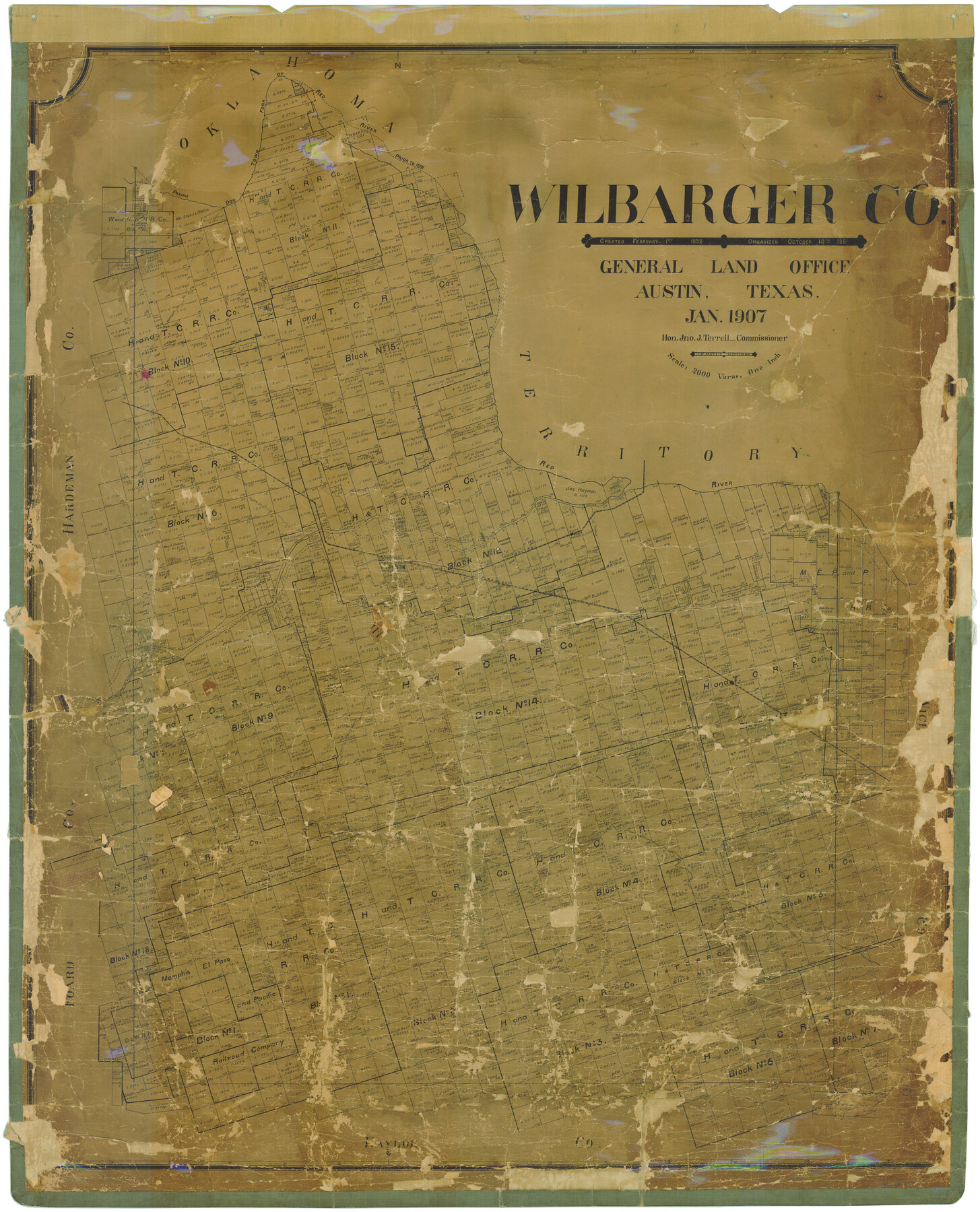
Wilbarger Co.
-
Map/Doc
16927
-
Collection
General Map Collection
-
Object Dates
1/1907 (Creation Date)
-
People and Organizations
John J. Terrell (GLO Commissioner)
Jourdan W. Morris (Draftsman)
-
Counties
Wilbarger
-
Subjects
County
-
Height x Width
49.0 x 39.3 inches
124.5 x 99.8 cm
-
Comments
Help Save Texas History - Adopt Me!
-
Features
Turkey Creek
Minnie's Creek
BE&T
Red River
Ennis Creek
Dugan Creek
Kingola
Denkin's Springs
Big Wichita River
Sunflower Creek
Beaver Creek
Rocky Creek
Boggy Creek
Prairie Dog Town Fork of Red River
Paradise Creek
Pool Creek
Harrold
North Fork of Moore's Creek
Plum Creek
Vernon
FW&DC
Farmer's Branch [of Red River]
Pease River
Wild Cat Creek
Buffalo Creek
Wanderers Creek
Part of: General Map Collection
Orange County NRC Article 33.136 Sketch 3

Print $16.00
- Digital $50.00
Orange County NRC Article 33.136 Sketch 3
2011
Size 11.0 x 8.5 inches
Map/Doc 93267
Briscoe County Working Sketch Graphic Index

Print $20.00
- Digital $50.00
Briscoe County Working Sketch Graphic Index
1930
Size 43.8 x 37.4 inches
Map/Doc 76478
United States - Gulf Coast Texas - Northern part of Laguna Madre

Print $20.00
- Digital $50.00
United States - Gulf Coast Texas - Northern part of Laguna Madre
1941
Size 27.2 x 18.4 inches
Map/Doc 72935
Swisher County

Print $20.00
- Digital $50.00
Swisher County
1879
Size 20.9 x 18.7 inches
Map/Doc 4063
Flight Mission No. DQN-1K, Frame 69, Calhoun County

Print $20.00
- Digital $50.00
Flight Mission No. DQN-1K, Frame 69, Calhoun County
1953
Size 18.5 x 22.2 inches
Map/Doc 84156
Culberson County Working Sketch 49

Print $40.00
- Digital $50.00
Culberson County Working Sketch 49
1972
Size 49.2 x 37.6 inches
Map/Doc 68503
San Jacinto County

Print $20.00
- Digital $50.00
San Jacinto County
1949
Size 43.5 x 39.1 inches
Map/Doc 77415
Flight Mission No. CRE-1R, Frame 134, Jackson County

Print $20.00
- Digital $50.00
Flight Mission No. CRE-1R, Frame 134, Jackson County
1956
Size 16.2 x 16.0 inches
Map/Doc 85342
Carson County Boundary File 5 and 5a

Print $50.00
- Digital $50.00
Carson County Boundary File 5 and 5a
Size 8.8 x 4.4 inches
Map/Doc 51134
Nueces County Rolled Sketch 40

Print $101.00
- Digital $50.00
Nueces County Rolled Sketch 40
1962
Size 10.3 x 15.3 inches
Map/Doc 47850
Runnels County Rolled Sketch 36

Print $40.00
- Digital $50.00
Runnels County Rolled Sketch 36
1950
Size 66.6 x 45.0 inches
Map/Doc 9869
Brazoria County Working Sketch 21

Print $20.00
- Digital $50.00
Brazoria County Working Sketch 21
1954
Size 41.5 x 41.8 inches
Map/Doc 67506
You may also like
Flight Mission No. DAG-21K, Frame 39, Matagorda County

Print $20.00
- Digital $50.00
Flight Mission No. DAG-21K, Frame 39, Matagorda County
1952
Size 18.6 x 22.3 inches
Map/Doc 86406
Terrell County Rolled Sketch 54

Print $20.00
- Digital $50.00
Terrell County Rolled Sketch 54
Size 18.8 x 22.6 inches
Map/Doc 7973
Menard County Rolled Sketch 17

Print $20.00
- Digital $50.00
Menard County Rolled Sketch 17
1950
Size 23.2 x 26.3 inches
Map/Doc 6763
Henderson County Working Sketch 30

Print $20.00
- Digital $50.00
Henderson County Working Sketch 30
1962
Size 44.5 x 43.8 inches
Map/Doc 66163
Duval County Working Sketch 53

Print $20.00
- Digital $50.00
Duval County Working Sketch 53
1948
Size 34.7 x 37.5 inches
Map/Doc 68777
Part of Tom Green County, Texas (No. 2)

Print $20.00
- Digital $50.00
Part of Tom Green County, Texas (No. 2)
1870
Size 22.9 x 18.0 inches
Map/Doc 5046
Red River County Sketch File 2

Print $8.00
- Digital $50.00
Red River County Sketch File 2
1852
Size 12.9 x 8.5 inches
Map/Doc 35095
Lampasas County Rolled Sketch 2

Print $20.00
- Digital $50.00
Lampasas County Rolled Sketch 2
Size 21.0 x 39.2 inches
Map/Doc 6565
Knox County Rolled Sketch 11

Print $20.00
- Digital $50.00
Knox County Rolled Sketch 11
Size 24.4 x 17.3 inches
Map/Doc 6557
Travis County

Print $40.00
- Digital $50.00
Travis County
1936
Size 45.6 x 52.3 inches
Map/Doc 77438
[Northwest Part of GLO Crockett County Map]
![91569, [Northwest Part of GLO Crockett County Map], Twichell Survey Records](https://historictexasmaps.com/wmedia_w700/maps/91569-1.tif.jpg)
Print $20.00
- Digital $50.00
[Northwest Part of GLO Crockett County Map]
Size 14.0 x 19.1 inches
Map/Doc 91569
Duval County Working Sketch Graphic Index, Sheet 2 (Sketches 21 to Most Recent)

Print $20.00
- Digital $50.00
Duval County Working Sketch Graphic Index, Sheet 2 (Sketches 21 to Most Recent)
1934
Size 47.8 x 29.3 inches
Map/Doc 76528