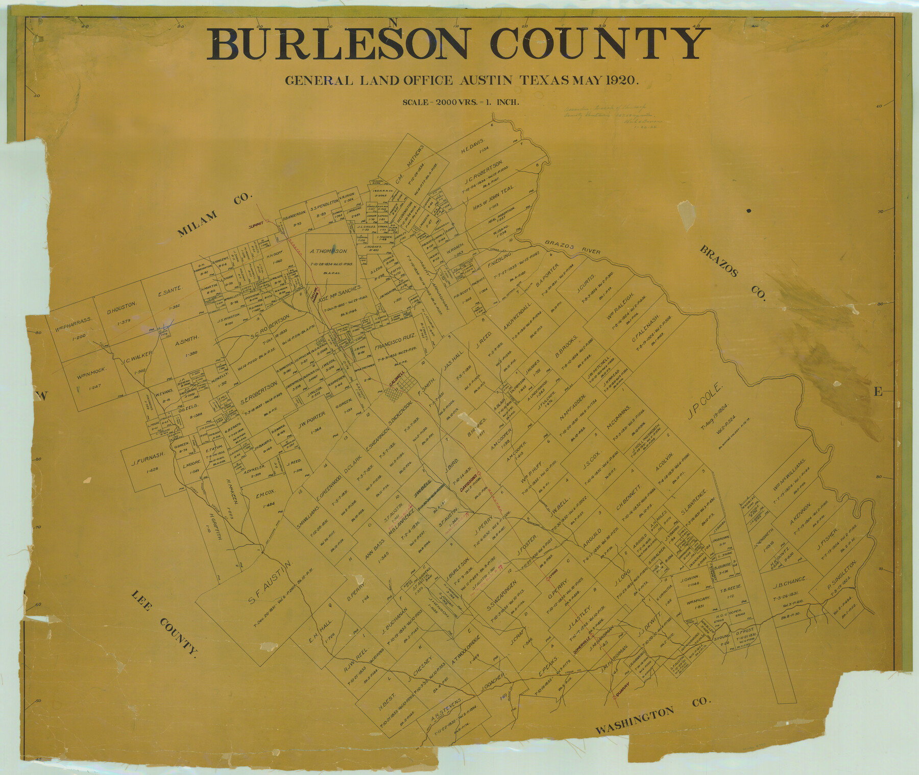
Burleson County
-
Map/Doc
4790
-
Collection
General Map Collection
-
Object Dates
1920 (Creation Date)
-
People and Organizations
Texas General Land Office (Publisher)
-
Counties
Burleson
-
Subjects
County
-
Height x Width
38.0 x 45.0 inches
96.5 x 114.3 cm
-
Comments
Draftsman was probably Tom Atlee.
Partially adopted and conservation funded in 2005 by Julie Fuller in honor of George Pazdral and Friends of the Texas General Land Office. -
Features
Davidsons
Burns Creek
Neills Creek
Yegua Creek
Somerville
Birch Creek
Lyons
Crooked Creek
First Yegua Creek
Sulphur Branch of First Yegua Creek
Summit
Caldwell
Davidsons Creek
Yellow Prairie
New S[an] A[ntonio] Road
San Antonio Road
Brazos River
Cedar Creek
GC&SF
Part of: General Map Collection

Childress County Working Sketch 6

Print $20.00
- Digital $50.00
Childress County Working Sketch 6
1954
Size 19.1 x 24.3 inches
Map/Doc 68022
Gonzales County Rolled Sketch 1

Print $20.00
- Digital $50.00
Gonzales County Rolled Sketch 1
1917
Size 21.9 x 23.9 inches
Map/Doc 6027
Kerr County Working Sketch 11

Print $20.00
- Digital $50.00
Kerr County Working Sketch 11
1951
Size 30.3 x 29.9 inches
Map/Doc 70042
Terrell County Working Sketch 79

Print $40.00
- Digital $50.00
Terrell County Working Sketch 79
1983
Size 43.0 x 55.8 inches
Map/Doc 69600
Flight Mission No. CUG-3P, Frame 78, Kleberg County

Print $20.00
- Digital $50.00
Flight Mission No. CUG-3P, Frame 78, Kleberg County
1956
Size 18.5 x 22.2 inches
Map/Doc 86253
Marion County Sketch File 2

Print $4.00
- Digital $50.00
Marion County Sketch File 2
1853
Size 8.3 x 14.2 inches
Map/Doc 30564
[Surveys along the Polk and Tyler County border]
![333, [Surveys along the Polk and Tyler County border], General Map Collection](https://historictexasmaps.com/wmedia_w700/maps/333.tif.jpg)
Print $2.00
- Digital $50.00
[Surveys along the Polk and Tyler County border]
Size 9.3 x 6.0 inches
Map/Doc 333
La Salle County Working Sketch 31

Print $20.00
- Digital $50.00
La Salle County Working Sketch 31
1955
Size 25.0 x 27.8 inches
Map/Doc 70332
Colorado River, Glen Flora Sheet

Print $6.00
- Digital $50.00
Colorado River, Glen Flora Sheet
1941
Size 24.5 x 32.6 inches
Map/Doc 65310
Comanche County Sketch File 22

Print $4.00
- Digital $50.00
Comanche County Sketch File 22
1873
Size 15.2 x 9.2 inches
Map/Doc 19106
Nueces County Working Sketch 4

Print $20.00
- Digital $50.00
Nueces County Working Sketch 4
1951
Size 46.8 x 36.2 inches
Map/Doc 71306
You may also like
The United States and the Relative Position of the Oregon and Texas

Print $20.00
- Digital $50.00
The United States and the Relative Position of the Oregon and Texas
1850
Size 16.8 x 23.1 inches
Map/Doc 93666
Sterling County Sketch File 2

Print $6.00
- Digital $50.00
Sterling County Sketch File 2
Size 10.7 x 15.6 inches
Map/Doc 37113
Val Verde County Working Sketch 12

Print $20.00
- Digital $50.00
Val Verde County Working Sketch 12
1920
Size 29.0 x 24.3 inches
Map/Doc 72147
Montgomery County Rolled Sketch 46

Print $20.00
- Digital $50.00
Montgomery County Rolled Sketch 46
2006
Size 28.2 x 23.0 inches
Map/Doc 87940
Gulf Intracoastal Waterway - Aransas Bay to Corpus Christi Bay - Modified Route Main Channel

Print $20.00
- Digital $50.00
Gulf Intracoastal Waterway - Aransas Bay to Corpus Christi Bay - Modified Route Main Channel
1960
Size 31.0 x 42.7 inches
Map/Doc 61901
Galveston County Rolled Sketch 34C

Print $20.00
- Digital $50.00
Galveston County Rolled Sketch 34C
1978
Size 29.0 x 40.8 inches
Map/Doc 5969
Flight Mission No. DIX-7P, Frame 90, Aransas County

Print $20.00
- Digital $50.00
Flight Mission No. DIX-7P, Frame 90, Aransas County
1956
Size 18.8 x 22.4 inches
Map/Doc 83884
Map of a resurvey of the land involved in the suit of Lillian-Vineyard vs. O.M. O'Connor et al (Lamar townlots excepted)

Print $20.00
- Digital $50.00
Map of a resurvey of the land involved in the suit of Lillian-Vineyard vs. O.M. O'Connor et al (Lamar townlots excepted)
1911
Size 18.8 x 17.9 inches
Map/Doc 481
Rusk County Rolled Sketch 13

Print $20.00
- Digital $50.00
Rusk County Rolled Sketch 13
Size 30.1 x 26.4 inches
Map/Doc 7548
Wise County Rolled Sketch 3

Print $20.00
- Digital $50.00
Wise County Rolled Sketch 3
Size 36.4 x 45.0 inches
Map/Doc 10156
[Pencil sketch of C. B., H. L. and Jno. Robertson and surrounding surveys]
![89981, [Pencil sketch of C. B., H. L. and Jno. Robertson and surrounding surveys], Twichell Survey Records](https://historictexasmaps.com/wmedia_w700/maps/89981-1.tif.jpg)
Print $20.00
- Digital $50.00
[Pencil sketch of C. B., H. L. and Jno. Robertson and surrounding surveys]
Size 21.1 x 9.8 inches
Map/Doc 89981
United States - Gulf Coast - Padre I. and Laguna Madre Lat. 27° 12' to Lat. 26° 33' Texas

Print $20.00
- Digital $50.00
United States - Gulf Coast - Padre I. and Laguna Madre Lat. 27° 12' to Lat. 26° 33' Texas
1913
Size 26.9 x 18.2 inches
Map/Doc 72820