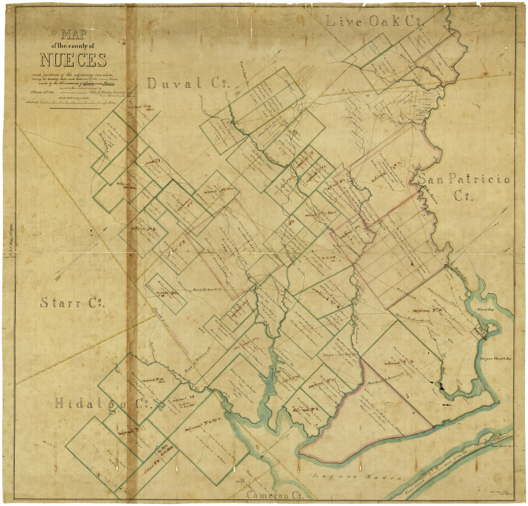
Map of the County of Nueces and portions of adjoining counties showing the locality, dates and claimants of the several grants made by the government of Spain and Mexico
-
Map/Doc
4677
-
Collection
General Map Collection
-
Object Dates
11/20/1859 (Creation Date)
2/1/1860 (File Date)
-
People and Organizations
Nueces District (Publisher)
Felix A. Blucher (Surveyor/Engineer)
Felix A. Blucher (Compiler)
Felix A. Blucher (Draftsman)
-
Counties
Nueces San Patricio Kleberg Kenedy Jim Wells
-
Subjects
County
-
Height x Width
37.3 x 39.0 inches
94.7 x 99.1 cm
-
Comments
Conservation funded in 2001 with donation from Frost Bank.
-
Features
Worthington [Rancho]
S[an]ta Rosa
Rancho del Tule
Los Olmos Creek
El Grullo [Lake]
Rancho India Puerta
Brownsville
Oso Creek
Corpus Christi Bay
Corpus Christi
Oso
Britten [Rancho]
Mustang Island
Santa Petronila Creek
Escondido Creek
Jaboncillas Creek
Road to Rio Grande City
Rancho Escondida
Rancho de Sa[nta] Getrudis
Tranquitas Creek
C. Balero [Rancho]
Blucher's Rancho
Clark's Rancho
Padre Island
Los Pajaros
Mail Route to Brownsville
Rancho W. W. Chapman
E. Mann [Rancho]
Casablanca
Road to Eagle Pass
Cloa
Dix
Valeña
Laguna Madre
Road to Laredo
Tulosa
Salto Mountain
Paisano Creek
Road to Brownsville
Banquete
Lagarto Creek
Road to Banquetes [sic] and San Diego
San Diego Road
Encinal
Corpus Christi Pass
Casablanca [Rancho]
Baskins R[ancho]
Walworth's Rancho
Agua Dulce Creek
Rancho de los Presenos
Sloss [Rancho]
J. Vales Rancho
Anacuas Creek
San Diego Creek
Agua Paquita Creek
J. Vates Rancho
Dwyer [Rancho]
E. Mann [Rancho]
Beldon
A. Perez Rancho
Macklenburgers Rancho
Casa Ramirenño
Vilena Mountain
Fort Merrill
Ramireño Creek
Chiltipin Creek
Road to Eagle Pass
Puentecilas Creek
Banquetes Road
Nueces Bay
Nueces River
Nuecestown
W. Rogers [Rancho]
McEvers [Ranch]
Morris Rancho
Carrita Creek
San Fernando Creek
Merily's Rancho
Carancahuas Creek
Barranco Blanco [Rancho]
Durst's Rancho
Dennis O'Farrell Ranch
Rancho Trinidad
Pintas Creek
J. Basse's Rancho
O'Reilly [Rancho]
S[anta] Margarita
San Patricio
J. Mann [Rancho]
Part of: General Map Collection
Hudspeth County Sketch File 10a

Print $4.00
- Digital $50.00
Hudspeth County Sketch File 10a
1902
Size 11.2 x 8.8 inches
Map/Doc 26901
Colorado County Sketch File 15

Print $4.00
- Digital $50.00
Colorado County Sketch File 15
Size 13.0 x 8.1 inches
Map/Doc 18943
Real County Rolled Sketch 18

Print $20.00
- Digital $50.00
Real County Rolled Sketch 18
Size 22.0 x 28.0 inches
Map/Doc 7464
Garza County Rolled Sketch 5A

Print $40.00
- Digital $50.00
Garza County Rolled Sketch 5A
Size 36.4 x 53.8 inches
Map/Doc 3830
Harrison County

Print $20.00
- Digital $50.00
Harrison County
1857
Size 20.3 x 21.0 inches
Map/Doc 1116
Map from Corpus Christi to Matagorda Bays, Texas [Inset: Survey of the channel of Copono Bay]
![72973, Map from Corpus Christi to Matagorda Bays, Texas [Inset: Survey of the channel of Copono Bay], General Map Collection](https://historictexasmaps.com/wmedia_w700/maps/72973.tif.jpg)
Print $20.00
- Digital $50.00
Map from Corpus Christi to Matagorda Bays, Texas [Inset: Survey of the channel of Copono Bay]
1846
Size 18.2 x 27.5 inches
Map/Doc 72973

[T. & G. Ry. Main Line, Texas, Right of Way Map, Center to Gary]
![64572, [T. & G. Ry. Main Line, Texas, Right of Way Map, Center to Gary], General Map Collection](https://historictexasmaps.com/wmedia_w700/maps/64572-1.tif.jpg)
Print $40.00
- Digital $50.00
[T. & G. Ry. Main Line, Texas, Right of Way Map, Center to Gary]
1917
Size 31.9 x 104.6 inches
Map/Doc 64572
Dawson County Working Sketch Graphic Index

Print $20.00
- Digital $50.00
Dawson County Working Sketch Graphic Index
1959
Size 40.7 x 33.4 inches
Map/Doc 76518
Map and Profile No. 1 from the Red River to the Rio Grande; from Explorations and surveys made under the direction of the Hon. Jeffeson Davis, Secretary of War

Print $40.00
- Digital $50.00
Map and Profile No. 1 from the Red River to the Rio Grande; from Explorations and surveys made under the direction of the Hon. Jeffeson Davis, Secretary of War
1856
Size 30.5 x 57.0 inches
Map/Doc 4330
San Augustine County Sketch File 19

Print $23.00
San Augustine County Sketch File 19
Size 14.8 x 14.2 inches
Map/Doc 35678
Denton County Working Sketch 17

Print $20.00
- Digital $50.00
Denton County Working Sketch 17
1973
Size 31.6 x 33.6 inches
Map/Doc 68622
You may also like
Northwest Part Pecos County

Print $20.00
- Digital $50.00
Northwest Part Pecos County
1975
Size 42.2 x 42.2 inches
Map/Doc 77395

Flight Mission No. BQR-4K, Frame 65, Brazoria County

Print $20.00
- Digital $50.00
Flight Mission No. BQR-4K, Frame 65, Brazoria County
1952
Size 18.5 x 22.3 inches
Map/Doc 83998
Edwards County Sketch File 35a

Print $20.00
- Digital $50.00
Edwards County Sketch File 35a
1928
Size 33.0 x 23.5 inches
Map/Doc 11435
Johnson County Sketch File 22

Print $20.00
- Digital $50.00
Johnson County Sketch File 22
1873
Size 18.8 x 16.2 inches
Map/Doc 11891
Flight Mission No. CLL-3N, Frame 12, Willacy County

Print $20.00
- Digital $50.00
Flight Mission No. CLL-3N, Frame 12, Willacy County
1954
Size 18.4 x 22.0 inches
Map/Doc 87078
Flight Mission No. CRC-3R, Frame 42, Chambers County

Print $20.00
- Digital $50.00
Flight Mission No. CRC-3R, Frame 42, Chambers County
1956
Size 18.8 x 22.4 inches
Map/Doc 84815
Houston County Working Sketch 35

Print $20.00
- Digital $50.00
Houston County Working Sketch 35
1999
Size 27.8 x 29.0 inches
Map/Doc 66265
San Patricio County Aerial Photograph Index Sheet 3

Print $20.00
- Digital $50.00
San Patricio County Aerial Photograph Index Sheet 3
1957
Size 19.1 x 24.0 inches
Map/Doc 83745
Rio Grande Rectification Project, El Paso and Juarez Valley

Print $20.00
- Digital $50.00
Rio Grande Rectification Project, El Paso and Juarez Valley
1935
Size 10.9 x 29.6 inches
Map/Doc 60868
South Part Pecos County

Print $20.00
- Digital $50.00
South Part Pecos County
1976
Size 35.0 x 42.9 inches
Map/Doc 77393
Dawson County Working Sketch 21

Print $20.00
- Digital $50.00
Dawson County Working Sketch 21
1963
Size 24.0 x 24.0 inches
Map/Doc 68565