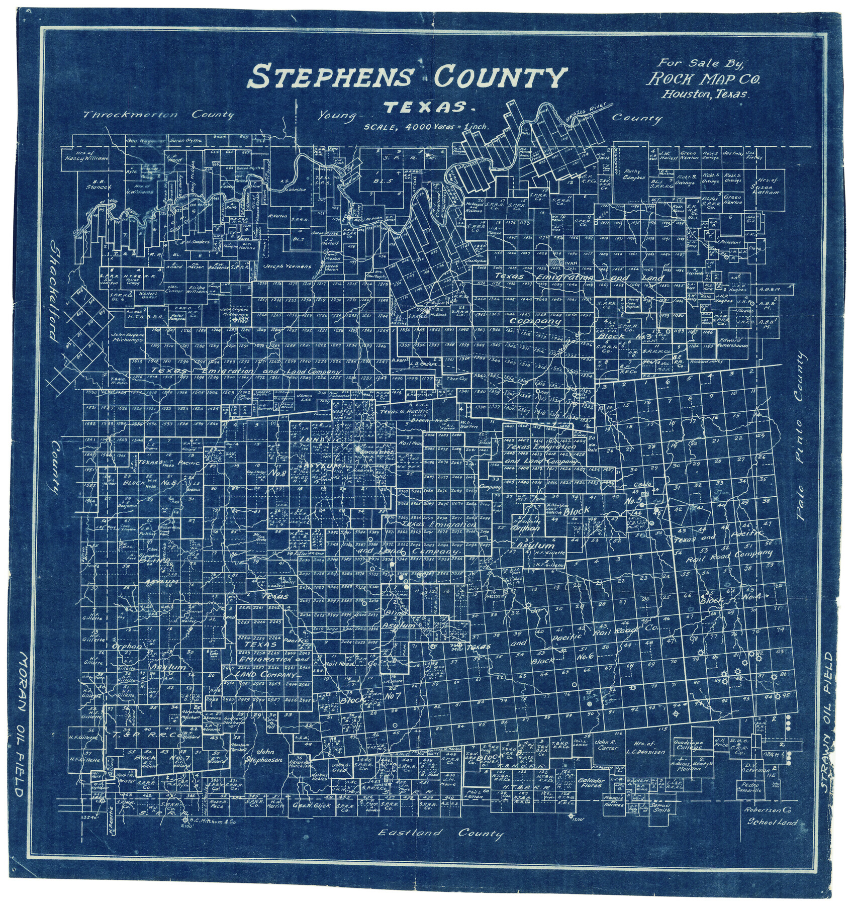
Stephens County Texas
Stephens County Sketch File 18
-
Map/Doc
4627
-
Collection
General Map Collection
-
Object Dates
4/4/1918 (File Date)
-
People and Organizations
Rock Map Company, Houston (Publisher)
-
Counties
Stephens
-
Subjects
County
-
Height x Width
20.8 x 18.6 inches
52.8 x 47.2 cm
-
Comments
Mailed originally to the Hon. J. T. Robinson of Austin, Texas by the Rock Map Company of Houston>
Received in the land office in 1918.
Part of: General Map Collection
Matagorda County Sketch File 25

Print $20.00
- Digital $50.00
Matagorda County Sketch File 25
1903
Size 18.1 x 30.3 inches
Map/Doc 12041
Galveston County NRC Article 33.136 Sketch 58

Print $26.00
- Digital $50.00
Galveston County NRC Article 33.136 Sketch 58
2009
Size 12.0 x 17.6 inches
Map/Doc 94592
Sutton County Working Sketch 56

Print $20.00
- Digital $50.00
Sutton County Working Sketch 56
1958
Size 27.6 x 28.8 inches
Map/Doc 62399
Upton County Sketch File 21

Print $20.00
- Digital $50.00
Upton County Sketch File 21
1927
Size 15.0 x 23.7 inches
Map/Doc 12518

Hutchinson County Sketch File 45

Print $22.00
- Digital $50.00
Hutchinson County Sketch File 45
1991
Size 11.1 x 8.8 inches
Map/Doc 27354
Calhoun County Sketch File 10

Print $11.00
- Digital $50.00
Calhoun County Sketch File 10
1956
Size 14.3 x 8.8 inches
Map/Doc 35940
San Patricio County Rolled Sketch 27

Print $40.00
- Digital $50.00
San Patricio County Rolled Sketch 27
Size 49.5 x 37.8 inches
Map/Doc 9890
Bee County Working Sketch 33

Print $20.00
- Digital $50.00
Bee County Working Sketch 33
1980
Size 32.0 x 28.2 inches
Map/Doc 67284
Comal County Rolled Sketch 3

Print $20.00
- Digital $50.00
Comal County Rolled Sketch 3
1977
Size 19.0 x 17.3 inches
Map/Doc 5538
Kleberg County Rolled Sketch 10-21

Print $20.00
- Digital $50.00
Kleberg County Rolled Sketch 10-21
1952
Size 37.5 x 32.9 inches
Map/Doc 9403
Williamson County Sketch File 18

Print $6.00
- Digital $50.00
Williamson County Sketch File 18
1871
Size 12.8 x 8.1 inches
Map/Doc 40342
You may also like
Flight Mission No. DQN-5K, Frame 141, Calhoun County

Print $20.00
- Digital $50.00
Flight Mission No. DQN-5K, Frame 141, Calhoun County
1953
Size 18.7 x 21.9 inches
Map/Doc 84416
Brazoria County Rolled Sketch 35

Print $40.00
- Digital $50.00
Brazoria County Rolled Sketch 35
1934
Size 32.7 x 60.0 inches
Map/Doc 8459
America's Fun-Tier: Texas 1965 Official Highway Travel Map

Digital $50.00
America's Fun-Tier: Texas 1965 Official Highway Travel Map
Size 28.2 x 36.4 inches
Map/Doc 94325
Angelina County Sketch File 11f

Print $4.00
- Digital $50.00
Angelina County Sketch File 11f
1885
Size 8.2 x 12.6 inches
Map/Doc 12954
Polk County Working Sketch 39

Print $40.00
- Digital $50.00
Polk County Working Sketch 39
1978
Size 43.7 x 65.6 inches
Map/Doc 71656
United States

Print $40.00
- Digital $50.00
United States
1961
Size 55.0 x 81.2 inches
Map/Doc 75922
Aransas County Rolled Sketch 19

Print $20.00
- Digital $50.00
Aransas County Rolled Sketch 19
1979
Size 24.8 x 36.7 inches
Map/Doc 82559
Terry County Sketch File 19

Print $6.00
- Digital $50.00
Terry County Sketch File 19
1998
Size 11.2 x 8.9 inches
Map/Doc 38047
Map of Jefferson County

Print $20.00
- Digital $50.00
Map of Jefferson County
1862
Size 22.5 x 21.9 inches
Map/Doc 3727
Aransas County Rolled Sketch 2

Print $40.00
- Digital $50.00
Aransas County Rolled Sketch 2
Size 42.9 x 48.2 inches
Map/Doc 73614
Castro County

Print $20.00
- Digital $50.00
Castro County
1932
Size 43.4 x 38.6 inches
Map/Doc 73102
[Leagues 212- 217, 241- 244, and Vicinity]
![91430, [Leagues 212- 217, 241- 244, and Vicinity], Twichell Survey Records](https://historictexasmaps.com/wmedia_w700/maps/91430-1.tif.jpg)
Print $20.00
- Digital $50.00
[Leagues 212- 217, 241- 244, and Vicinity]
1902
Size 20.6 x 6.4 inches
Map/Doc 91430