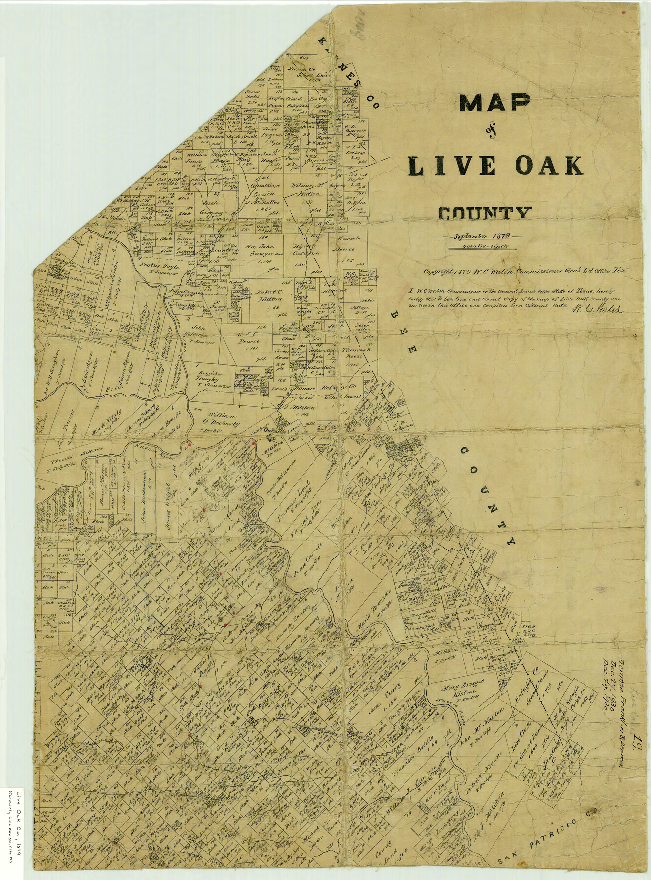
Live Oak County Sketch File 19
[Map of Live Oak County]
-
Map/Doc
4580
-
Collection
General Map Collection
-
Object Dates
9/1879 (Creation Date)
1879 (Copyright Date)
-
People and Organizations
W.C. Walsh (GLO Commissioner)
-
Counties
Live Oak Karnes Bee San Patricio
-
Subjects
County Surveying Sketch File
-
Height x Width
24.7 x 18.3 inches
62.7 x 46.5 cm
-
Medium
paper, manuscript
-
Scale
1:4000
-
Comments
See Live Oak County Sketch File 19 (30289) for associated letter.
-
Features
San Christoval Creek
Atascosa Creek
Rio Frio
Puenta de la Piedra
Oakville
Nueces River
Spring Creek
Long Hollow
Olmos Creek
Carrease Creek
Arroyo Legurdo
Related maps
Live Oak County Sketch File 19

Print $22.00
- Digital $50.00
Live Oak County Sketch File 19
1930
Size 11.2 x 8.6 inches
Map/Doc 30289
Part of: General Map Collection
Angelina County

Print $40.00
- Digital $50.00
Angelina County
1945
Size 40.2 x 49.7 inches
Map/Doc 95417
Goliad County Sketch File 3

Print $4.00
- Digital $50.00
Goliad County Sketch File 3
1852
Size 12.4 x 8.2 inches
Map/Doc 24214
Flight Mission No. DQN-1K, Frame 73, Calhoun County

Print $20.00
- Digital $50.00
Flight Mission No. DQN-1K, Frame 73, Calhoun County
1953
Size 18.5 x 22.2 inches
Map/Doc 84160
Roseborough Lake Sheet, Bowie County, Red River

Print $20.00
- Digital $50.00
Roseborough Lake Sheet, Bowie County, Red River
1934
Size 39.5 x 23.0 inches
Map/Doc 75273
Harlem State Farm, East Tract

Print $3.00
- Digital $50.00
Harlem State Farm, East Tract
Size 15.6 x 11.9 inches
Map/Doc 62983
Martin County Sketch File 14

Print $46.00
- Digital $50.00
Martin County Sketch File 14
1937
Size 11.2 x 8.8 inches
Map/Doc 30671
Supreme Court of the United States, October Term, 1923, No. 15, Original - The State of Oklahoma, Complainant vs. The State of Texas, Defendant, The United States, Intervener; Report of Medial Line Survey

Print $28.00
- Digital $50.00
Supreme Court of the United States, October Term, 1923, No. 15, Original - The State of Oklahoma, Complainant vs. The State of Texas, Defendant, The United States, Intervener; Report of Medial Line Survey
1924
Size 5.9 x 9.1 inches
Map/Doc 3055
Flight Mission No. BRA-8M, Frame 118, Jefferson County

Print $20.00
- Digital $50.00
Flight Mission No. BRA-8M, Frame 118, Jefferson County
1953
Size 18.6 x 22.3 inches
Map/Doc 85614
Milam County Sketch File 6

Print $4.00
- Digital $50.00
Milam County Sketch File 6
1902
Size 14.2 x 8.6 inches
Map/Doc 31634
[Surveys near Hondo Creek]
![226, [Surveys near Hondo Creek], General Map Collection](https://historictexasmaps.com/wmedia_w700/maps/226.tif.jpg)
Print $2.00
- Digital $50.00
[Surveys near Hondo Creek]
1847
Size 13.8 x 8.0 inches
Map/Doc 226
Maverick County Sketch File 23a

Print $20.00
- Digital $50.00
Maverick County Sketch File 23a
Size 41.0 x 41.1 inches
Map/Doc 10537
Clay County Sketch File 32

Print $22.00
- Digital $50.00
Clay County Sketch File 32
Size 8.6 x 7.8 inches
Map/Doc 18458
You may also like
Map Showing Soash Lands in Castro, Lamb, and Hale Counties, Texas

Print $20.00
- Digital $50.00
Map Showing Soash Lands in Castro, Lamb, and Hale Counties, Texas
1907
Size 13.9 x 17.6 inches
Map/Doc 91000
Nueces County Rolled Sketch 28

Print $20.00
- Digital $50.00
Nueces County Rolled Sketch 28
Size 16.8 x 25.1 inches
Map/Doc 6874
Outer Continental Shelf Leasing Maps (Texas Offshore Operations)

Print $20.00
- Digital $50.00
Outer Continental Shelf Leasing Maps (Texas Offshore Operations)
1954
Size 20.3 x 15.5 inches
Map/Doc 75839
Dawson County Rolled Sketch 9

Print $20.00
- Digital $50.00
Dawson County Rolled Sketch 9
1953
Size 36.6 x 45.7 inches
Map/Doc 8773
Crockett County Working Sketch 73

Print $20.00
- Digital $50.00
Crockett County Working Sketch 73
1963
Size 38.8 x 33.8 inches
Map/Doc 68406

Val Verde County Rolled Sketch 43

Print $20.00
- Digital $50.00
Val Verde County Rolled Sketch 43
1920
Size 20.4 x 22.6 inches
Map/Doc 8117
La Salle County Rolled Sketch 27

Print $20.00
- Digital $50.00
La Salle County Rolled Sketch 27
1979
Size 29.0 x 38.2 inches
Map/Doc 6588
![91861, [Block D7], Twichell Survey Records](https://historictexasmaps.com/wmedia_w700/maps/91861-1.tif.jpg)

Presidio County Rolled Sketch 2

Print $20.00
- Digital $50.00
Presidio County Rolled Sketch 2
Size 30.2 x 18.6 inches
Map/Doc 7326
