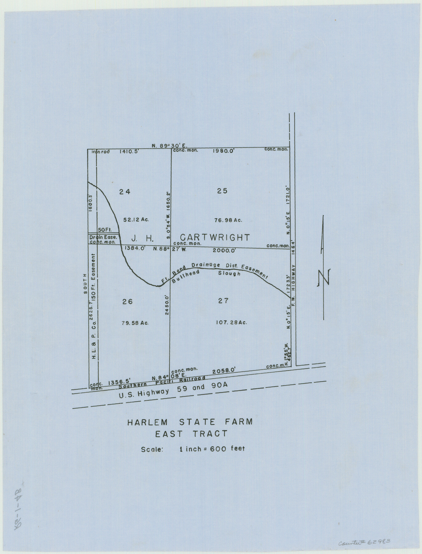
Harlem State Farm, East Tract
RG-1-4b
-
Map/Doc
62983
-
Collection
General Map Collection
-
Counties
Fort Bend
-
Height x Width
15.6 x 11.9 inches
39.6 x 30.2 cm
Part of: General Map Collection
Amistad International Reservoir on Rio Grande 92

Print $20.00
- Digital $50.00
Amistad International Reservoir on Rio Grande 92
1950
Size 28.5 x 40.6 inches
Map/Doc 75522
Ward County Sketch File 7

Print $4.00
- Digital $50.00
Ward County Sketch File 7
1927
Size 9.8 x 8.6 inches
Map/Doc 39621
Presidio County Working Sketch 12a

Print $20.00
- Digital $50.00
Presidio County Working Sketch 12a
1941
Size 23.7 x 43.1 inches
Map/Doc 71688
Lamb County Boundary File 4

Print $16.00
- Digital $50.00
Lamb County Boundary File 4
Size 11.3 x 8.7 inches
Map/Doc 56084
Swisher County Working Sketch 6

Print $20.00
- Digital $50.00
Swisher County Working Sketch 6
1979
Size 23.2 x 19.7 inches
Map/Doc 62417
Flight Mission No. BRA-7M, Frame 76, Jefferson County

Print $20.00
- Digital $50.00
Flight Mission No. BRA-7M, Frame 76, Jefferson County
1953
Size 18.8 x 22.3 inches
Map/Doc 85498
Southern Part of Laguna Madre

Print $20.00
- Digital $50.00
Southern Part of Laguna Madre
1952
Size 44.7 x 35.2 inches
Map/Doc 73537
Motley County Sketch File 5 (N)

Print $8.00
- Digital $50.00
Motley County Sketch File 5 (N)
Size 12.6 x 8.3 inches
Map/Doc 32000
Donley County Boundary File 5

Print $4.00
- Digital $50.00
Donley County Boundary File 5
Size 11.2 x 8.8 inches
Map/Doc 52635
Map of Hays Co.

Print $20.00
- Digital $50.00
Map of Hays Co.
1902
Size 46.5 x 40.7 inches
Map/Doc 4679
Real County Sketch File 17

Print $6.00
- Digital $50.00
Real County Sketch File 17
1942
Size 5.6 x 4.3 inches
Map/Doc 35073
Flight Mission No. CUI-1H, Frame 168, Milam County

Print $20.00
- Digital $50.00
Flight Mission No. CUI-1H, Frame 168, Milam County
1951
Size 18.4 x 22.3 inches
Map/Doc 86610
You may also like
Hudspeth County Sketch File 10a

Print $4.00
- Digital $50.00
Hudspeth County Sketch File 10a
1902
Size 11.2 x 8.8 inches
Map/Doc 26901
Starr County Working Sketch 8

Print $20.00
- Digital $50.00
Starr County Working Sketch 8
1939
Size 21.9 x 28.8 inches
Map/Doc 63924
[John H. Gibson Section 892 and Surrounding Surveys]
![92841, [John H. Gibson Section 892 and Surrounding Surveys], Twichell Survey Records](https://historictexasmaps.com/wmedia_w700/maps/92841-1.tif.jpg)
Print $3.00
- Digital $50.00
[John H. Gibson Section 892 and Surrounding Surveys]
Size 15.7 x 11.7 inches
Map/Doc 92841
Topography and Water Depth as Shown by the US Coast Survey of 1888

Print $20.00
- Digital $50.00
Topography and Water Depth as Shown by the US Coast Survey of 1888
1890
Size 16.9 x 18.9 inches
Map/Doc 5036
Henderson County Working Sketch 6

Print $20.00
- Digital $50.00
Henderson County Working Sketch 6
1919
Size 24.4 x 17.6 inches
Map/Doc 66139
Lubbock County Boundary File 8

Print $46.00
- Digital $50.00
Lubbock County Boundary File 8
Size 7.3 x 8.7 inches
Map/Doc 56525
United States - Gulf Coast Texas - Southern part of Laguna Madre

Print $20.00
- Digital $50.00
United States - Gulf Coast Texas - Southern part of Laguna Madre
1941
Size 26.5 x 18.4 inches
Map/Doc 72943
Montague County Working Sketch 7

Print $20.00
- Digital $50.00
Montague County Working Sketch 7
1927
Size 41.1 x 28.4 inches
Map/Doc 75970
Hale County Rolled Sketch 10

Print $40.00
- Digital $50.00
Hale County Rolled Sketch 10
Size 52.8 x 56.6 inches
Map/Doc 9096
The Mexican Department of Bexar. January 31, 1831

Print $20.00
The Mexican Department of Bexar. January 31, 1831
2020
Size 16.1 x 21.7 inches
Map/Doc 95968
Zapata County Working Sketch Graphic Index, Sheet 2 (Sketches 19 to Most Recent)

Print $40.00
- Digital $50.00
Zapata County Working Sketch Graphic Index, Sheet 2 (Sketches 19 to Most Recent)
1935
Size 55.6 x 41.5 inches
Map/Doc 76750
[Surveying Sketch of Martha G. Morrow, Mary Bigger, et al in Travis County]
![522, [Surveying Sketch of Martha G. Morrow, Mary Bigger, et al in Travis County], Maddox Collection](https://historictexasmaps.com/wmedia_w700/maps/522.tif.jpg)
Print $3.00
- Digital $50.00
[Surveying Sketch of Martha G. Morrow, Mary Bigger, et al in Travis County]
Size 12.4 x 9.6 inches
Map/Doc 522