Zavala County Sketch File 47
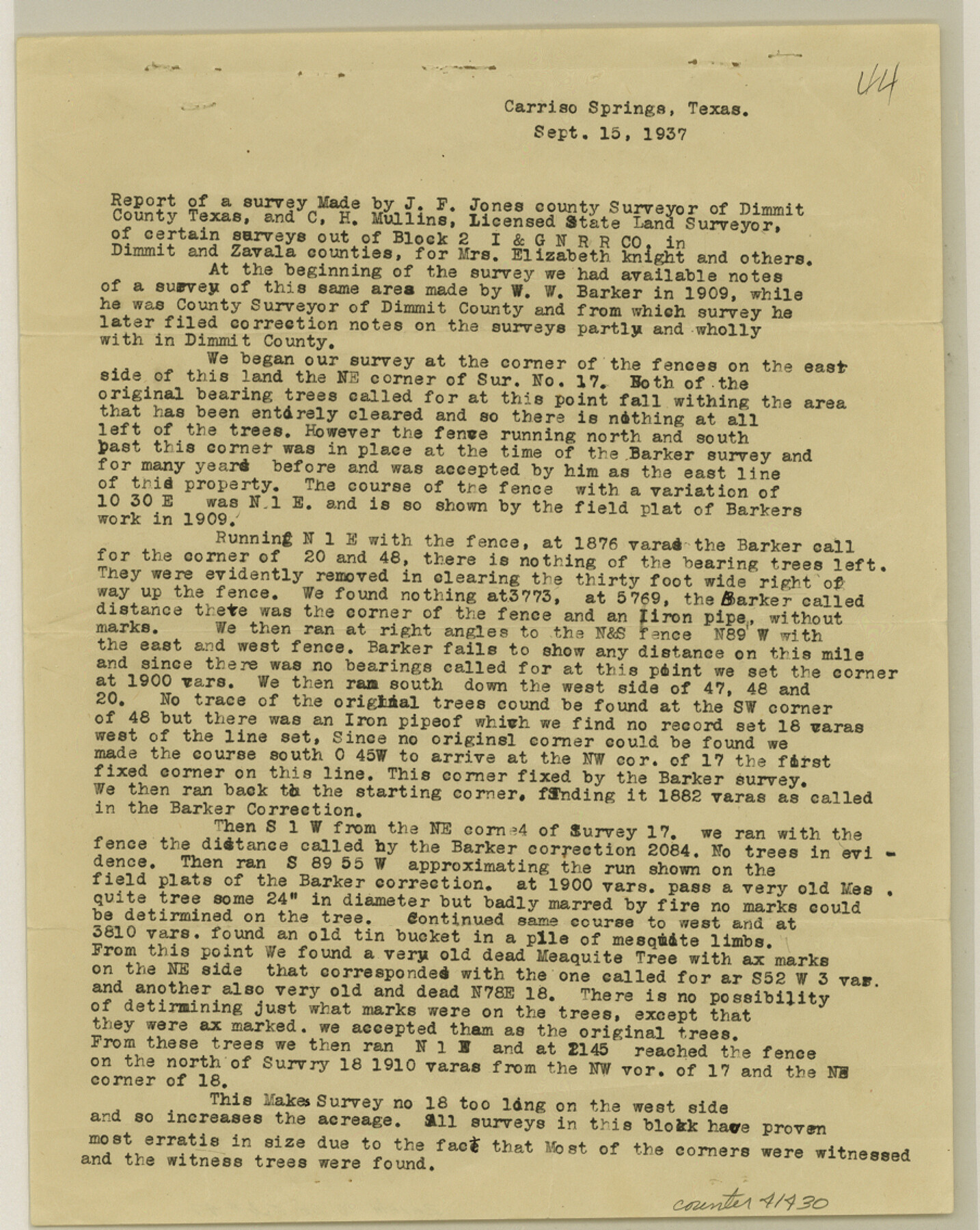
[Report of surveys in Block 2, I. & G. N. RR. Co.]
-
Map/Doc
41430
-
Collection
General Map Collection
-
Object Dates
9/15/1937 (Creation Date)
10/7/1937 (File Date)
-
People and Organizations
C.H. Mullins (Surveyor/Engineer)
J.F. Jones (Surveyor/Engineer)
-
Counties
Zavala Dimmit
-
Subjects
Surveying Sketch File
-
Height x Width
11.3 x 9.0 inches
28.7 x 22.9 cm
-
Medium
paper, print
Part of: General Map Collection
Matagorda County Sketch File 48

Print $108.00
- Digital $50.00
Matagorda County Sketch File 48
1998
Size 11.1 x 8.6 inches
Map/Doc 31009
Brazoria County NRC Article 33.136 Sketch 14

Print $36.00
- Digital $50.00
Brazoria County NRC Article 33.136 Sketch 14
2013
Size 24.0 x 36.0 inches
Map/Doc 95057
Gregg County Rolled Sketch 27

Print $137.00
- Digital $50.00
Gregg County Rolled Sketch 27
1933
Size 10.4 x 15.3 inches
Map/Doc 45625
Mills County Boundary File 4

Print $40.00
- Digital $50.00
Mills County Boundary File 4
Size 52.1 x 13.3 inches
Map/Doc 57293
Culberson County Rolled Sketch 29

Print $20.00
- Digital $50.00
Culberson County Rolled Sketch 29
Size 44.3 x 21.4 inches
Map/Doc 8745
Flight Mission No. DIX-5P, Frame 109, Aransas County

Print $20.00
- Digital $50.00
Flight Mission No. DIX-5P, Frame 109, Aransas County
1956
Size 17.8 x 18.1 inches
Map/Doc 83788
Highland Lakes 1981 in the scenic Hill Country of Central Texas

Digital $50.00
Highland Lakes 1981 in the scenic Hill Country of Central Texas
1981
Size 11.3 x 16.8 inches
Map/Doc 94174
Hood County Sketch File 25

Print $12.00
- Digital $50.00
Hood County Sketch File 25
1958
Size 11.3 x 8.9 inches
Map/Doc 26623
Jefferson County Rolled Sketch 35

Print $20.00
- Digital $50.00
Jefferson County Rolled Sketch 35
1957
Size 37.9 x 26.0 inches
Map/Doc 6394
Cottle County Working Sketch 17

Print $20.00
- Digital $50.00
Cottle County Working Sketch 17
1975
Size 32.5 x 34.1 inches
Map/Doc 68327
Culberson County Working Sketch 32

Print $20.00
- Digital $50.00
Culberson County Working Sketch 32
1958
Size 45.3 x 38.0 inches
Map/Doc 68485
Fractional Township No. 8 South Range No. 11 East of the Indian Meridian, Indian Territory

Print $20.00
- Digital $50.00
Fractional Township No. 8 South Range No. 11 East of the Indian Meridian, Indian Territory
1898
Size 19.2 x 24.3 inches
Map/Doc 75221
You may also like
Jefferson County NRC Article 33.136 Location Key Sheet

Print $20.00
- Digital $50.00
Jefferson County NRC Article 33.136 Location Key Sheet
1974
Size 27.0 x 23.0 inches
Map/Doc 77029
Map of Eastland County, the portion on the waters of Colorado River, Travis - the balance, Milam Land District

Print $20.00
- Digital $50.00
Map of Eastland County, the portion on the waters of Colorado River, Travis - the balance, Milam Land District
1860
Size 23.8 x 21.5 inches
Map/Doc 3501
Bowie County Sketch File 9

Print $10.00
- Digital $50.00
Bowie County Sketch File 9
Size 8.1 x 3.9 inches
Map/Doc 14907
The Republic County of Matagorda. Proposed, Late Fall 1837

Print $20.00
The Republic County of Matagorda. Proposed, Late Fall 1837
2020
Size 21.0 x 21.7 inches
Map/Doc 96214
Starr County Working Sketch 16

Print $20.00
- Digital $50.00
Starr County Working Sketch 16
1981
Size 21.5 x 12.0 inches
Map/Doc 63932
Jones County Sketch File 6

Print $2.00
- Digital $50.00
Jones County Sketch File 6
1873
Size 8.3 x 11.8 inches
Map/Doc 28494
Plat Showing Sections 11, 12, 19, and 20, Block A-9 Public School Land, Gaines County, Texas

Print $20.00
- Digital $50.00
Plat Showing Sections 11, 12, 19, and 20, Block A-9 Public School Land, Gaines County, Texas
1958
Size 18.2 x 21.8 inches
Map/Doc 92652
Flight Mission No. DIX-7P, Frame 92, Aransas County

Print $20.00
- Digital $50.00
Flight Mission No. DIX-7P, Frame 92, Aransas County
1956
Size 18.7 x 22.4 inches
Map/Doc 83886

[Copied from a chart of Galveston Bar and Harbor]
![72760, [Copied from a chart of Galveston Bar and Harbor], General Map Collection](https://historictexasmaps.com/wmedia_w700/maps/72760.tif.jpg)
Print $20.00
- Digital $50.00
[Copied from a chart of Galveston Bar and Harbor]
1846
Size 18.3 x 25.3 inches
Map/Doc 72760
Presidio County Sketch File 116

Print $86.00
- Digital $50.00
Presidio County Sketch File 116
1993
Size 11.4 x 8.7 inches
Map/Doc 34842
Pecos County Sketch File 104

Print $36.00
- Digital $50.00
Pecos County Sketch File 104
1966
Size 11.3 x 8.7 inches
Map/Doc 34020