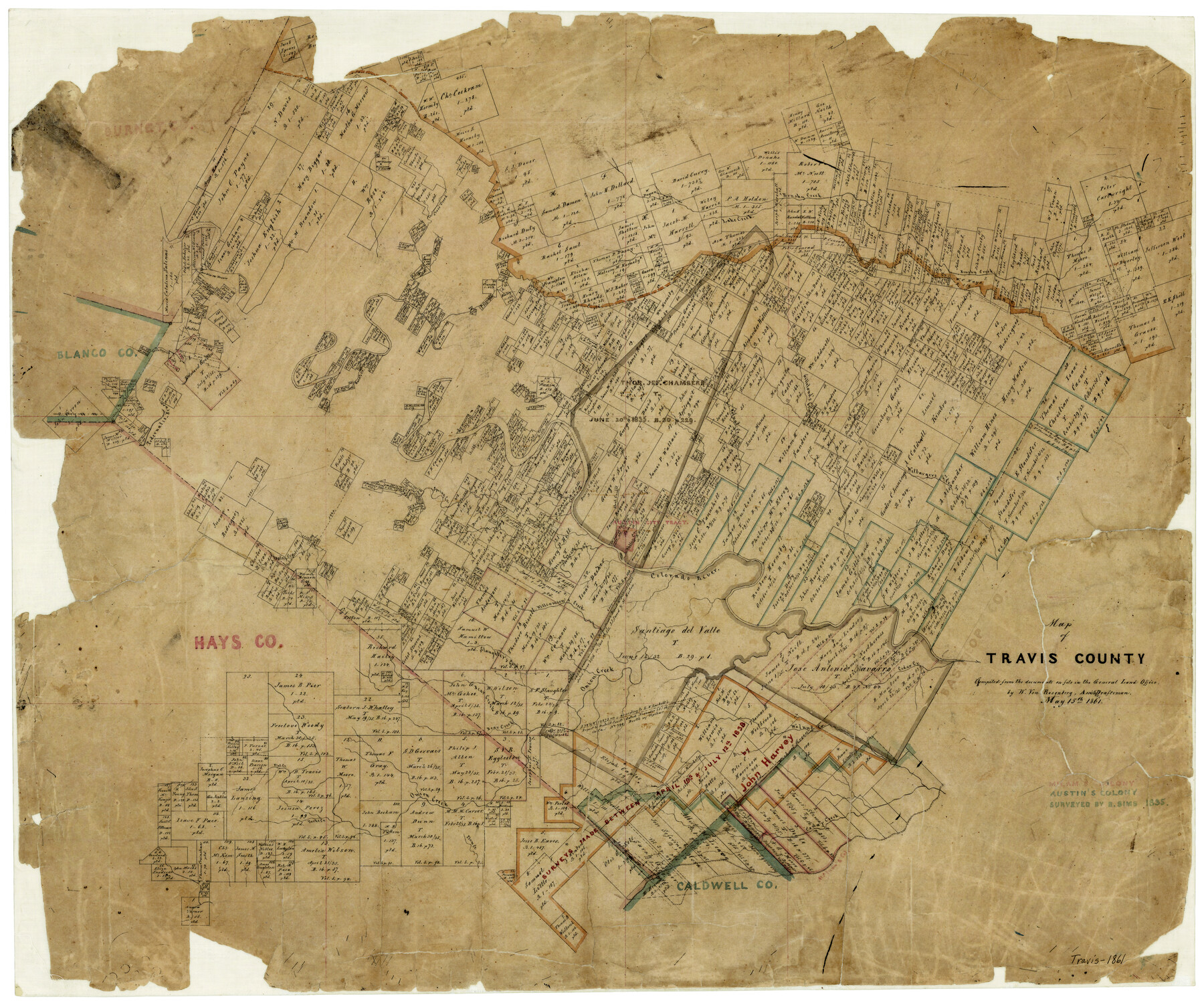
Map of Travis County
-
Map/Doc
4088
-
Collection
General Map Collection
-
Object Dates
5/15/1861 (Creation Date)
-
People and Organizations
W. von Rosenberg (Compiler)
-
Counties
Travis
-
Subjects
County
-
Height x Width
24.0 x 28.6 inches
61.0 x 72.6 cm
-
Features
Williamson's Creek
Hurst's Creek
Bull Creek
Cross Creek
Plum Creek
Flat Creek
Bear Creek
Slaughter's Creek
Onion Creek
Cedar Creek
Webber's Creek
Colorado River
Brushy Creek
Waller Creek
Austin
Wilbarger's Creek
Shoal Creek
Spring Creek
Pedernales River
Walnut Creek
Gilleland's Creek
Little Cypress Creek
Lake Creek
-
URLs
https://medium.com/save-texas-history/travis-county-1861-by-wilhelm-von-rosenberg-fef5b9fc015b#.czlyh26aa
Part of: General Map Collection
Map of Henderson Co.

Print $40.00
- Digital $50.00
Map of Henderson Co.
1886
Size 27.8 x 57.6 inches
Map/Doc 3663
Howard County Working Sketch 8

Print $20.00
- Digital $50.00
Howard County Working Sketch 8
1956
Size 25.3 x 31.3 inches
Map/Doc 66275
Old Miscellaneous File 11

Print $4.00
- Digital $50.00
Old Miscellaneous File 11
1886
Size 11.2 x 8.8 inches
Map/Doc 75437
Harris County Boundary File 40

Print $8.00
- Digital $50.00
Harris County Boundary File 40
Size 14.2 x 8.7 inches
Map/Doc 54370
Map of Hill County

Print $20.00
- Digital $50.00
Map of Hill County
1857
Size 21.5 x 25.6 inches
Map/Doc 3672
Real County Working Sketch 55

Print $20.00
- Digital $50.00
Real County Working Sketch 55
1960
Size 21.6 x 35.1 inches
Map/Doc 71947
McMullen County Sketch File 41

Print $20.00
- Digital $50.00
McMullen County Sketch File 41
1939
Size 20.6 x 17.1 inches
Map/Doc 12065
Martin County Sketch File 15

Print $4.00
- Digital $50.00
Martin County Sketch File 15
Size 11.9 x 8.3 inches
Map/Doc 30674
Roberts County Working Sketch 10

Print $20.00
- Digital $50.00
Roberts County Working Sketch 10
1965
Size 23.0 x 29.0 inches
Map/Doc 63536

Edwards County Rolled Sketch 16A

Print $20.00
- Digital $50.00
Edwards County Rolled Sketch 16A
1944
Size 25.0 x 19.0 inches
Map/Doc 5805
Crockett County Rolled Sketch 16

Print $20.00
- Digital $50.00
Crockett County Rolled Sketch 16
1880
Size 36.2 x 26.2 inches
Map/Doc 5581
You may also like
Duval County Working Sketch 40

Print $20.00
- Digital $50.00
Duval County Working Sketch 40
1960
Size 19.5 x 16.6 inches
Map/Doc 68764
Harris County Working Sketch 99

Print $20.00
- Digital $50.00
Harris County Working Sketch 99
1979
Size 46.6 x 30.1 inches
Map/Doc 65991
Sketch in Dawson County

Print $20.00
- Digital $50.00
Sketch in Dawson County
Size 18.7 x 12.4 inches
Map/Doc 92567
San Augustine County Sketch File 22

Print $4.00
San Augustine County Sketch File 22
Size 12.8 x 8.4 inches
Map/Doc 35687
Pecos County Sketch File 30

Print $20.00
- Digital $50.00
Pecos County Sketch File 30
Size 28.9 x 22.0 inches
Map/Doc 12172
Mills County Working Sketch 1

Print $20.00
- Digital $50.00
Mills County Working Sketch 1
Size 18.2 x 23.4 inches
Map/Doc 71031
Beaumont, Texas

Print $20.00
- Digital $50.00
Beaumont, Texas
1930
Size 10.3 x 32.7 inches
Map/Doc 96428
Schleicher County

Print $20.00
- Digital $50.00
Schleicher County
1940
Size 28.8 x 41.2 inches
Map/Doc 77418
Flight Mission No. CRE-2R, Frame 80, Jackson County

Print $20.00
- Digital $50.00
Flight Mission No. CRE-2R, Frame 80, Jackson County
1956
Size 18.7 x 22.3 inches
Map/Doc 85352
La Salle County Sketch File 8

Print $20.00
- Digital $50.00
La Salle County Sketch File 8
Size 27.2 x 19.3 inches
Map/Doc 11979
Sutton County Sketch File 42

Print $6.00
- Digital $50.00
Sutton County Sketch File 42
1940
Size 11.2 x 8.8 inches
Map/Doc 37509
Special Map of the Great Southwest for Burke's Texas Almanac

Print $20.00
Special Map of the Great Southwest for Burke's Texas Almanac
1885
Size 42.1 x 28.5 inches
Map/Doc 76214