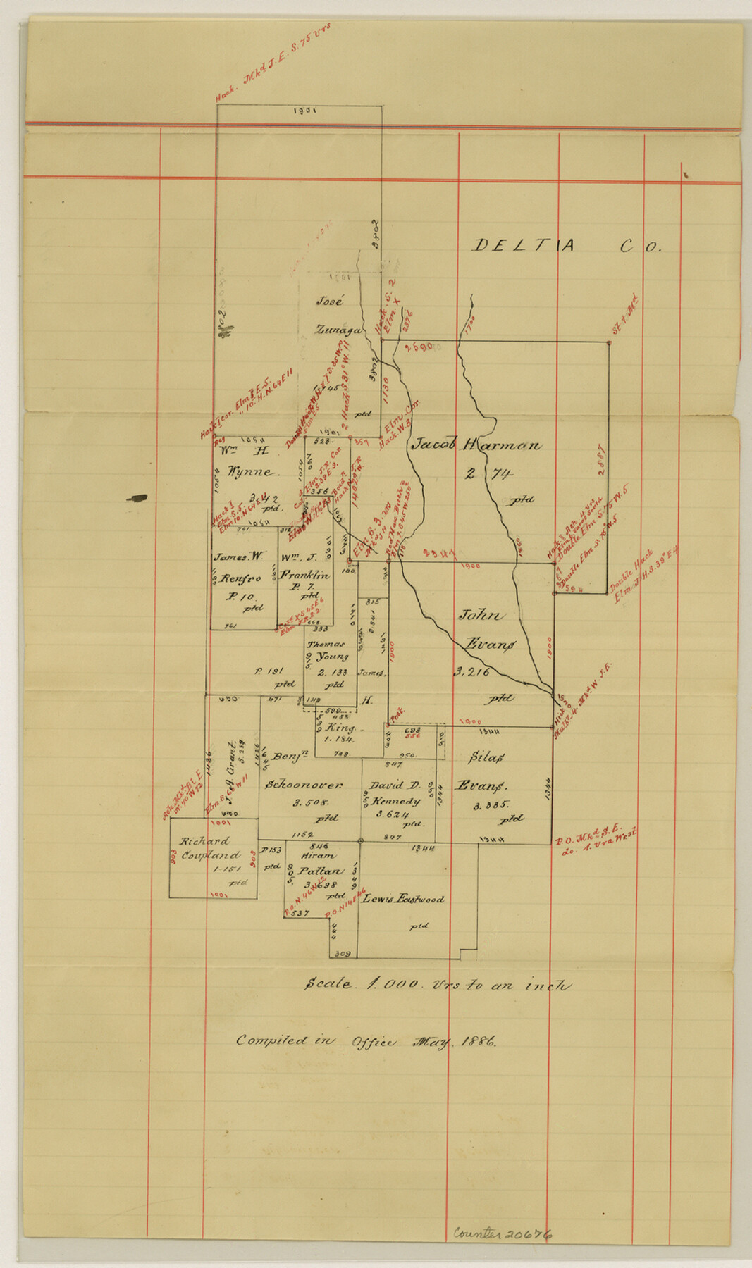
Delta County Sketch File 5
[Sketch northeast of Cooper]
-
Map/Doc
20676
-
Collection
General Map Collection
-
Object Dates
1886 (Creation Date)
-
People and Organizations
Pressler (Surveyor/Engineer)
-
Counties
Delta
-
Subjects
Surveying Sketch File
-
Height x Width
14.6 x 8.6 inches
37.1 x 21.8 cm
-
Medium
paper, manuscript
-
Scale
1:1000
Part of: General Map Collection
Marion County Working Sketch 27

Print $20.00
- Digital $50.00
Marion County Working Sketch 27
1971
Size 44.8 x 41.0 inches
Map/Doc 70803
Martin County Rolled Sketch 6

Print $20.00
- Digital $50.00
Martin County Rolled Sketch 6
Size 25.8 x 26.9 inches
Map/Doc 6666
Floyd County Sketch File 20

Print $4.00
- Digital $50.00
Floyd County Sketch File 20
1914
Size 14.5 x 8.9 inches
Map/Doc 22772
Clay County Rolled Sketch 4

Print $20.00
- Digital $50.00
Clay County Rolled Sketch 4
1949
Size 32.2 x 25.6 inches
Map/Doc 5486
Hydrography of Sabine Pass and Lake, La. And Tex.

Print $40.00
- Digital $50.00
Hydrography of Sabine Pass and Lake, La. And Tex.
1885
Size 53.2 x 32.5 inches
Map/Doc 2085
Atascosa County Boundary File 1

Print $14.00
- Digital $50.00
Atascosa County Boundary File 1
Size 12.9 x 8.3 inches
Map/Doc 50153
University Lands Block 35 Crane & Ector Counties

Print $20.00
- Digital $50.00
University Lands Block 35 Crane & Ector Counties
1935
Size 40.2 x 46.7 inches
Map/Doc 2442
Kleberg County Rolled Sketch 10-2

Print $20.00
- Digital $50.00
Kleberg County Rolled Sketch 10-2
1951
Size 36.5 x 33.4 inches
Map/Doc 9377
Roberts County Working Sketch 38

Print $20.00
- Digital $50.00
Roberts County Working Sketch 38
1978
Size 26.7 x 22.5 inches
Map/Doc 63564
[Surveys in Austin's Colony along the east bank of the Navidad River]
![211, [Surveys in Austin's Colony along the east bank of the Navidad River], General Map Collection](https://historictexasmaps.com/wmedia_w700/maps/211.tif.jpg)
Print $20.00
- Digital $50.00
[Surveys in Austin's Colony along the east bank of the Navidad River]
1827
Size 20.2 x 16.1 inches
Map/Doc 211
Kaufman County Boundary File 7

Print $16.00
- Digital $50.00
Kaufman County Boundary File 7
Size 13.9 x 8.7 inches
Map/Doc 55969
Texas Land Commissioner George P. Bush's Energy Map of Texas Showing Significant Events and Well & Pipeline Locations Between 1543 and 2015

Print $20.00
- Digital $50.00
Texas Land Commissioner George P. Bush's Energy Map of Texas Showing Significant Events and Well & Pipeline Locations Between 1543 and 2015
2015
Size 33.3 x 36.3 inches
Map/Doc 93978
You may also like
Fisher County Boundary File 1

Print $16.00
- Digital $50.00
Fisher County Boundary File 1
Size 12.8 x 8.4 inches
Map/Doc 53411
Oldham County

Print $20.00
- Digital $50.00
Oldham County
1888
Size 19.8 x 16.5 inches
Map/Doc 93019
[Sketch for Mineral Application 26501 - Sabine River, T. A. Oldhausen]
![2832, [Sketch for Mineral Application 26501 - Sabine River, T. A. Oldhausen], General Map Collection](https://historictexasmaps.com/wmedia_w700/maps/2832.tif.jpg)
Print $20.00
- Digital $50.00
[Sketch for Mineral Application 26501 - Sabine River, T. A. Oldhausen]
1931
Size 24.0 x 36.0 inches
Map/Doc 2832
Wichita County Rolled Sketch 18

Print $20.00
- Digital $50.00
Wichita County Rolled Sketch 18
1923
Size 25.7 x 38.0 inches
Map/Doc 8254
Briscoe County Working Sketch 10

Print $20.00
- Digital $50.00
Briscoe County Working Sketch 10
1958
Size 30.0 x 24.2 inches
Map/Doc 67813
Map of the Republic of Texas Shewing [sic] its division into Counties and Latest Improvements to 1837
![476, Map of the Republic of Texas Shewing [sic] its division into Counties and Latest Improvements to 1837, General Map Collection](https://historictexasmaps.com/wmedia_w700/maps/476-1.tif.jpg)
Print $20.00
- Digital $50.00
Map of the Republic of Texas Shewing [sic] its division into Counties and Latest Improvements to 1837
1837
Size 28.2 x 23.0 inches
Map/Doc 476
McMullen County Working Sketch 62

Print $20.00
- Digital $50.00
McMullen County Working Sketch 62
2016
Size 24.1 x 36.1 inches
Map/Doc 94089
Upton County Rolled Sketch 25

Print $20.00
- Digital $50.00
Upton County Rolled Sketch 25
1941
Size 33.2 x 34.5 inches
Map/Doc 10044
Jeff Davis County Rolled Sketch 25

Print $20.00
- Digital $50.00
Jeff Davis County Rolled Sketch 25
1953
Size 22.6 x 32.1 inches
Map/Doc 6373
Presidio County Working Sketch 49

Print $20.00
- Digital $50.00
Presidio County Working Sketch 49
1951
Size 34.5 x 47.0 inches
Map/Doc 71726
Galveston County NRC Article 33.136 Sketch 1

Print $102.00
- Digital $50.00
Galveston County NRC Article 33.136 Sketch 1
2001
Size 24.8 x 36.3 inches
Map/Doc 61560
Kimble County Working Sketch 60

Print $20.00
- Digital $50.00
Kimble County Working Sketch 60
1964
Size 43.8 x 38.2 inches
Map/Doc 70128