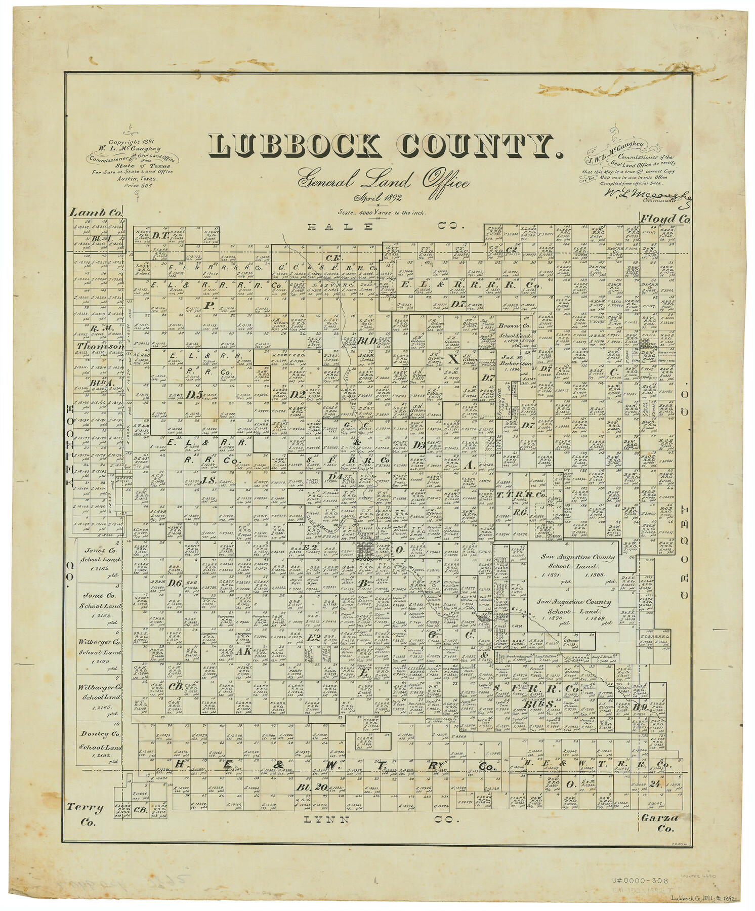
Lubbock County
-
Map/Doc
66910
-
Collection
General Map Collection
-
Object Dates
4/1892 (Creation Date)
-
People and Organizations
W.L. McGaughey (GLO Commissioner)
F.G. Blau (Draftsman)
-
Counties
Lubbock
-
Subjects
County
-
Height x Width
25.0 x 20.6 inches
63.5 x 52.3 cm
-
Comments
Copyrighted 1891.
Part of: General Map Collection
Colonial Texas. 1822 to 1834.

Print $20.00
- Digital $50.00
Colonial Texas. 1822 to 1834.
1897
Size 12.8 x 16.3 inches
Map/Doc 93410
Flight Mission No. BRA-8M, Frame 68, Jefferson County

Print $20.00
- Digital $50.00
Flight Mission No. BRA-8M, Frame 68, Jefferson County
1953
Size 18.6 x 22.4 inches
Map/Doc 85588
Harrison County Working Sketch 13

Print $20.00
- Digital $50.00
Harrison County Working Sketch 13
1961
Size 32.4 x 37.0 inches
Map/Doc 66033
Lampasas County Boundary File Index

Print $2.00
- Digital $50.00
Lampasas County Boundary File Index
Size 9.0 x 9.6 inches
Map/Doc 56092
San Patricio County Rolled Sketch 29

Print $20.00
- Digital $50.00
San Patricio County Rolled Sketch 29
Size 39.2 x 45.5 inches
Map/Doc 9893
Liberty County Working Sketch 79

Print $40.00
- Digital $50.00
Liberty County Working Sketch 79
1981
Size 63.7 x 41.4 inches
Map/Doc 70539
El Paso County Rolled Sketch 37

Print $40.00
- Digital $50.00
El Paso County Rolled Sketch 37
1916
Size 42.8 x 77.0 inches
Map/Doc 76181
Flight Mission No. BRA-16M, Frame 163, Jefferson County

Print $20.00
- Digital $50.00
Flight Mission No. BRA-16M, Frame 163, Jefferson County
1953
Size 18.6 x 22.3 inches
Map/Doc 85761
Atascosa County Working Sketch 30

Print $20.00
- Digital $50.00
Atascosa County Working Sketch 30
1980
Size 16.4 x 20.6 inches
Map/Doc 67226
Culberson County Rolled Sketch 34

Print $20.00
- Digital $50.00
Culberson County Rolled Sketch 34
1938
Size 43.5 x 43.6 inches
Map/Doc 8749
Office Sketch of surveys on St. Joseph and Mustang Islands, Aransas, and Nueces Counties

Print $20.00
- Digital $50.00
Office Sketch of surveys on St. Joseph and Mustang Islands, Aransas, and Nueces Counties
1957
Size 42.6 x 18.0 inches
Map/Doc 1920
Current Miscellaneous File 12

Print $34.00
- Digital $50.00
Current Miscellaneous File 12
1951
Size 10.7 x 8.2 inches
Map/Doc 73803
You may also like
Gulf of Mexico

Print $20.00
- Digital $50.00
Gulf of Mexico
1900
Size 18.2 x 28.1 inches
Map/Doc 72647
Flight Mission No. DQN-2K, Frame 34, Calhoun County

Print $20.00
- Digital $50.00
Flight Mission No. DQN-2K, Frame 34, Calhoun County
1953
Size 18.5 x 22.2 inches
Map/Doc 84241
Gaines County Working Sketch 36

Print $20.00
- Digital $50.00
Gaines County Working Sketch 36
Size 23.5 x 36.7 inches
Map/Doc 69336
Flight Mission No. BRE-2P, Frame 25, Nueces County

Print $20.00
- Digital $50.00
Flight Mission No. BRE-2P, Frame 25, Nueces County
1956
Size 18.4 x 22.2 inches
Map/Doc 86734
Val Verde County Working Sketch 104

Print $20.00
- Digital $50.00
Val Verde County Working Sketch 104
1982
Size 26.4 x 19.0 inches
Map/Doc 72239
Hale County Working Sketch 7

Print $20.00
- Digital $50.00
Hale County Working Sketch 7
1963
Size 24.4 x 20.6 inches
Map/Doc 63327
Val Verde County Sketch File 29

Print $20.00
- Digital $50.00
Val Verde County Sketch File 29
Size 33.1 x 23.8 inches
Map/Doc 76760
Americae nova Tabula

Print $20.00
- Digital $50.00
Americae nova Tabula
1635
Size 18.4 x 24.3 inches
Map/Doc 93812
Flight Mission No. DQO-8K, Frame 40, Galveston County

Print $20.00
- Digital $50.00
Flight Mission No. DQO-8K, Frame 40, Galveston County
1952
Size 18.5 x 22.3 inches
Map/Doc 85147
Parker County Rolled Sketch 3

Print $20.00
- Digital $50.00
Parker County Rolled Sketch 3
1975
Size 22.7 x 18.3 inches
Map/Doc 7204
Crosby County Boundary File 4a

Print $30.00
- Digital $50.00
Crosby County Boundary File 4a
Size 8.8 x 32.8 inches
Map/Doc 52028
Williamson County Rolled Sketch 8

Print $20.00
- Digital $50.00
Williamson County Rolled Sketch 8
Size 15.1 x 18.0 inches
Map/Doc 8265