Pecos County Sketch File 66
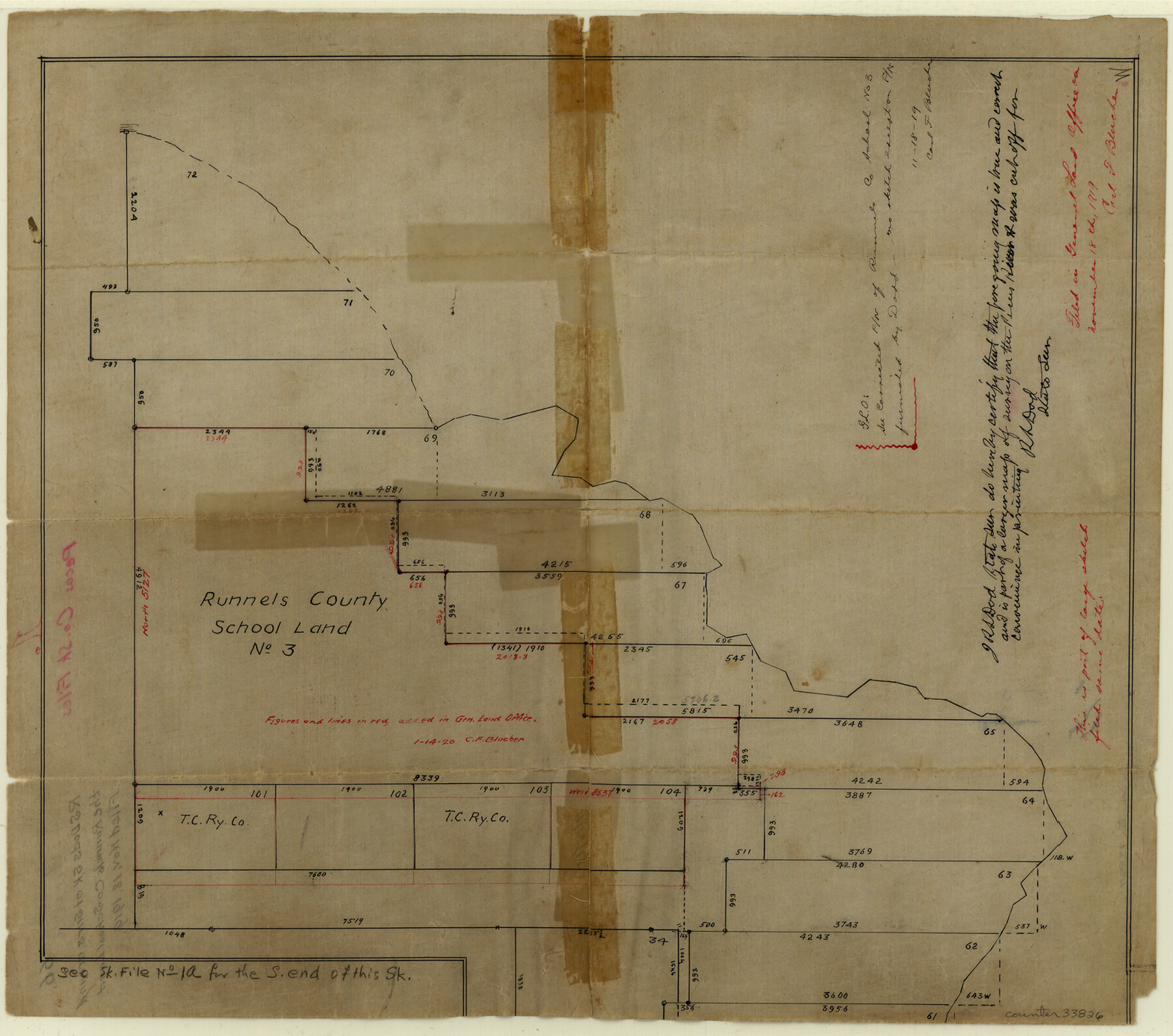
[Sketch of surveys around the Runnels County School Land]
-
Map/Doc
33826
-
Collection
General Map Collection
-
Object Dates
11/18/1919 (File Date)
-
People and Organizations
R.S. Dod (Surveyor/Engineer)
-
Counties
Pecos
-
Subjects
Surveying Sketch File
-
Height x Width
14.3 x 16.2 inches
36.3 x 41.2 cm
-
Medium
paper, manuscript
-
Comments
See Pecos County Sketch File 1A(12155) for south end of this sketch.
Related maps
Pecos County Sketch File 1A

Print $20.00
- Digital $50.00
Pecos County Sketch File 1A
1919
Size 34.3 x 23.7 inches
Map/Doc 12155
Part of: General Map Collection
[Surveys in Vehlein's Colony along the San Jacinto River and Cedar Bayou]
![75, [Surveys in Vehlein's Colony along the San Jacinto River and Cedar Bayou], General Map Collection](https://historictexasmaps.com/wmedia_w700/maps/75.tif.jpg)
Print $20.00
- Digital $50.00
[Surveys in Vehlein's Colony along the San Jacinto River and Cedar Bayou]
1837
Size 17.5 x 15.1 inches
Map/Doc 75
Flight Mission No. DQO-1K, Frame 38, Galveston County

Print $20.00
- Digital $50.00
Flight Mission No. DQO-1K, Frame 38, Galveston County
1952
Size 18.0 x 17.6 inches
Map/Doc 84981
Nueces County Sketch File 25a

Print $6.00
- Digital $50.00
Nueces County Sketch File 25a
1890
Size 14.2 x 8.4 inches
Map/Doc 32578
Wichita County Rolled Sketch 17

Print $117.00
- Digital $50.00
Wichita County Rolled Sketch 17
Size 10.4 x 15.4 inches
Map/Doc 49488

Aransas Pass to Baffin Bay

Print $20.00
- Digital $50.00
Aransas Pass to Baffin Bay
1966
Size 42.3 x 35.0 inches
Map/Doc 73415
Boundary and Ownership map, Laguna Atascosa National Wildlife Refuge, Cameron and Willacy Counties, Texas

Print $40.00
- Digital $50.00
Boundary and Ownership map, Laguna Atascosa National Wildlife Refuge, Cameron and Willacy Counties, Texas
Size 72.7 x 43.0 inches
Map/Doc 60396
Trinity County Sketch File 43

Print $40.00
- Digital $50.00
Trinity County Sketch File 43
1854
Size 19.2 x 23.6 inches
Map/Doc 12495
Atascosa County Sketch File 16

Print $4.00
- Digital $50.00
Atascosa County Sketch File 16
1877
Size 12.2 x 7.9 inches
Map/Doc 13779
Galveston Bay & Texas Land Company Scrip No. 6086

Print $20.00
- Digital $50.00
Galveston Bay & Texas Land Company Scrip No. 6086
1830
Size 12.7 x 8.2 inches
Map/Doc 96568
Fisher County Sketch File A

Print $20.00
- Digital $50.00
Fisher County Sketch File A
1901
Size 33.1 x 22.8 inches
Map/Doc 11482
Map of section no. 3 of a survey of Padre Island made for the Office of the Attorney General of the State of Texas

Print $40.00
- Digital $50.00
Map of section no. 3 of a survey of Padre Island made for the Office of the Attorney General of the State of Texas
1941
Size 49.6 x 40.2 inches
Map/Doc 2259
You may also like
Dimmit County Working Sketch 34

Print $20.00
- Digital $50.00
Dimmit County Working Sketch 34
1959
Size 22.8 x 17.0 inches
Map/Doc 68695
Flight Mission No. DQN-1K, Frame 33, Calhoun County

Print $20.00
- Digital $50.00
Flight Mission No. DQN-1K, Frame 33, Calhoun County
1953
Size 15.5 x 15.5 inches
Map/Doc 84138

Brown County Sketch File 5

Print $40.00
- Digital $50.00
Brown County Sketch File 5
1858
Size 17.9 x 15.8 inches
Map/Doc 11017
Flight Mission No. BRE-2P, Frame 62, Nueces County

Print $20.00
- Digital $50.00
Flight Mission No. BRE-2P, Frame 62, Nueces County
1956
Size 18.3 x 22.5 inches
Map/Doc 86757
Franklin County Working Sketch 4

Print $20.00
- Digital $50.00
Franklin County Working Sketch 4
1999
Size 19.2 x 16.6 inches
Map/Doc 69242
Hopkins County Sketch File 1

Print $4.00
- Digital $50.00
Hopkins County Sketch File 1
1854
Size 5.2 x 10.2 inches
Map/Doc 26676
[East line of Captiol Land in Deaf Smith, Castro and Lamb]
![90603, [East line of Captiol Land in Deaf Smith, Castro and Lamb], Twichell Survey Records](https://historictexasmaps.com/wmedia_w700/maps/90603-1.tif.jpg)
Print $20.00
- Digital $50.00
[East line of Captiol Land in Deaf Smith, Castro and Lamb]
Size 45.4 x 17.4 inches
Map/Doc 90603
Flight Mission No. BRE-2P, Frame 111, Nueces County

Print $20.00
- Digital $50.00
Flight Mission No. BRE-2P, Frame 111, Nueces County
1956
Size 18.4 x 22.6 inches
Map/Doc 86797
Jackson County Rolled Sketch 3A

Print $20.00
- Digital $50.00
Jackson County Rolled Sketch 3A
1913
Size 23.2 x 22.6 inches
Map/Doc 6337
Karnes County Sketch File 8

Print $78.00
- Digital $50.00
Karnes County Sketch File 8
1876
Size 12.7 x 8.2 inches
Map/Doc 28565
Gregg County Working Sketch 23

Print $20.00
- Digital $50.00
Gregg County Working Sketch 23
1982
Size 20.2 x 42.2 inches
Map/Doc 63290