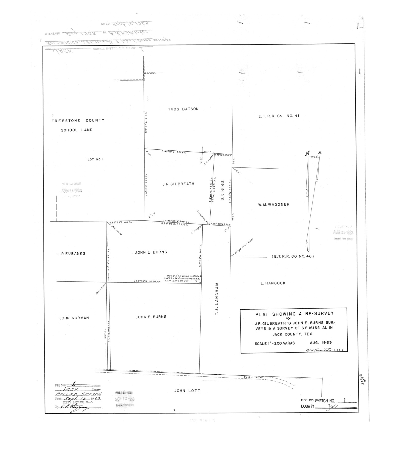
Jack County Rolled Sketch 1
Plat showing a re-survey of J.R. Galbreath & John E. Burns surveys & a survey of SF-16162
-
Map/Doc
6331
-
Collection
General Map Collection
-
Object Dates
1963 (Creation Date)
1963/9/12 (File Date)
-
People and Organizations
B.W. Karsteter (Surveyor/Engineer)
-
Counties
Jack
-
Subjects
Surveying Rolled Sketch
-
Height x Width
24.4 x 22.5 inches
62.0 x 57.2 cm
-
Scale
1" = 200 varas
-
Comments
See Jack County Sketch File 37 (27615) for certificate of filing from Jack County.
Related maps
Jack County Sketch File 37

Print $4.00
- Digital $50.00
Jack County Sketch File 37
1963
Size 3.5 x 7.6 inches
Map/Doc 27615
Part of: General Map Collection
[Surveys in the Bexar District along the Atascosa Creek]
![221, [Surveys in the Bexar District along the Atascosa Creek], General Map Collection](https://historictexasmaps.com/wmedia_w700/maps/221.tif.jpg)
Print $2.00
- Digital $50.00
[Surveys in the Bexar District along the Atascosa Creek]
1842
Size 5.9 x 5.9 inches
Map/Doc 221
Goliad County Working Sketch 7

Print $20.00
- Digital $50.00
Goliad County Working Sketch 7
1937
Size 35.0 x 32.9 inches
Map/Doc 63197
Crockett County Rolled Sketch 92

Print $20.00
- Digital $50.00
Crockett County Rolled Sketch 92
1977
Size 43.0 x 25.2 inches
Map/Doc 5632
Bastrop County Working Sketch 6

Print $20.00
- Digital $50.00
Bastrop County Working Sketch 6
1923
Size 37.5 x 31.2 inches
Map/Doc 67306
Flight Mission No. CRC-5R, Frame 21, Chambers County

Print $20.00
- Digital $50.00
Flight Mission No. CRC-5R, Frame 21, Chambers County
1956
Size 18.6 x 22.3 inches
Map/Doc 84943
Right of Way and Track Map, Texas & New Orleans R.R. Co. operated by the T. & N. O. R.R. Co., Dallas-Sabine Branch

Print $40.00
- Digital $50.00
Right of Way and Track Map, Texas & New Orleans R.R. Co. operated by the T. & N. O. R.R. Co., Dallas-Sabine Branch
1918
Size 24.6 x 56.4 inches
Map/Doc 64632
Trinity County Sketch File 19

Print $20.00
- Digital $50.00
Trinity County Sketch File 19
Size 16.6 x 16.7 inches
Map/Doc 12484
Pecos County Working Sketch 127

Print $40.00
- Digital $50.00
Pecos County Working Sketch 127
1974
Size 76.7 x 37.8 inches
Map/Doc 71601
Menard County Sketch File 7

Print $4.00
- Digital $50.00
Menard County Sketch File 7
Size 5.8 x 12.0 inches
Map/Doc 31492
Bandera County Rolled Sketch 1

Print $20.00
- Digital $50.00
Bandera County Rolled Sketch 1
1945
Size 16.5 x 16.0 inches
Map/Doc 5113
Atascosa County Sketch File 14

Print $40.00
- Digital $50.00
Atascosa County Sketch File 14
1870
Size 12.5 x 15.0 inches
Map/Doc 13773
Pecos County Sketch File 77

Print $4.00
- Digital $50.00
Pecos County Sketch File 77
1943
Size 11.2 x 8.7 inches
Map/Doc 33909
You may also like
Controlled Mosaic by Jack Amman Photogrammetric Engineers, Inc - Sheet 29

Print $20.00
- Digital $50.00
Controlled Mosaic by Jack Amman Photogrammetric Engineers, Inc - Sheet 29
1954
Size 20.0 x 24.0 inches
Map/Doc 83482
[Leagues 615, 616, and vicinity]
![91004, [Leagues 615, 616, and vicinity], Twichell Survey Records](https://historictexasmaps.com/wmedia_w700/maps/91004-1.tif.jpg)
Print $20.00
- Digital $50.00
[Leagues 615, 616, and vicinity]
Size 12.9 x 12.3 inches
Map/Doc 91004
Flight Mission No. CUG-2P, Frame 30, Kleberg County

Print $20.00
- Digital $50.00
Flight Mission No. CUG-2P, Frame 30, Kleberg County
1956
Size 18.5 x 22.4 inches
Map/Doc 86195
Dimmit County Sketch File 2

Print $6.00
- Digital $50.00
Dimmit County Sketch File 2
Size 8.6 x 7.9 inches
Map/Doc 21055
San Augustine County Working Sketch 3

Print $20.00
- Digital $50.00
San Augustine County Working Sketch 3
1934
Size 22.9 x 13.6 inches
Map/Doc 63690
Webb County Rolled Sketch 33

Print $20.00
- Digital $50.00
Webb County Rolled Sketch 33
1939
Size 22.8 x 23.9 inches
Map/Doc 8189
Map of Harrison County

Print $20.00
- Digital $50.00
Map of Harrison County
1871
Size 18.0 x 19.1 inches
Map/Doc 1117
Edwards County Working Sketch 60

Print $20.00
- Digital $50.00
Edwards County Working Sketch 60
1954
Size 20.5 x 43.7 inches
Map/Doc 68936
Trinity River, Balltown Sheet/Pilot Grove Creek

Print $20.00
- Digital $50.00
Trinity River, Balltown Sheet/Pilot Grove Creek
1938
Size 40.1 x 33.7 inches
Map/Doc 65196
Howard County Sketch File 15

Print $6.00
- Digital $50.00
Howard County Sketch File 15
Size 11.2 x 8.8 inches
Map/Doc 26875
[Worksheets related to the Wilson Strickland survey and vicinity]
![91269, [Worksheets related to the Wilson Strickland survey and vicinity], Twichell Survey Records](https://historictexasmaps.com/wmedia_w700/maps/91269.tif.jpg)
Print $20.00
- Digital $50.00
[Worksheets related to the Wilson Strickland survey and vicinity]
Size 25.7 x 21.7 inches
Map/Doc 91269
General Highway Map, Coryell County, Texas

Print $20.00
General Highway Map, Coryell County, Texas
1940
Size 18.4 x 25.4 inches
Map/Doc 79059