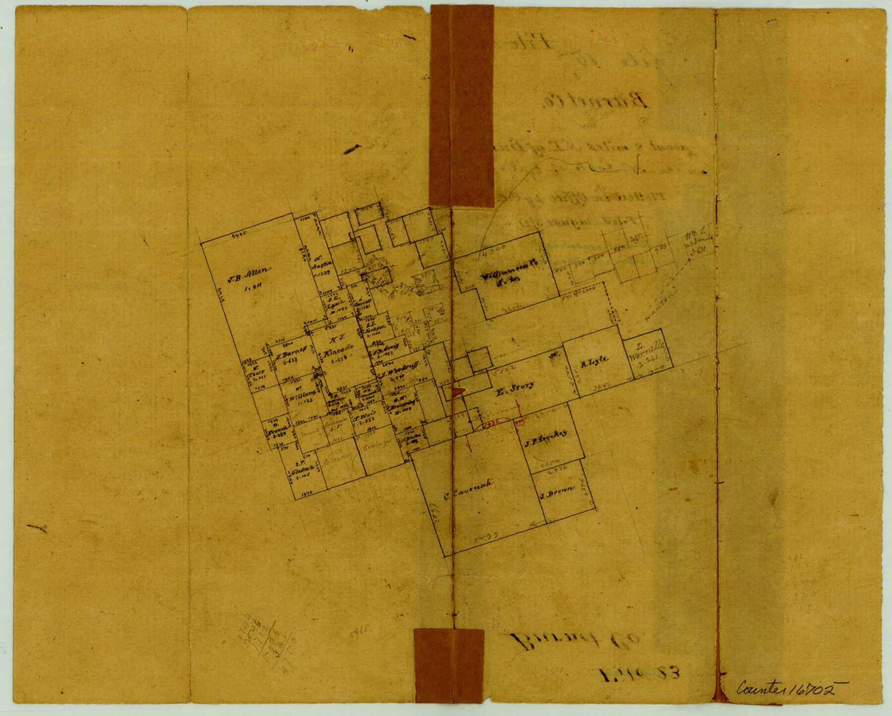
Burnet County Sketch File 15
[Office sketch of surveys northeast of Burnet on the North Fork of San Gabriel River]
-
Map/Doc
16702
-
Collection
General Map Collection
-
Object Dates
1871/8/3 (File Date)
-
People and Organizations
C.C. Stremme (Draftsman)
-
Counties
Burnet
-
Subjects
Surveying Sketch File
-
Height x Width
8.3 x 10.3 inches
21.1 x 26.2 cm
-
Medium
paper, manuscript
Part of: General Map Collection
Hardeman County Sketch File 13

Print $20.00
- Digital $50.00
Hardeman County Sketch File 13
Size 26.3 x 23.7 inches
Map/Doc 11625
Willacy County Working Sketch Graphic Index

Print $20.00
- Digital $50.00
Willacy County Working Sketch Graphic Index
1921
Size 32.8 x 32.7 inches
Map/Doc 76741
Kimble County Sketch File 29 and 30

Print $28.00
- Digital $50.00
Kimble County Sketch File 29 and 30
1936
Size 15.4 x 24.6 inches
Map/Doc 11928
Harris County State Real Property Sketch 3

Print $42.00
- Digital $50.00
Harris County State Real Property Sketch 3
2004
Size 24.9 x 36.9 inches
Map/Doc 81952
Kent County Working Sketch 3b

Print $20.00
- Digital $50.00
Kent County Working Sketch 3b
1948
Size 24.9 x 23.3 inches
Map/Doc 70010
Randall County Sketch File 2

Print $4.00
- Digital $50.00
Randall County Sketch File 2
1913
Size 7.3 x 8.8 inches
Map/Doc 34961
Hays County Working Sketch 13

Print $20.00
- Digital $50.00
Hays County Working Sketch 13
1952
Size 24.2 x 35.0 inches
Map/Doc 66087
Presidio County Rolled Sketch 77

Print $20.00
- Digital $50.00
Presidio County Rolled Sketch 77
1940
Size 47.1 x 43.0 inches
Map/Doc 9778
Denton County Sketch File 3

Print $4.00
- Digital $50.00
Denton County Sketch File 3
1855
Size 12.5 x 8.2 inches
Map/Doc 20688
Jasper County Working Sketch 13

Print $20.00
- Digital $50.00
Jasper County Working Sketch 13
1920
Size 24.3 x 17.1 inches
Map/Doc 66475
Township 2 North Range 12 West, North Western District, Louisiana

Print $20.00
- Digital $50.00
Township 2 North Range 12 West, North Western District, Louisiana
1884
Size 19.6 x 24.7 inches
Map/Doc 65875
Kimble County Sketch File 10

Print $23.00
- Digital $50.00
Kimble County Sketch File 10
Size 18.5 x 15.6 inches
Map/Doc 28931
You may also like
Maverick County Sketch File 9

Print $8.00
- Digital $50.00
Maverick County Sketch File 9
1878
Size 5.3 x 5.6 inches
Map/Doc 31068
Parker County Working Sketch 2

Print $20.00
- Digital $50.00
Parker County Working Sketch 2
1920
Map/Doc 71452
Hartley County Rolled Sketch 8

Print $20.00
- Digital $50.00
Hartley County Rolled Sketch 8
1974
Size 20.0 x 23.7 inches
Map/Doc 6162
Goliad County Sketch File 14

Print $4.00
- Digital $50.00
Goliad County Sketch File 14
1878
Size 8.6 x 11.4 inches
Map/Doc 24243
Platte (sic) of the unorganized County School Lands in the District of Young

Print $20.00
- Digital $50.00
Platte (sic) of the unorganized County School Lands in the District of Young
Size 16.0 x 12.3 inches
Map/Doc 90453
Red River County Sketch File 6

Print $8.00
- Digital $50.00
Red River County Sketch File 6
1853
Size 10.4 x 6.9 inches
Map/Doc 35105

Blanco County Boundary File 53

Print $50.00
- Digital $50.00
Blanco County Boundary File 53
Size 9.2 x 7.7 inches
Map/Doc 50580
Aransas County Rolled Sketch 20

Print $20.00
- Digital $50.00
Aransas County Rolled Sketch 20
Size 43.2 x 47.3 inches
Map/Doc 8414
General Highway Map, Rains County, Wood County, Texas

Print $20.00
General Highway Map, Rains County, Wood County, Texas
1939
Size 18.2 x 24.8 inches
Map/Doc 79223
Dawson County Sketch File 3a

Print $12.00
- Digital $50.00
Dawson County Sketch File 3a
Size 12.9 x 8.3 inches
Map/Doc 20503
Cooke County Boundary File 19

Print $30.00
- Digital $50.00
Cooke County Boundary File 19
Size 8.7 x 4.0 inches
Map/Doc 51858