Hartley County Sketch File 16
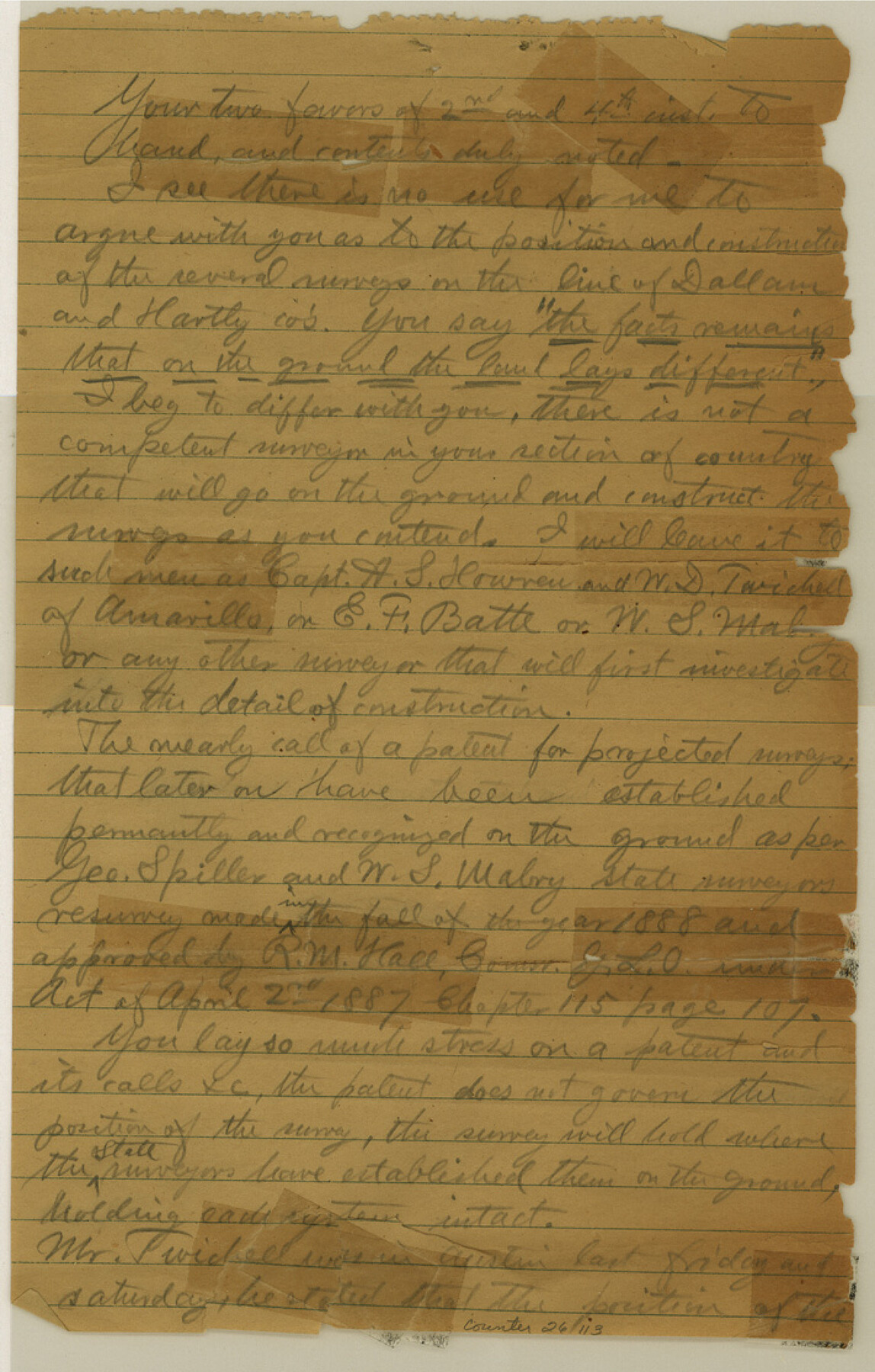
[Letter concerning surveys on line between Dallam and Hartley Counties]
-
Map/Doc
26113
-
Collection
General Map Collection
-
Object Dates
1888 (Survey Date)
-
People and Organizations
George Spiller (Surveyor/Engineer)
W.S. Mabry (Surveyor/Engineer)
-
Counties
Hartley Dallam
-
Subjects
Surveying Sketch File
-
Height x Width
11.1 x 7.1 inches
28.2 x 18.0 cm
-
Medium
paper, manuscript
Part of: General Map Collection
Jeff Davis County Sketch File 36

Print $40.00
- Digital $50.00
Jeff Davis County Sketch File 36
1951
Size 17.1 x 14.3 inches
Map/Doc 28048
Terrell County Working Sketch 41

Print $20.00
- Digital $50.00
Terrell County Working Sketch 41
1957
Size 29.1 x 38.2 inches
Map/Doc 62134
Hopkins County Sketch File 23

Print $4.00
- Digital $50.00
Hopkins County Sketch File 23
1871
Size 12.6 x 8.4 inches
Map/Doc 26732
Nacogdoches County Sketch File 21

Print $20.00
- Digital $50.00
Nacogdoches County Sketch File 21
1837
Size 9.4 x 5.5 inches
Map/Doc 32286
Atascosa County Sketch File 37

Print $40.00
- Digital $50.00
Atascosa County Sketch File 37
Size 17.6 x 12.9 inches
Map/Doc 13829
Morris County Working Sketch 3

Print $20.00
- Digital $50.00
Morris County Working Sketch 3
1958
Size 27.6 x 38.2 inches
Map/Doc 71202
[Surveys in the Milam District Near the Upper San Gabriel River]
![247, [Surveys in the Milam District Near the Upper San Gabriel River], General Map Collection](https://historictexasmaps.com/wmedia_w700/maps/247.tif.jpg)
Print $20.00
- Digital $50.00
[Surveys in the Milam District Near the Upper San Gabriel River]
1845
Size 12.3 x 15.7 inches
Map/Doc 247
[Meanders of a navigable river, perhaps Cow Bayou]
![66, [Meanders of a navigable river, perhaps Cow Bayou], General Map Collection](https://historictexasmaps.com/wmedia_w700/maps/66.tif.jpg)
Print $20.00
- Digital $50.00
[Meanders of a navigable river, perhaps Cow Bayou]
1842
Size 14.0 x 16.6 inches
Map/Doc 66
Brewster County Rolled Sketch 60

Print $40.00
- Digital $50.00
Brewster County Rolled Sketch 60
Size 53.9 x 28.0 inches
Map/Doc 61784
Harris County Rolled Sketch 41(1)

Print $13.00
- Digital $50.00
Harris County Rolled Sketch 41(1)
Size 10.0 x 15.3 inches
Map/Doc 45789
Ward County Working Sketch 2

Print $20.00
- Digital $50.00
Ward County Working Sketch 2
1937
Size 22.9 x 28.7 inches
Map/Doc 72308
Childress County Sketch File 22

Print $32.00
- Digital $50.00
Childress County Sketch File 22
1919
Size 14.3 x 8.7 inches
Map/Doc 18366
You may also like

[Blocks T1, T2, T3, S3, A, 05, 02 and vicinity]
![92196, [Blocks T1, T2, T3, S3, A, 05, 02 and vicinity], Twichell Survey Records](https://historictexasmaps.com/wmedia_w700/maps/92196-1.tif.jpg)
Print $20.00
- Digital $50.00
[Blocks T1, T2, T3, S3, A, 05, 02 and vicinity]
Size 20.3 x 22.9 inches
Map/Doc 92196
1960 Texas Official Highway Travel Map

Digital $50.00
1960 Texas Official Highway Travel Map
Size 28.4 x 36.2 inches
Map/Doc 94329
University of Texas System University Lands

Print $20.00
- Digital $50.00
University of Texas System University Lands
1929
Size 23.2 x 17.7 inches
Map/Doc 93246
Brazoria County NRC Article 33.136 Sketch 7

Print $21.00
- Digital $50.00
Brazoria County NRC Article 33.136 Sketch 7
2004
Size 23.7 x 33.3 inches
Map/Doc 82907
Map Defining Three Positions for North Line of Wilson Strickland

Print $20.00
- Digital $50.00
Map Defining Three Positions for North Line of Wilson Strickland
Size 25.5 x 10.7 inches
Map/Doc 91284
[Blocks M25, M22, R, and vicinity]
![91240, [Blocks M25, M22, R, and vicinity], Twichell Survey Records](https://historictexasmaps.com/wmedia_w700/maps/91240-1.tif.jpg)
Print $20.00
- Digital $50.00
[Blocks M25, M22, R, and vicinity]
1922
Size 29.0 x 25.7 inches
Map/Doc 91240
Newton County Sketch File 2

Print $6.00
- Digital $50.00
Newton County Sketch File 2
Size 14.0 x 10.7 inches
Map/Doc 32358
Harris County Sketch File 12

Print $40.00
- Digital $50.00
Harris County Sketch File 12
1896
Size 16.1 x 12.5 inches
Map/Doc 25353
DeWitt County Sketch File 1

Print $11.00
- Digital $50.00
DeWitt County Sketch File 1
1851
Size 8.4 x 8.2 inches
Map/Doc 20794
Caldwell County Working Sketch 1

Print $20.00
- Digital $50.00
Caldwell County Working Sketch 1
Size 20.7 x 26.2 inches
Map/Doc 67831
Coryell County Working Sketch 6

Print $20.00
- Digital $50.00
Coryell County Working Sketch 6
1941
Size 15.9 x 13.6 inches
Map/Doc 68213