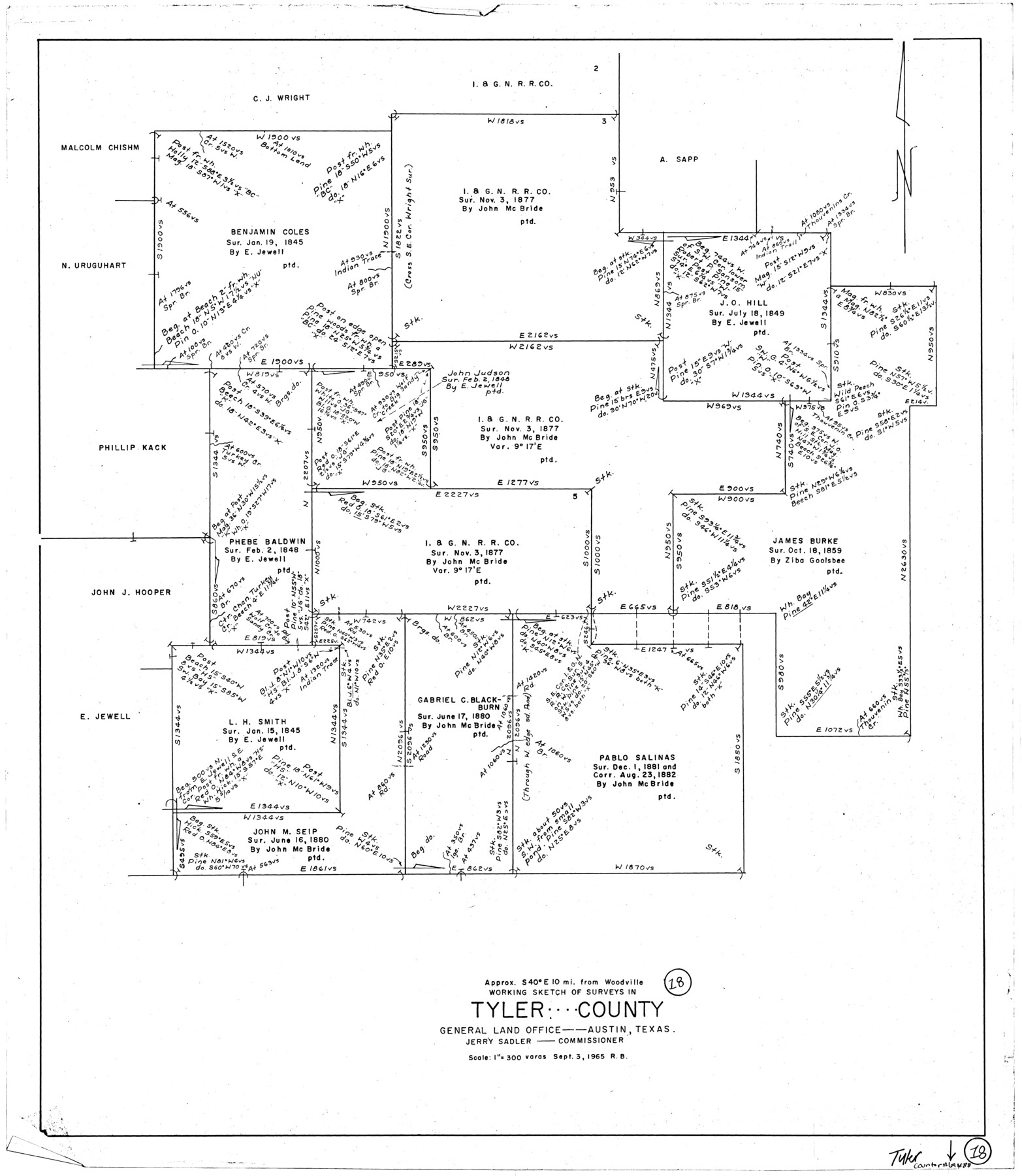
Tyler County Working Sketch 18
-
Map/Doc
69488
-
Collection
General Map Collection
-
Counties
Tyler
-
Subjects
Surveying Working Sketch
-
Height x Width
31.4 x 27.3 inches
79.8 x 69.3 cm
Part of: General Map Collection
Foard County Rolled Sketch 12

Print $20.00
- Digital $50.00
Foard County Rolled Sketch 12
1945
Size 26.8 x 19.7 inches
Map/Doc 5886
Harris County Sketch File 69a

Print $20.00
- Digital $50.00
Harris County Sketch File 69a
1938
Size 19.4 x 21.3 inches
Map/Doc 11663
Pecos County Working Sketch 36

Print $20.00
- Digital $50.00
Pecos County Working Sketch 36
1939
Size 47.4 x 38.8 inches
Map/Doc 71508
Gregg County Working Sketch 1

Print $20.00
- Digital $50.00
Gregg County Working Sketch 1
1930
Size 14.9 x 15.3 inches
Map/Doc 63267
Carta Etnografica

Print $20.00
- Digital $50.00
Carta Etnografica
1897
Size 26.2 x 34.1 inches
Map/Doc 96798
Nueces County Rolled Sketch 34

Print $20.00
- Digital $50.00
Nueces County Rolled Sketch 34
1951
Size 47.9 x 37.5 inches
Map/Doc 9601
Gregg County Rolled Sketch 20

Print $20.00
- Digital $50.00
Gregg County Rolled Sketch 20
1957
Size 34.0 x 44.4 inches
Map/Doc 9070
Orange County Working Sketch 16

Print $20.00
- Digital $50.00
Orange County Working Sketch 16
1929
Size 25.0 x 24.2 inches
Map/Doc 71348
McLennan County Sketch File 21

Print $4.00
- Digital $50.00
McLennan County Sketch File 21
Size 9.0 x 8.2 inches
Map/Doc 31294
Hunt County Rolled Sketch 5

Print $20.00
- Digital $50.00
Hunt County Rolled Sketch 5
1956
Size 27.5 x 24.3 inches
Map/Doc 6269
Jasper County Sketch File 13

Print $4.00
- Digital $50.00
Jasper County Sketch File 13
1880
Size 12.1 x 8.7 inches
Map/Doc 27804
Wise County Working Sketch 18

Print $20.00
- Digital $50.00
Wise County Working Sketch 18
Size 32.8 x 46.5 inches
Map/Doc 72632
You may also like
[Portion of Block 178, Block C3 and Sections 48-65, Block 1, I. & G. N.]
![91648, [Portion of Block 178, Block C3 and Sections 48-65, Block 1, I. & G. N.], Twichell Survey Records](https://historictexasmaps.com/wmedia_w700/maps/91648-1.tif.jpg)
Print $2.00
- Digital $50.00
[Portion of Block 178, Block C3 and Sections 48-65, Block 1, I. & G. N.]
Size 9.1 x 14.7 inches
Map/Doc 91648
Map of Copano, St. Charles, Aransas & Red Fish Bays in Aransas & Nueces Counties showing subdivision thereof for mineral development

Print $40.00
- Digital $50.00
Map of Copano, St. Charles, Aransas & Red Fish Bays in Aransas & Nueces Counties showing subdivision thereof for mineral development
Size 57.9 x 42.7 inches
Map/Doc 65805

Map of The Surveyed Part of Peters Colony Texas

Print $40.00
- Digital $50.00
Map of The Surveyed Part of Peters Colony Texas
1852
Size 56.5 x 41.0 inches
Map/Doc 1966
Map of surveys 191 & 192 T. C. R.R. Co. in Travis County, Texas

Print $20.00
- Digital $50.00
Map of surveys 191 & 192 T. C. R.R. Co. in Travis County, Texas
1915
Size 20.6 x 13.6 inches
Map/Doc 75554
Upshur County Sketch File 13A

Print $20.00
- Digital $50.00
Upshur County Sketch File 13A
1936
Size 20.5 x 32.4 inches
Map/Doc 12503
Liberty County Sketch File 58

Print $2.00
- Digital $50.00
Liberty County Sketch File 58
Size 8.9 x 7.7 inches
Map/Doc 30060
Gaines County

Print $40.00
- Digital $50.00
Gaines County
1902
Size 49.7 x 38.6 inches
Map/Doc 89863
Coke County Sketch File 9

Print $4.00
- Digital $50.00
Coke County Sketch File 9
Size 12.6 x 7.9 inches
Map/Doc 18585
Wichita County Working Sketch 3

Print $20.00
- Digital $50.00
Wichita County Working Sketch 3
Size 22.2 x 15.6 inches
Map/Doc 72512
Three Sitios of Land Granted to Vicente Micheli April 28th 1806

Print $2.00
- Digital $50.00
Three Sitios of Land Granted to Vicente Micheli April 28th 1806
1835
Size 11.8 x 8.1 inches
Map/Doc 170
[Map of the Houston and G. N. R.R. and lands adjacent, from Troupe to the Texas Pacific R.R.]
![64628, [Map of the Houston and G. N. R.R. and lands adjacent, from Troupe to the Texas Pacific R.R.], General Map Collection](https://historictexasmaps.com/wmedia_w700/maps/64628.tif.jpg)
Print $40.00
- Digital $50.00
[Map of the Houston and G. N. R.R. and lands adjacent, from Troupe to the Texas Pacific R.R.]
1873
Size 20.2 x 49.3 inches
Map/Doc 64628