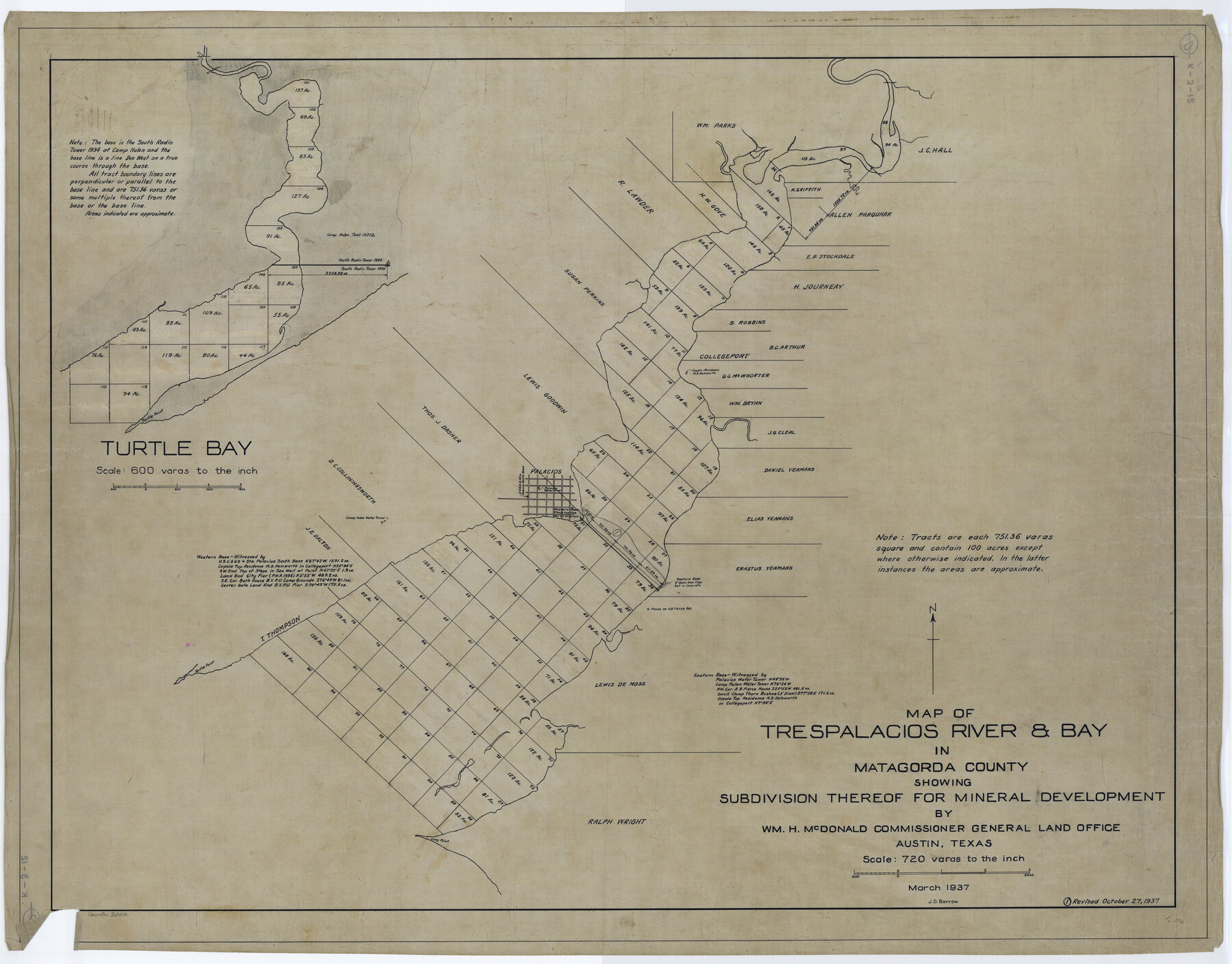
Map of Trespalacios River & Bay in Matagorda County showing subdivision thereof for mineral development
K-3-12
-
Map/Doc
3022
-
Collection
General Map Collection
-
Object Dates
1937 (Creation Date)
-
People and Organizations
General Land Office (Publisher)
-
Subjects
Energy Offshore Submerged Area
-
Height x Width
30.5 x 38.9 inches
77.5 x 98.8 cm
Part of: General Map Collection
El Paso County Boundary File 3

Print $6.00
- Digital $50.00
El Paso County Boundary File 3
Size 9.7 x 6.1 inches
Map/Doc 53035
[Aerial photograph from Carancahua Bend of Caney Creek to Cedar Lake]
![78641, [Aerial photograph from Carancahua Bend of Caney Creek to Cedar Lake], General Map Collection](https://historictexasmaps.com/wmedia_w700/maps/78641.tif.jpg)
Print $20.00
- Digital $50.00
[Aerial photograph from Carancahua Bend of Caney Creek to Cedar Lake]
1991
Size 24.5 x 31.9 inches
Map/Doc 78641
El Paso County Boundary File 10

Print $14.00
- Digital $50.00
El Paso County Boundary File 10
Size 12.7 x 8.2 inches
Map/Doc 53118
Hays County Sketch File 15

Print $40.00
- Digital $50.00
Hays County Sketch File 15
1871
Size 12.0 x 16.6 inches
Map/Doc 26225
Mason County Rolled Sketch 2

Print $20.00
- Digital $50.00
Mason County Rolled Sketch 2
1952
Size 32.9 x 26.7 inches
Map/Doc 6675
Carson County Working Sketch 5

Print $20.00
- Digital $50.00
Carson County Working Sketch 5
1979
Size 42.2 x 14.5 inches
Map/Doc 67876
Oldham County Sketch File 15

Print $6.00
- Digital $50.00
Oldham County Sketch File 15
1904
Size 11.2 x 8.5 inches
Map/Doc 33261
Wichita County Working Sketch 19

Print $20.00
- Digital $50.00
Wichita County Working Sketch 19
1949
Size 18.1 x 30.9 inches
Map/Doc 72529
Midland County Working Sketch 23

Print $40.00
- Digital $50.00
Midland County Working Sketch 23
1956
Size 45.0 x 75.6 inches
Map/Doc 71004
Clay County Sketch File 7

Print $2.00
- Digital $50.00
Clay County Sketch File 7
Size 8.2 x 3.5 inches
Map/Doc 18397
Flight Mission No. BRA-7M, Frame 119, Jefferson County

Print $20.00
- Digital $50.00
Flight Mission No. BRA-7M, Frame 119, Jefferson County
1953
Size 18.5 x 22.4 inches
Map/Doc 85513
Gulf Intracoastal Waterway - Texas Erosion at the West End of Bolivar Peninsula Comparative Shorelines

Print $20.00
- Digital $50.00
Gulf Intracoastal Waterway - Texas Erosion at the West End of Bolivar Peninsula Comparative Shorelines
1950
Size 29.0 x 40.3 inches
Map/Doc 61826
You may also like
Sketch showing Damon's Mound and adjacent surveys

Print $20.00
- Digital $50.00
Sketch showing Damon's Mound and adjacent surveys
Size 19.4 x 17.7 inches
Map/Doc 90218
Ward County Rolled Sketch 15

Print $20.00
- Digital $50.00
Ward County Rolled Sketch 15
1941
Size 26.9 x 39.2 inches
Map/Doc 8158
West Part of Jeff Davis Co.

Print $20.00
- Digital $50.00
West Part of Jeff Davis Co.
1977
Size 35.0 x 45.2 inches
Map/Doc 73195
Castro County Working Sketch Graphic Index

Print $20.00
- Digital $50.00
Castro County Working Sketch Graphic Index
1932
Size 43.1 x 38.2 inches
Map/Doc 76490
Flight Mission No. DCL-6C, Frame 7, Kenedy County

Print $20.00
- Digital $50.00
Flight Mission No. DCL-6C, Frame 7, Kenedy County
1943
Size 18.6 x 22.4 inches
Map/Doc 85867
Flight Mission No. BRA-16M, Frame 146, Jefferson County

Print $20.00
- Digital $50.00
Flight Mission No. BRA-16M, Frame 146, Jefferson County
1953
Size 18.4 x 22.3 inches
Map/Doc 85752
Kimble County Working Sketch 46

Print $20.00
- Digital $50.00
Kimble County Working Sketch 46
1951
Size 29.3 x 18.9 inches
Map/Doc 70114
Deaf Smith County Working Sketch 5

Print $40.00
- Digital $50.00
Deaf Smith County Working Sketch 5
1983
Size 37.0 x 53.9 inches
Map/Doc 68645
Montgomery County Sketch File 28

Print $22.00
- Digital $50.00
Montgomery County Sketch File 28
Size 14.1 x 8.7 inches
Map/Doc 31873
Enoch's Land Situated in Bailey and Cochran Counties, Texas

Print $20.00
- Digital $50.00
Enoch's Land Situated in Bailey and Cochran Counties, Texas
1925
Size 29.1 x 35.7 inches
Map/Doc 92515
Flight Mission No. DAG-18K, Frame 76, Matagorda County

Print $20.00
- Digital $50.00
Flight Mission No. DAG-18K, Frame 76, Matagorda County
1952
Size 17.5 x 22.1 inches
Map/Doc 86369
Pecos County Rolled Sketch 78

Print $40.00
- Digital $50.00
Pecos County Rolled Sketch 78
1930
Size 52.6 x 44.1 inches
Map/Doc 9705