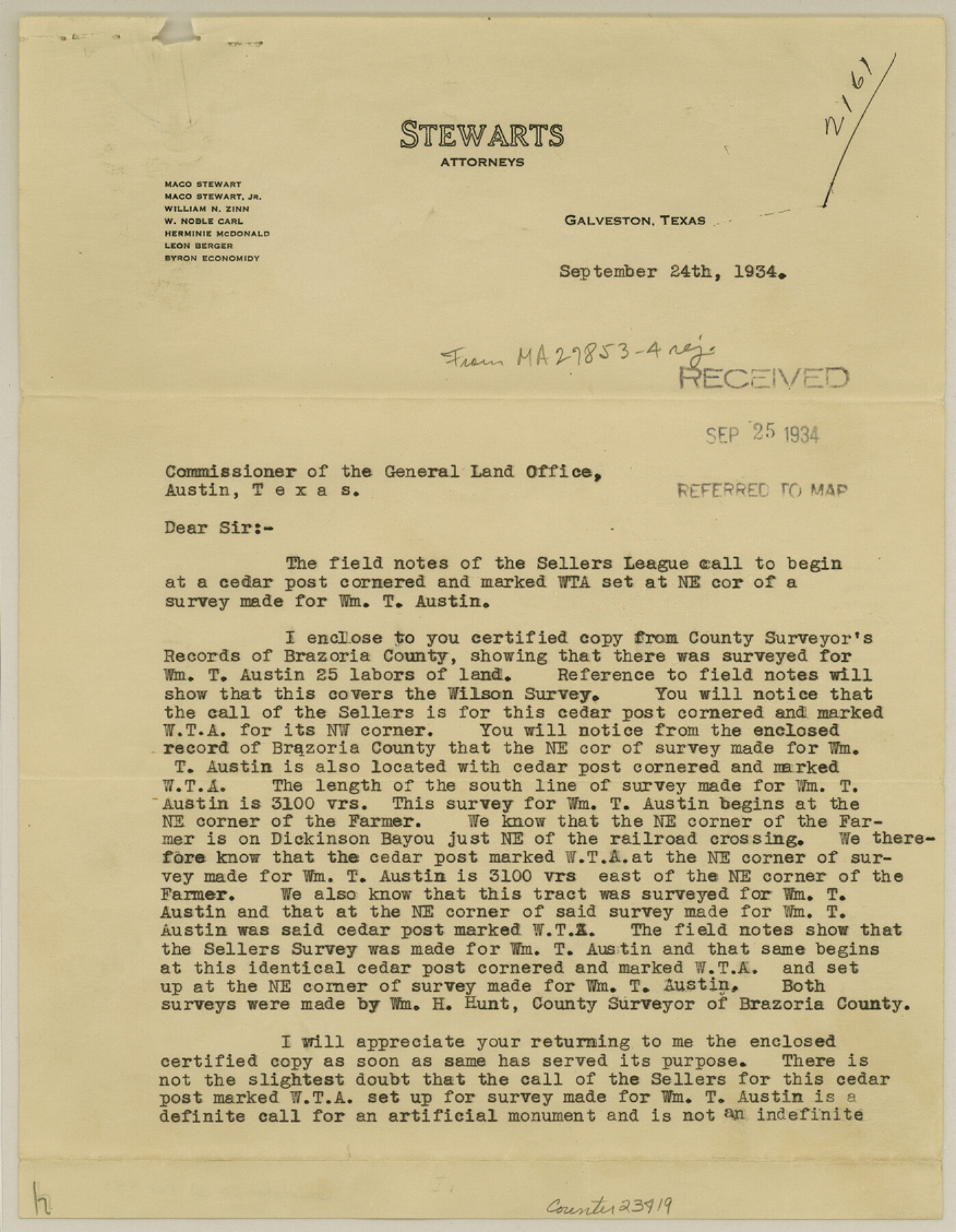
Galveston County Sketch File 35
[Copy of Wm. T. Austin's field notes of 1838]
-
Map/Doc
23419
-
Collection
General Map Collection
-
Object Dates
1934/9/25 (Creation Date)
1838/3/21 (Creation Date)
-
People and Organizations
Maco Stewart (Surveyor/Engineer)
William H. Hunt (Surveyor/Engineer)
William Kannady (Chainman)
Spencer Brooke (Chainman)
-
Counties
Galveston Brazoria
-
Subjects
Surveying Sketch File
-
Height x Width
11.3 x 8.8 inches
28.7 x 22.4 cm
-
Medium
paper, print
-
Features
Dickinson Bayou
Part of: General Map Collection
Flight Mission No. CRC-5R, Frame 40, Chambers County

Print $20.00
- Digital $50.00
Flight Mission No. CRC-5R, Frame 40, Chambers County
1956
Size 18.6 x 22.4 inches
Map/Doc 84959
Gaines County Sketch File 19

Print $8.00
- Digital $50.00
Gaines County Sketch File 19
1989
Size 11.3 x 8.8 inches
Map/Doc 23331
[Sketch for Mineral Application 27669 - Trinity River, Frank R. Graves]
![2858, [Sketch for Mineral Application 27669 - Trinity River, Frank R. Graves], General Map Collection](https://historictexasmaps.com/wmedia_w700/maps/2858-1.tif.jpg)
Print $40.00
- Digital $50.00
[Sketch for Mineral Application 27669 - Trinity River, Frank R. Graves]
1934
Size 28.3 x 83.2 inches
Map/Doc 2858
Baylor County

Print $40.00
- Digital $50.00
Baylor County
1917
Size 48.1 x 40.2 inches
Map/Doc 66714
Robertson County Working Sketch Graphic Index

Print $20.00
- Digital $50.00
Robertson County Working Sketch Graphic Index
1945
Size 46.8 x 37.9 inches
Map/Doc 76685
Flight Mission No. BRE-2P, Frame 98, Nueces County

Print $20.00
- Digital $50.00
Flight Mission No. BRE-2P, Frame 98, Nueces County
1956
Size 18.5 x 22.4 inches
Map/Doc 86783
Flight Mission No. BRA-7M, Frame 83, Jefferson County

Print $20.00
- Digital $50.00
Flight Mission No. BRA-7M, Frame 83, Jefferson County
1953
Size 16.1 x 16.1 inches
Map/Doc 85505
Cherokee County Working Sketch 18

Print $40.00
- Digital $50.00
Cherokee County Working Sketch 18
1958
Size 74.6 x 43.6 inches
Map/Doc 67973
United States - Gulf Coast - From Latitude 26° 33' to the Rio Grande Texas

Print $20.00
- Digital $50.00
United States - Gulf Coast - From Latitude 26° 33' to the Rio Grande Texas
1916
Size 27.8 x 18.3 inches
Map/Doc 72837
Pecos County Rolled Sketch 46

Print $3.00
- Digital $50.00
Pecos County Rolled Sketch 46
1913
Size 13.4 x 9.7 inches
Map/Doc 7224
Wichita County Sketch File 3

Print $8.00
- Digital $50.00
Wichita County Sketch File 3
1856
Size 7.2 x 16.3 inches
Map/Doc 40033
Montgomery County Working Sketch 56

Print $20.00
- Digital $50.00
Montgomery County Working Sketch 56
1961
Size 21.2 x 24.0 inches
Map/Doc 71163
You may also like
Terrell County Working Sketch Graphic index - sheet B

Print $20.00
- Digital $50.00
Terrell County Working Sketch Graphic index - sheet B
1931
Size 47.7 x 39.6 inches
Map/Doc 76711
Jackson County Rolled Sketch 12

Print $20.00
- Digital $50.00
Jackson County Rolled Sketch 12
1956
Size 23.9 x 32.7 inches
Map/Doc 6344
Red River County Working Sketch 23

Print $20.00
- Digital $50.00
Red River County Working Sketch 23
1958
Size 30.7 x 26.1 inches
Map/Doc 72006
Map of Washington District

Print $20.00
- Digital $50.00
Map of Washington District
1847
Size 17.6 x 26.8 inches
Map/Doc 4125
Coryell County Sketch File 17

Print $4.00
- Digital $50.00
Coryell County Sketch File 17
1854
Size 6.7 x 8.4 inches
Map/Doc 19375
Coke County Working Sketch 3

Print $20.00
- Digital $50.00
Coke County Working Sketch 3
1890
Size 22.3 x 29.2 inches
Map/Doc 68040
Brazoria County Sketch File 49

Print $20.00
- Digital $50.00
Brazoria County Sketch File 49
Size 14.2 x 8.7 inches
Map/Doc 15112
Callahan County Sketch File 7

Print $18.00
- Digital $50.00
Callahan County Sketch File 7
Size 10.8 x 8.9 inches
Map/Doc 35863
Yoakum County

Print $20.00
- Digital $50.00
Yoakum County
1938
Size 24.9 x 24.6 inches
Map/Doc 92446
Hutchinson County Sketch File 5

Print $60.00
- Digital $50.00
Hutchinson County Sketch File 5
Size 15.1 x 62.7 inches
Map/Doc 10498
Flight Mission No. BRA-6M, Frame 91, Jefferson County

Print $20.00
- Digital $50.00
Flight Mission No. BRA-6M, Frame 91, Jefferson County
1953
Size 18.5 x 22.4 inches
Map/Doc 85434
Caldwell County Working Sketch 8

Print $20.00
- Digital $50.00
Caldwell County Working Sketch 8
1964
Size 29.1 x 22.8 inches
Map/Doc 67838