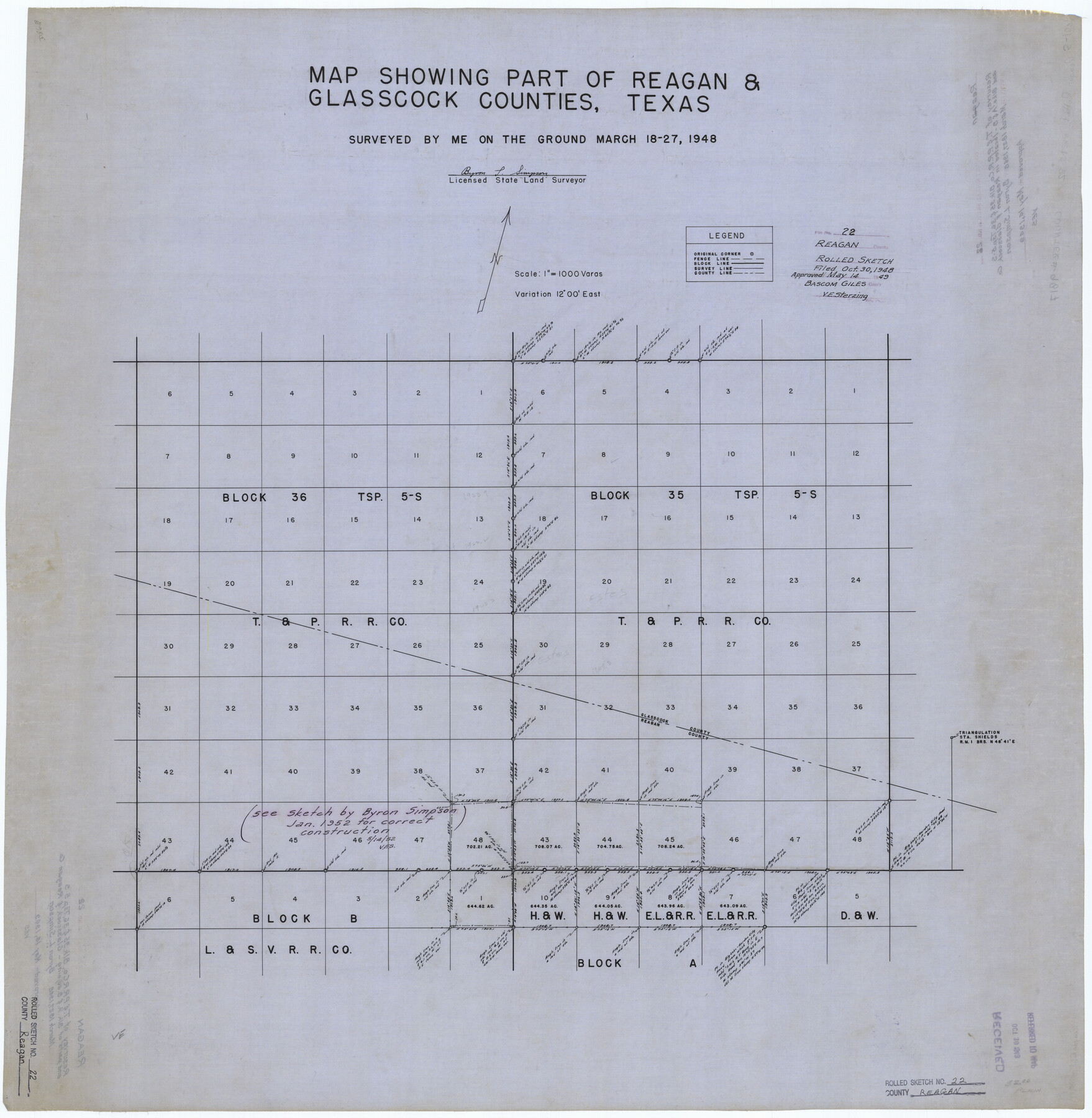
Reagan County Rolled Sketch 22
Map showing part of Reagan & Glasscock Counties, Texas
-
Map/Doc
9817
-
Collection
General Map Collection
-
Object Dates
1948/3/27 (Survey Date)
1948/10/30 (File Date)
-
People and Organizations
Byron L. Simpson (Surveyor/Engineer)
-
Counties
Reagan Glasscock
-
Subjects
Surveying Rolled Sketch
-
Height x Width
33.9 x 33.1 inches
86.1 x 84.1 cm
-
Medium
linen, manuscript
-
Scale
1" = 1000 varas
Part of: General Map Collection
Brooks County Sketch File 3a

Print $5.00
- Digital $50.00
Brooks County Sketch File 3a
Size 14.2 x 9.5 inches
Map/Doc 16542
Hardin County Sketch File 16

Print $8.00
- Digital $50.00
Hardin County Sketch File 16
Size 8.3 x 11.4 inches
Map/Doc 25125
Palo Pinto County Sketch File 26

Print $8.00
- Digital $50.00
Palo Pinto County Sketch File 26
1993
Size 14.0 x 8.6 inches
Map/Doc 33441
[Surveys near Crabapple Creek in the Bexar District]
![87, [Surveys near Crabapple Creek in the Bexar District], General Map Collection](https://historictexasmaps.com/wmedia_w700/maps/87.tif.jpg)
Print $2.00
- Digital $50.00
[Surveys near Crabapple Creek in the Bexar District]
1846
Size 9.1 x 7.0 inches
Map/Doc 87
Val Verde County Sketch File 4

Print $30.00
- Digital $50.00
Val Verde County Sketch File 4
1888
Size 28.0 x 20.6 inches
Map/Doc 12561
Dickens County Rolled Sketch 10

Print $20.00
- Digital $50.00
Dickens County Rolled Sketch 10
Size 43.0 x 31.9 inches
Map/Doc 8789
Zavala County Sketch File 15

Print $20.00
- Digital $50.00
Zavala County Sketch File 15
Size 23.3 x 22.3 inches
Map/Doc 12729
Gaines County Working Sketch 20

Print $20.00
- Digital $50.00
Gaines County Working Sketch 20
1970
Size 44.2 x 44.1 inches
Map/Doc 69320
Kinney County Working Sketch 39

Print $20.00
- Digital $50.00
Kinney County Working Sketch 39
1972
Size 37.7 x 44.8 inches
Map/Doc 70221
Stephens County Working Sketch 33

Print $20.00
- Digital $50.00
Stephens County Working Sketch 33
1978
Size 31.1 x 30.8 inches
Map/Doc 63976
[Surveys in Austin's Colony by Horatio Chriesman along Mill and Cummins Creeks]
![68, [Surveys in Austin's Colony by Horatio Chriesman along Mill and Cummins Creeks], General Map Collection](https://historictexasmaps.com/wmedia_w700/maps/68.tif.jpg)
Print $20.00
- Digital $50.00
[Surveys in Austin's Colony by Horatio Chriesman along Mill and Cummins Creeks]
1830
Size 30.7 x 25.7 inches
Map/Doc 68
Fort Bend County

Print $20.00
- Digital $50.00
Fort Bend County
1865
Size 18.2 x 21.8 inches
Map/Doc 3550
You may also like
Culberson County Rolled Sketch 56

Print $37.00
- Digital $50.00
Culberson County Rolled Sketch 56
1972
Size 11.0 x 15.6 inches
Map/Doc 44267
San Saba County

Print $20.00
- Digital $50.00
San Saba County
1918
Size 46.8 x 41.2 inches
Map/Doc 63022
Flight Mission No. BRE-2P, Frame 44, Nueces County

Print $20.00
- Digital $50.00
Flight Mission No. BRE-2P, Frame 44, Nueces County
1956
Size 18.7 x 22.9 inches
Map/Doc 86746
Travis County

Print $40.00
- Digital $50.00
Travis County
1936
Size 46.9 x 54.1 inches
Map/Doc 95479
Flight Mission No. BRE-1P, Frame 56, Nueces County

Print $20.00
- Digital $50.00
Flight Mission No. BRE-1P, Frame 56, Nueces County
1956
Size 18.5 x 22.4 inches
Map/Doc 86645
Howard County Working Sketch 7a

Print $40.00
- Digital $50.00
Howard County Working Sketch 7a
1950
Size 81.9 x 24.7 inches
Map/Doc 66273
Eastland County Sketch File 2b

Print $6.00
- Digital $50.00
Eastland County Sketch File 2b
1857
Size 11.1 x 8.8 inches
Map/Doc 21563
Duval County Sketch File 73

Print $4.00
- Digital $50.00
Duval County Sketch File 73
Size 9.9 x 8.8 inches
Map/Doc 21463
Dimmit County Sketch File 36

Print $6.00
- Digital $50.00
Dimmit County Sketch File 36
1894
Size 4.3 x 13.3 inches
Map/Doc 21158
[Sketch for Mineral Application 13441 - Trinity River, Miller's Lake, Charlotte Lake, Florence Dunn]
![65657, [Sketch for Mineral Application 13441 - Trinity River, Miller's Lake, Charlotte Lake, Florence Dunn], General Map Collection](https://historictexasmaps.com/wmedia_w700/maps/65657.tif.jpg)
Print $40.00
- Digital $50.00
[Sketch for Mineral Application 13441 - Trinity River, Miller's Lake, Charlotte Lake, Florence Dunn]
1925
Size 104.1 x 43.3 inches
Map/Doc 65657
Houston County Working Sketch 37

Print $20.00
- Digital $50.00
Houston County Working Sketch 37
2006
Size 33.0 x 40.0 inches
Map/Doc 83627
Highland Lakes of Central Texas

Print $20.00
- Digital $50.00
Highland Lakes of Central Texas
1947
Size 18.2 x 21.9 inches
Map/Doc 60291