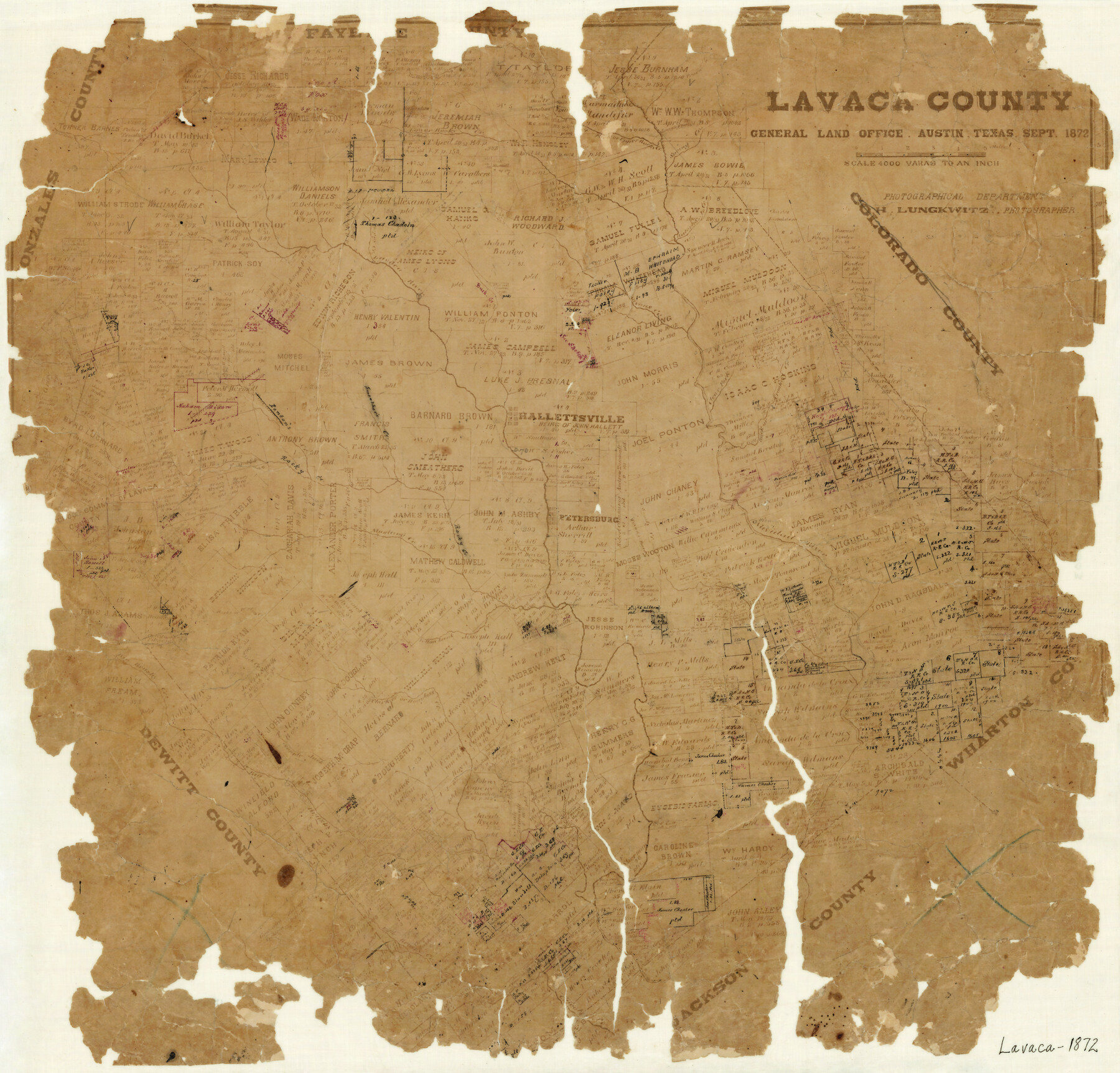
Lavaca County
-
Map/Doc
3803
-
Collection
General Map Collection
-
Object Dates
9/1872 (Creation Date)
-
People and Organizations
Herman Lungkwitz (Draftsman)
-
Counties
Lavaca
-
Subjects
County
-
Height x Width
19.9 x 20.7 inches
50.6 x 52.6 cm
-
Features
Yellowbanck Creek
Navidad River
Willow Creek
Petersburg
Rocky Creek
Mustang Creek
Big Brushy Creek
Jack Creek
Clark's Creek
Douglass Creek
South Sandy Creek
Liverpool Creek
Little Brushy Creek
Scarborough Creek
Atascosita Road
Chicolete Creek
Indian Branch [of Rocky Creek]
Hardy's Creek
Silverwood Creek
Texana Road
Buck Creek
Mulberry Creek
Lower Rocky Creek
South Fork of Rocky Creek
Upper Rocky Creek
Prairie Creek
Spring Creek
Waterhole Creek
Gonzales Road
Mixons Creek
Branch of Peach Creek
Lavaca River
Boggy Creek
Ponton's Creek
Smeather's Creek
Hallettsville
Clear Fork of Navidad River
Crooked Creek
North Sandy Creek
East Sandy Creek
Part of: General Map Collection
[Surveys in the Victoria District along the Guadalupe and Coleto Rivers]
![21, [Surveys in the Victoria District along the Guadalupe and Coleto Rivers], General Map Collection](https://historictexasmaps.com/wmedia_w700/maps/21.tif.jpg)
Print $20.00
- Digital $50.00
[Surveys in the Victoria District along the Guadalupe and Coleto Rivers]
1840
Size 26.0 x 19.6 inches
Map/Doc 21
Bastrop County Sketch File 9

Print $40.00
- Digital $50.00
Bastrop County Sketch File 9
1943
Size 46.5 x 20.6 inches
Map/Doc 10320
Tom Green Co.

Print $40.00
- Digital $50.00
Tom Green Co.
1887
Size 43.9 x 111.7 inches
Map/Doc 82063
Newton County Sketch File 13

Print $22.00
- Digital $50.00
Newton County Sketch File 13
Size 8.1 x 12.7 inches
Map/Doc 32386
Bee County Working Sketch 22

Print $20.00
- Digital $50.00
Bee County Working Sketch 22
1983
Size 37.9 x 37.2 inches
Map/Doc 67272
Hall County Working Sketch 4

Print $20.00
- Digital $50.00
Hall County Working Sketch 4
1923
Size 29.0 x 19.7 inches
Map/Doc 63332
Childress County Rolled Sketch 9B

Print $20.00
- Digital $50.00
Childress County Rolled Sketch 9B
Size 17.3 x 23.6 inches
Map/Doc 5448
Howard County Working Sketch 2

Print $20.00
- Digital $50.00
Howard County Working Sketch 2
1903
Size 21.7 x 20.9 inches
Map/Doc 66268

Pecos County Rolled Sketch 143

Print $74.00
- Digital $50.00
Pecos County Rolled Sketch 143
1935
Size 14.8 x 9.4 inches
Map/Doc 48359
Hartley County Boundary File 1

Print $64.00
- Digital $50.00
Hartley County Boundary File 1
Size 8.8 x 25.8 inches
Map/Doc 54423
Uvalde County Boundary File 2

Print $5.00
- Digital $50.00
Uvalde County Boundary File 2
Size 13.1 x 9.5 inches
Map/Doc 59556
You may also like
Kent County Working Sketch 10

Print $20.00
- Digital $50.00
Kent County Working Sketch 10
Size 34.1 x 43.0 inches
Map/Doc 70017
Map of Leon County

Print $40.00
- Digital $50.00
Map of Leon County
1916
Size 49.3 x 42.5 inches
Map/Doc 66901
General Highway Map, Tyler County, Texas

Print $20.00
General Highway Map, Tyler County, Texas
1940
Size 24.8 x 18.1 inches
Map/Doc 79264
Lipscomb County Boundary File 14

Print $62.00
- Digital $50.00
Lipscomb County Boundary File 14
Size 13.3 x 8.8 inches
Map/Doc 56355
[Surveys along the Frio River at the confluence of the Sabinal River]
![78372, [Surveys along the Frio River at the confluence of the Sabinal River], General Map Collection](https://historictexasmaps.com/wmedia_w700/maps/78372.tif.jpg)
Print $2.00
- Digital $50.00
[Surveys along the Frio River at the confluence of the Sabinal River]
1845
Size 6.2 x 8.9 inches
Map/Doc 78372
Zavala County Rolled Sketch 16

Print $20.00
- Digital $50.00
Zavala County Rolled Sketch 16
Size 19.4 x 25.4 inches
Map/Doc 8321
[Mary L. Williams or Lydia Glasgow Survey, Bastrop County, Texas]
![572, [Mary L. Williams or Lydia Glasgow Survey, Bastrop County, Texas], Maddox Collection](https://historictexasmaps.com/wmedia_w700/maps/0572-1.tif.jpg)
Print $3.00
- Digital $50.00
[Mary L. Williams or Lydia Glasgow Survey, Bastrop County, Texas]
Size 11.9 x 15.6 inches
Map/Doc 572
Liberty County Working Sketch 49b

Print $20.00
- Digital $50.00
Liberty County Working Sketch 49b
1955
Size 28.0 x 31.0 inches
Map/Doc 70509
El Paso County Sketch File 13

Print $8.00
- Digital $50.00
El Paso County Sketch File 13
1905
Size 7.4 x 6.8 inches
Map/Doc 22005
Motley County Sketch File 2-D

Print $40.00
- Digital $50.00
Motley County Sketch File 2-D
1903
Size 16.3 x 24.7 inches
Map/Doc 42134
Hansford County Working Sketch 7

Print $20.00
- Digital $50.00
Hansford County Working Sketch 7
1969
Size 27.7 x 23.9 inches
Map/Doc 63379
[Map Showing Surveys in Dimmit & La Salle Counties, Texas]
![75791, [Map Showing Surveys in Dimmit & La Salle Counties, Texas], Maddox Collection](https://historictexasmaps.com/wmedia_w700/maps/75791.tif.jpg)
Print $20.00
- Digital $50.00
[Map Showing Surveys in Dimmit & La Salle Counties, Texas]
Size 29.5 x 29.5 inches
Map/Doc 75791