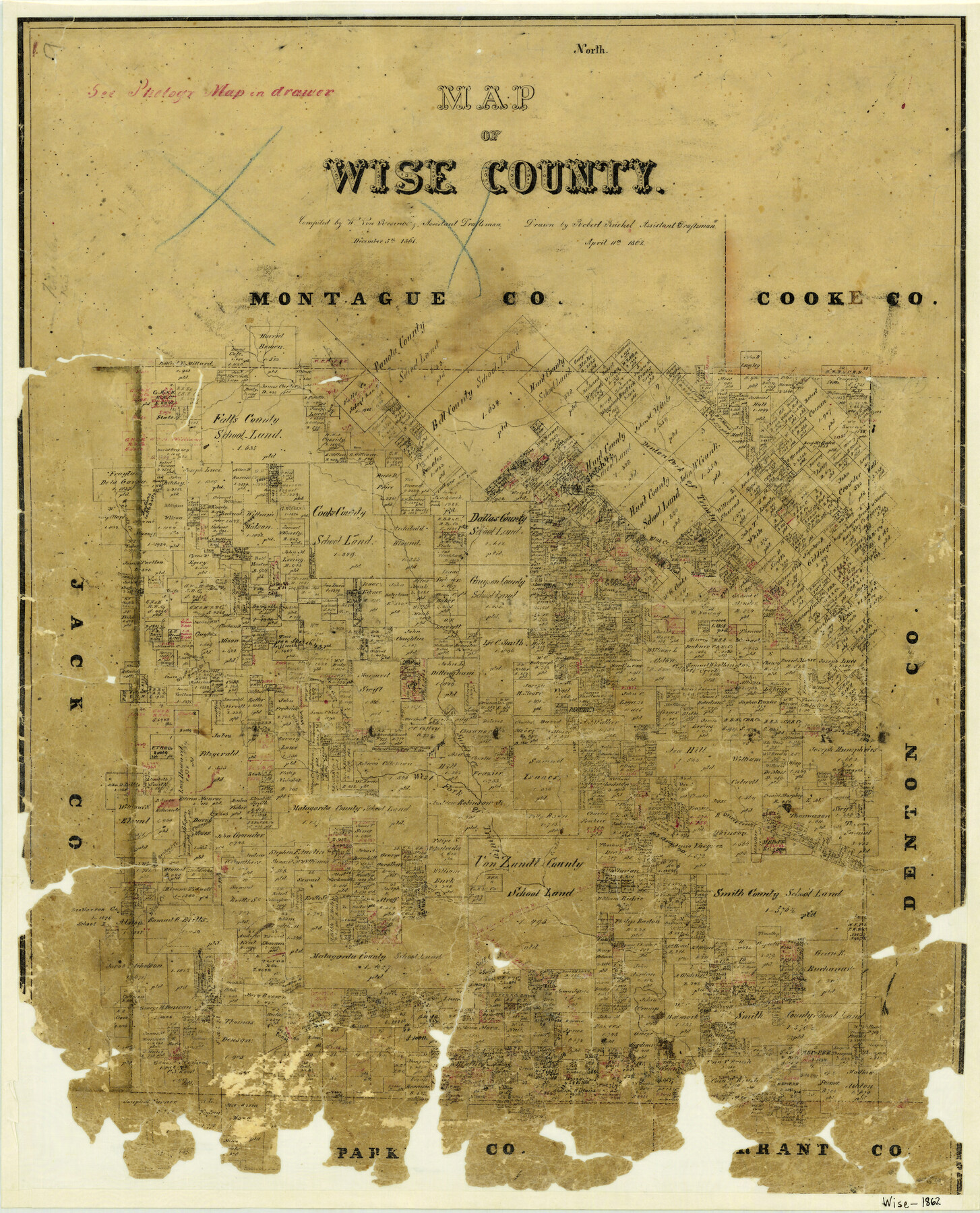
Map of Wise County
-
Map/Doc
4162
-
Collection
General Map Collection
-
Object Dates
1862 (Creation Date)
-
People and Organizations
Texas General Land Office (Publisher)
Robert Reichel (Draftsman)
W. von Rosenberg (Compiler)
-
Counties
Wise
-
Subjects
County
-
Height x Width
23.5 x 19.0 inches
59.7 x 48.3 cm
-
Comments
Compiled December 5, 1861; drawn April 11, 1862.
-
Features
Village Creek
Cottonwood Branch [of Salt Creek]
Hearst Creek
Turkey Creek
Salt Creek
Willow Creek
Boggy Creek
M&P
Oliver Creek
Center Creek
Thompson's Creek
Gentry's Creek
Denton Fork of Trinity [River]
West Fork of Trinity River
Sandy Creek
Cattlet's [sic] Creek
Decatur
Bean's Creek
Mountain Creek
Martin's Creek
Blak [sic] Creek
Bennet's [sic] Creek
Brushy Creek
Part of: General Map Collection
Garza County Rolled Sketch 17

Print $20.00
- Digital $50.00
Garza County Rolled Sketch 17
1959
Size 32.3 x 37.6 inches
Map/Doc 6003
Jeff Davis County Sketch File 34

Print $16.00
- Digital $50.00
Jeff Davis County Sketch File 34
1915
Size 8.5 x 5.4 inches
Map/Doc 28040
Map of subdivision of submerged land in the Gulf of Mexico fronting on Matagorda Island and Peninsula

Print $40.00
- Digital $50.00
Map of subdivision of submerged land in the Gulf of Mexico fronting on Matagorda Island and Peninsula
1940
Size 28.2 x 61.3 inches
Map/Doc 2929
Carson County Working Sketch 5

Print $20.00
- Digital $50.00
Carson County Working Sketch 5
1979
Size 42.2 x 14.5 inches
Map/Doc 67876
Menard County Working Sketch 6

Print $20.00
- Digital $50.00
Menard County Working Sketch 6
1924
Size 24.4 x 15.3 inches
Map/Doc 70953
Nolan County Sketch File 2

Print $40.00
- Digital $50.00
Nolan County Sketch File 2
Size 49.5 x 41.6 inches
Map/Doc 10556
Upton County Rolled Sketch 15

Print $20.00
- Digital $50.00
Upton County Rolled Sketch 15
1927
Size 25.0 x 19.2 inches
Map/Doc 8070
Potter County

Print $20.00
- Digital $50.00
Potter County
1960
Size 42.6 x 34.6 inches
Map/Doc 66985
Wichita County Sketch File 9a

Print $4.00
- Digital $50.00
Wichita County Sketch File 9a
Size 10.7 x 8.2 inches
Map/Doc 40052
Newton County Aerial Photograph Index Sheet 1

Print $20.00
- Digital $50.00
Newton County Aerial Photograph Index Sheet 1
1953
Size 23.8 x 18.7 inches
Map/Doc 83730
Hamilton County Working Sketch 13

Print $40.00
- Digital $50.00
Hamilton County Working Sketch 13
1949
Size 43.5 x 57.0 inches
Map/Doc 63351
Edwards County Working Sketch 17

Print $20.00
- Digital $50.00
Edwards County Working Sketch 17
1930
Size 32.3 x 26.8 inches
Map/Doc 68893
You may also like
Gaines County Working Sketch 23

Print $20.00
- Digital $50.00
Gaines County Working Sketch 23
1982
Size 29.1 x 41.8 inches
Map/Doc 69323
Young County Sketch File 14

Print $20.00
- Digital $50.00
Young County Sketch File 14
1895
Size 10.9 x 27.3 inches
Map/Doc 12712
Angelina County Sketch File 18c

Print $4.00
- Digital $50.00
Angelina County Sketch File 18c
Size 12.8 x 8.3 inches
Map/Doc 13034
[Surveys in the Jefferson District along Big Sandy Creek]
![100, [Surveys in the Jefferson District along Big Sandy Creek], General Map Collection](https://historictexasmaps.com/wmedia_w700/maps/100.tif.jpg)
Print $2.00
- Digital $50.00
[Surveys in the Jefferson District along Big Sandy Creek]
1841
Size 9.5 x 8.1 inches
Map/Doc 100
Sutton County Working Sketch 43

Print $20.00
- Digital $50.00
Sutton County Working Sketch 43
1951
Size 23.1 x 22.1 inches
Map/Doc 62386
Flight Mission No. DCL-7C, Frame 45, Kenedy County

Print $20.00
- Digital $50.00
Flight Mission No. DCL-7C, Frame 45, Kenedy County
1943
Size 15.4 x 15.3 inches
Map/Doc 86033
Pecos County Working Sketch 129

Print $20.00
- Digital $50.00
Pecos County Working Sketch 129
1976
Map/Doc 71603
Lipscomb County Working Sketch Graphic Index

Print $20.00
- Digital $50.00
Lipscomb County Working Sketch Graphic Index
1899
Size 41.4 x 38.4 inches
Map/Doc 76622
Kent County Rolled Sketch 5

Print $20.00
- Digital $50.00
Kent County Rolled Sketch 5
1951
Size 43.7 x 36.9 inches
Map/Doc 78522
Motley County Working Sketch 6

Print $20.00
- Digital $50.00
Motley County Working Sketch 6
1963
Size 17.6 x 29.3 inches
Map/Doc 71211
Buenaventura Reyes Grants

Print $20.00
- Digital $50.00
Buenaventura Reyes Grants
1896
Size 14.9 x 13.5 inches
Map/Doc 2057
Rio Grande, Donna Sheet

Print $20.00
- Digital $50.00
Rio Grande, Donna Sheet
1937
Size 37.5 x 37.4 inches
Map/Doc 65117