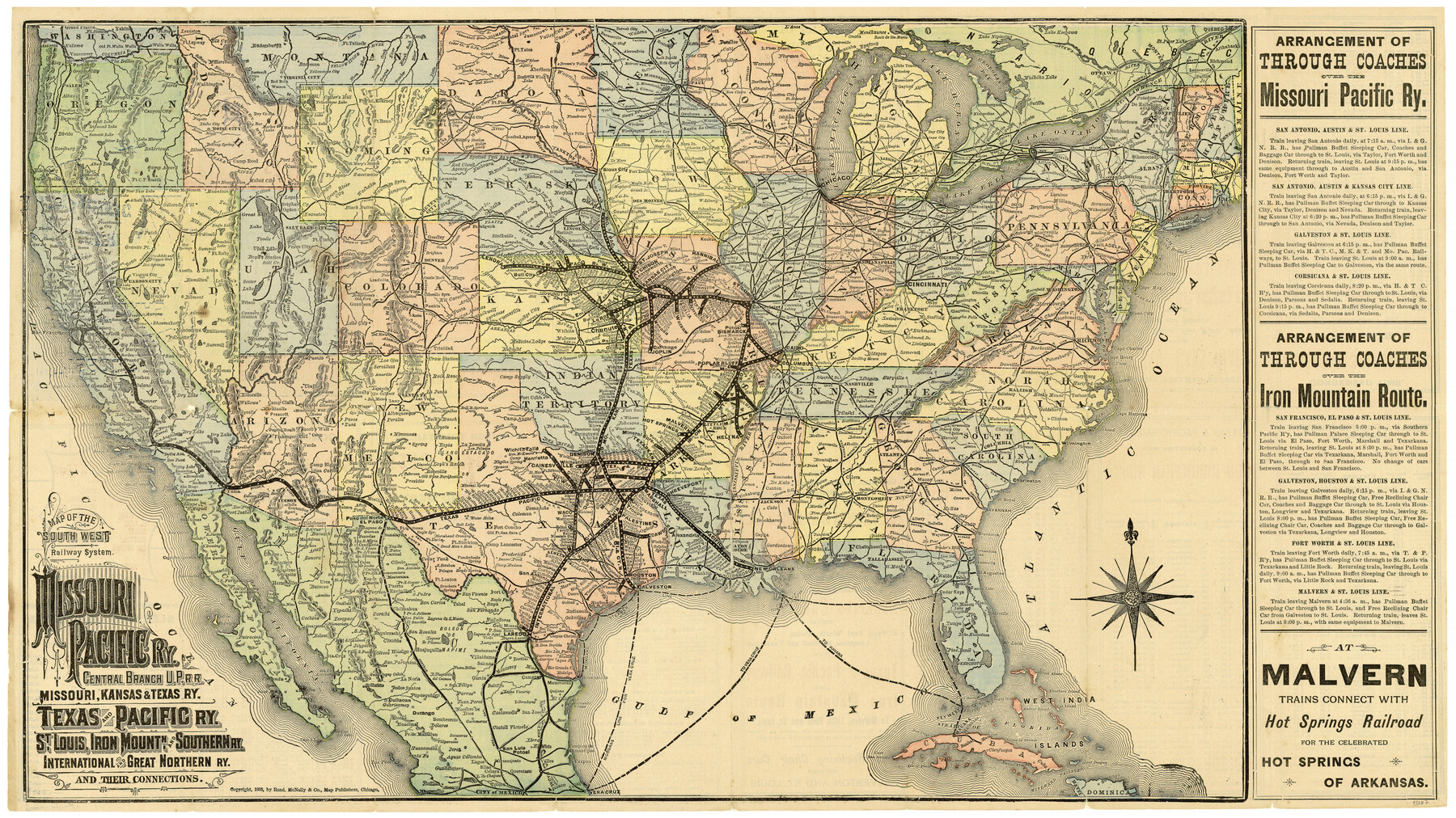
Map of the Southwest Railway System
Missouri Pacific Ry, Central Branch U. P. RR, Missouri, Kansas and Texas Ry., Texas and Pacific Ry., St. Louis, Iron Mountn and Southern Ry., International and Great Northern Ry. and their connections
-
Map/Doc
93287
-
Collection
General Map Collection
-
Object Dates
1883 (Creation Date)
4/25/2012 (File Date)
-
People and Organizations
Rand McNally and Company (Publisher)
-
Subjects
Railroads United States
-
Height x Width
16.0 x 28.8 inches
40.6 x 73.2 cm
-
Comments
To view/download timetables on verso, please click the "Download PDF" link above.
Conservation funded in 2012. -
URLs
https://medium.com/save-texas-history/map-of-the-southwest-railway-system-1883-808505b255ba#.c0tf1yn5z
Part of: General Map Collection
Harrison County

Print $20.00
- Digital $50.00
Harrison County
1857
Size 20.3 x 21.0 inches
Map/Doc 1116
Henderson County Working Sketch 8

Print $20.00
- Digital $50.00
Henderson County Working Sketch 8
1922
Size 15.9 x 16.1 inches
Map/Doc 66141
Tyler County Sketch File 17a

Print $4.00
- Digital $50.00
Tyler County Sketch File 17a
1853
Size 6.6 x 8.0 inches
Map/Doc 38664
Trinity River, OwenCrossing Sheet/Elm Fork of Trinity River

Print $20.00
- Digital $50.00
Trinity River, OwenCrossing Sheet/Elm Fork of Trinity River
1914
Size 29.2 x 29.4 inches
Map/Doc 78340
Nueces River, Corpus Christi Sheet No. 1-A

Print $6.00
- Digital $50.00
Nueces River, Corpus Christi Sheet No. 1-A
1938
Size 21.9 x 33.2 inches
Map/Doc 65090
Presidio County Rolled Sketch 144

Print $20.00
- Digital $50.00
Presidio County Rolled Sketch 144
2010
Size 36.0 x 24.0 inches
Map/Doc 89602
Irion County Rolled Sketch 22

Print $20.00
- Digital $50.00
Irion County Rolled Sketch 22
1936
Size 24.3 x 39.9 inches
Map/Doc 6330
Sketches of Surveys in Jefferson County

Print $2.00
- Digital $50.00
Sketches of Surveys in Jefferson County
1841
Size 7.5 x 7.0 inches
Map/Doc 326
Val Verde County Rolled Sketch 36

Print $40.00
- Digital $50.00
Val Verde County Rolled Sketch 36
Size 49.6 x 43.7 inches
Map/Doc 10072
Angelina County Sketch File 29

Print $4.00
- Digital $50.00
Angelina County Sketch File 29
1911
Size 8.0 x 8.4 inches
Map/Doc 13087
Brewster County Working Sketch 15

Print $20.00
- Digital $50.00
Brewster County Working Sketch 15
1929
Size 30.4 x 40.9 inches
Map/Doc 67548
Foard County Rolled Sketch 14

Print $20.00
- Digital $50.00
Foard County Rolled Sketch 14
1923
Size 20.2 x 36.0 inches
Map/Doc 5888
You may also like
Culberson County Rolled Sketch 62

Print $20.00
- Digital $50.00
Culberson County Rolled Sketch 62
1985
Size 20.8 x 20.5 inches
Map/Doc 5678
Navasota and Grimes County, Texas

Navasota and Grimes County, Texas
Size 25.8 x 28.5 inches
Map/Doc 96865
The Compass Rose of Austin's Colony

Price $20.00
The Compass Rose of Austin's Colony
2016
Size 4.0 x 3.5 inches
Map/Doc 94443
Photo Index of Texas Coast - Sheet 4 of 6

Print $20.00
- Digital $50.00
Photo Index of Texas Coast - Sheet 4 of 6
1954
Size 20.0 x 24.0 inches
Map/Doc 83442
Map of Tarrant County

Print $20.00
- Digital $50.00
Map of Tarrant County
1867
Size 30.0 x 19.3 inches
Map/Doc 4066
Mason County Sketch File 4

Print $6.00
- Digital $50.00
Mason County Sketch File 4
1875
Size 12.9 x 8.0 inches
Map/Doc 30684

Hardeman County Sketch File A3

Print $4.00
- Digital $50.00
Hardeman County Sketch File A3
1890
Size 14.2 x 8.8 inches
Map/Doc 25052
Sutton County Rolled Sketch 66

Print $20.00
- Digital $50.00
Sutton County Rolled Sketch 66
Size 25.3 x 25.1 inches
Map/Doc 7901
Brewster County Rolled Sketch 24C

Print $20.00
- Digital $50.00
Brewster County Rolled Sketch 24C
Size 17.5 x 20.8 inches
Map/Doc 5210
Duval County Working Sketch 12

Print $20.00
- Digital $50.00
Duval County Working Sketch 12
1937
Size 22.1 x 27.8 inches
Map/Doc 68725
General Highway Map, Gray County, Texas

Print $20.00
General Highway Map, Gray County, Texas
1940
Size 25.0 x 18.4 inches
Map/Doc 79103