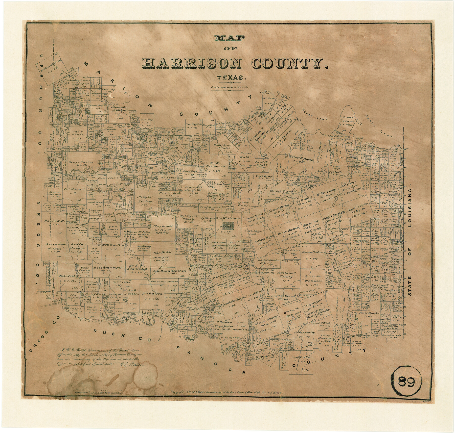
Map of Harrison County, Texas
-
Map/Doc
375
-
Collection
Maddox Collection
-
Object Dates
1879 (Creation Date)
-
People and Organizations
W.C. Walsh (GLO Commissioner)
F.G. Blau (Draftsman)
August Gast & Co. (Lithographer)
-
Counties
Harrison
-
Subjects
County
-
Height x Width
20.2 x 21.9 inches
51.3 x 55.6 cm
-
Medium
paper, etching/engraving/lithograph
-
Scale
1" = 4000 varas
-
Comments
Conservation funded in 2007 by Friends of the Texas General Land Office.
-
Features
Ferry Lake
Big Cypress Creek
Little Cypress Creek
Caddo Lake
Haggertys Creek
Morriss Creek
Rays Creek
Village Creek
Marshall
Masons Creek
Dufford's Creek
Potters Creek
Eight Miles Creek
Cane Creek
Caddo Creek
Sabine River
Part of: Maddox Collection
Part of original sketch of Block "H" W. & N. W. Ry. Co. Cottle County

Print $20.00
- Digital $50.00
Part of original sketch of Block "H" W. & N. W. Ry. Co. Cottle County
Size 13.7 x 14.6 inches
Map/Doc 10776
Map showing lands of D. Sullivan situated in Starr County, Texas

Print $20.00
- Digital $50.00
Map showing lands of D. Sullivan situated in Starr County, Texas
Size 15.5 x 18.6 inches
Map/Doc 755
Bastrop County

Print $20.00
- Digital $50.00
Bastrop County
1879
Size 27.1 x 26.1 inches
Map/Doc 692
[Surveying Sketch of Jesse McGee, Jas McKim, W. S. Kennard, et al in Sabine and Newton Counties, Texas]
![5066, [Surveying Sketch of Jesse McGee, Jas McKim, W. S. Kennard, et al in Sabine and Newton Counties, Texas], Maddox Collection](https://historictexasmaps.com/wmedia_w700/maps/5066.tif.jpg)
Print $20.00
- Digital $50.00
[Surveying Sketch of Jesse McGee, Jas McKim, W. S. Kennard, et al in Sabine and Newton Counties, Texas]
1916
Size 32.0 x 37.5 inches
Map/Doc 5066
Schleicher County

Print $20.00
- Digital $50.00
Schleicher County
1898
Size 23.1 x 36.3 inches
Map/Doc 615
Map Representing the Original Locations of Various Surveys Deliniated Thereon

Print $40.00
- Digital $50.00
Map Representing the Original Locations of Various Surveys Deliniated Thereon
1890
Size 40.8 x 62.0 inches
Map/Doc 469
Refugio County, Texas

Print $20.00
- Digital $50.00
Refugio County, Texas
1879
Size 19.9 x 29.0 inches
Map/Doc 600
Sketch showing connections made in survey of the Jerry Barton preemption

Print $20.00
- Digital $50.00
Sketch showing connections made in survey of the Jerry Barton preemption
1892
Size 18.5 x 23.6 inches
Map/Doc 75558
[Dennis Corwin's Map of Survey for R. N. Graham]
![83427, [Dennis Corwin's Map of Survey for R. N. Graham], Maddox Collection](https://historictexasmaps.com/wmedia_w700/maps/83427.tif.jpg)
Print $2.00
- Digital $50.00
[Dennis Corwin's Map of Survey for R. N. Graham]
Size 11.1 x 8.5 inches
Map/Doc 83427
Map of Duval County, Texas

Print $20.00
- Digital $50.00
Map of Duval County, Texas
1880
Size 29.8 x 22.6 inches
Map/Doc 712
Survey 1, Block 1, D.B. Gardner in Dickens County

Print $20.00
- Digital $50.00
Survey 1, Block 1, D.B. Gardner in Dickens County
1914
Size 14.9 x 30.4 inches
Map/Doc 10767
Topography and water depth as shown by the U.S. Coast Survey of 1888

Print $20.00
- Digital $50.00
Topography and water depth as shown by the U.S. Coast Survey of 1888
1890
Size 17.0 x 18.8 inches
Map/Doc 390
You may also like
Current Miscellaneous File 6

Print $4.00
- Digital $50.00
Current Miscellaneous File 6
Size 11.3 x 8.8 inches
Map/Doc 73731
Milam County Sketch File 4

Print $4.00
- Digital $50.00
Milam County Sketch File 4
Size 7.6 x 8.2 inches
Map/Doc 31630
Galveston County Sketch File 6

Print $4.00
- Digital $50.00
Galveston County Sketch File 6
Size 14.2 x 8.9 inches
Map/Doc 23362
Lampasas County Boundary File 4

Print $44.00
- Digital $50.00
Lampasas County Boundary File 4
Size 14.0 x 8.5 inches
Map/Doc 56110
Hardin County Rolled Sketch 3

Print $20.00
- Digital $50.00
Hardin County Rolled Sketch 3
1902
Size 20.1 x 17.0 inches
Map/Doc 6076
FT. W. & R. G. Ry. Right of Way Map, Winchell to Brady, McCulloch County, Texas

Print $20.00
- Digital $50.00
FT. W. & R. G. Ry. Right of Way Map, Winchell to Brady, McCulloch County, Texas
1918
Size 36.9 x 32.0 inches
Map/Doc 61416
North America corrected from the observations communicated to the Royal Society at London and the Royal Academy at Paris

Print $20.00
- Digital $50.00
North America corrected from the observations communicated to the Royal Society at London and the Royal Academy at Paris
1710
Size 38.9 x 26.9 inches
Map/Doc 93820
Knox County Working Sketch 6

Print $20.00
- Digital $50.00
Knox County Working Sketch 6
1937
Size 31.4 x 18.2 inches
Map/Doc 70248
University Land Field Notes for Blocks 27 and 28 in Pecos County

University Land Field Notes for Blocks 27 and 28 in Pecos County
Map/Doc 81723
Cass County Sketch File 23

Print $10.00
- Digital $50.00
Cass County Sketch File 23
1936
Size 14.1 x 8.6 inches
Map/Doc 17435
Texas Gulf Coast Map from the Sabine River to the Rio Grande as subdivided for mineral development

Print $40.00
- Digital $50.00
Texas Gulf Coast Map from the Sabine River to the Rio Grande as subdivided for mineral development
1948
Size 49.3 x 55.7 inches
Map/Doc 2906
Flight Mission No. BRA-8M, Frame 126, Jefferson County

Print $20.00
- Digital $50.00
Flight Mission No. BRA-8M, Frame 126, Jefferson County
1953
Size 19.1 x 22.7 inches
Map/Doc 85622