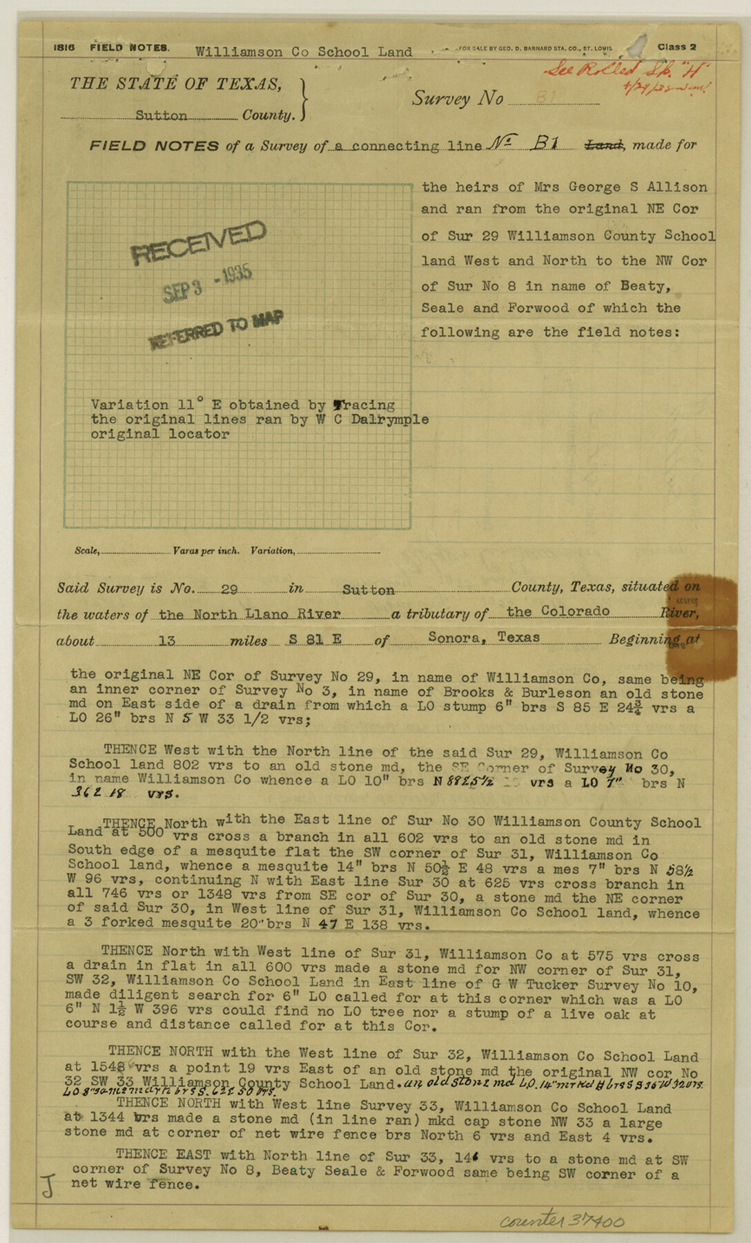
Sutton County Sketch File H
[Connecting line between northwest corner of section 85, Block B, H. E. & W. T. and southwest corner of section 9, Block D, G. C. & S. F.]
-
Map/Doc
37400
-
Collection
General Map Collection
-
Object Dates
1935 (File Date)
-
People and Organizations
John McNicol (Surveyor/Engineer)
James McLaughlin (Chainman/Field Personnel)
Alfred Schweining (Chainman/Field Personnel)
Edgar C. Saunders (Surveyor/Engineer)
Harold Saunders (Chainman/Field Personnel)
Alden Garrett (Chainman/Field Personnel)
Warren McDonald (Chainman/Field Personnel)
Anestceo Duran (Chainman/Field Personnel)
John Nix (Chainman/Field Personnel)
Fred Simmons (Chainman/Field Personnel)
Abe Acker (Chainman/Field Personnel)
Tom Adams (Chainman/Field Personnel)
J.L. Conn (Chainman/Field Personnel)
Arthur Simmons (Chainman/Field Personnel)
-
Counties
Sutton
-
Subjects
Surveying Sketch File
-
Height x Width
14.3 x 8.7 inches
36.3 x 22.1 cm
-
Medium
paper, print
-
Comments
See Sutton County Rolled Sketch H (9973) for sketch.
-
Features
North Llano River
Colorado River
Sonora
Rio Grande
Fort Terrett
Related maps
Sutton County Rolled Sketch H

Print $40.00
- Digital $50.00
Sutton County Rolled Sketch H
Size 24.9 x 50.0 inches
Map/Doc 9973
Part of: General Map Collection
Washington County Working Sketch 1

Print $20.00
- Digital $50.00
Washington County Working Sketch 1
1957
Size 25.1 x 25.4 inches
Map/Doc 72362
Cass County Sketch File 24

Print $16.00
- Digital $50.00
Cass County Sketch File 24
1936
Size 13.9 x 8.7 inches
Map/Doc 17436
Flight Mission No. BQY-4M, Frame 58, Harris County

Print $20.00
- Digital $50.00
Flight Mission No. BQY-4M, Frame 58, Harris County
1953
Size 18.5 x 22.3 inches
Map/Doc 85267
Matagorda County Sketch File 32

Print $20.00
- Digital $50.00
Matagorda County Sketch File 32
1918
Size 36.5 x 30.4 inches
Map/Doc 10531
Coke County Working Sketch 20

Print $20.00
- Digital $50.00
Coke County Working Sketch 20
1949
Size 47.8 x 43.1 inches
Map/Doc 68057
Kimble County Sketch File B

Print $22.00
- Digital $50.00
Kimble County Sketch File B
Size 14.3 x 12.7 inches
Map/Doc 28963
Runnels County Rolled Sketch 40

Print $20.00
- Digital $50.00
Runnels County Rolled Sketch 40
Size 33.5 x 40.9 inches
Map/Doc 7527
Topographic and Road Map, Travis County

Print $40.00
- Digital $50.00
Topographic and Road Map, Travis County
1932
Size 37.5 x 48.2 inches
Map/Doc 4673
Jefferson County Rolled Sketch 57

Print $20.00
- Digital $50.00
Jefferson County Rolled Sketch 57
1874
Size 25.9 x 18.6 inches
Map/Doc 6408
Presidio County Working Sketch 92

Print $20.00
- Digital $50.00
Presidio County Working Sketch 92
1976
Size 27.1 x 23.1 inches
Map/Doc 71769
Culberson County Rolled Sketch 47

Print $20.00
- Digital $50.00
Culberson County Rolled Sketch 47
1959
Size 35.1 x 31.5 inches
Map/Doc 8755

You may also like
Plan of the Battle of Buena-Vista fought February 22nd and 23rd, 1847

Print $20.00
- Digital $50.00
Plan of the Battle of Buena-Vista fought February 22nd and 23rd, 1847
1847
Size 17.8 x 21.5 inches
Map/Doc 94112
Sabine County Sketch File 11

Print $4.00
Sabine County Sketch File 11
Size 6.2 x 8.3 inches
Map/Doc 35629
Panola County Working Sketch 4

Print $20.00
- Digital $50.00
Panola County Working Sketch 4
1938
Map/Doc 71413
G.C. & S.F. Ry. Alinement and Right of Way map of Dallas Branch, Ellis County, Texas

Print $20.00
- Digital $50.00
G.C. & S.F. Ry. Alinement and Right of Way map of Dallas Branch, Ellis County, Texas
1925
Size 30.9 x 44.2 inches
Map/Doc 64548
Map of Bexar County

Print $40.00
- Digital $50.00
Map of Bexar County
1887
Size 46.1 x 48.6 inches
Map/Doc 16942
[Drawings of individual counties for Pressler and Langermann's 1879 Map of Texas]
![[Drawings of individual counties for Pressler and Langermann's 1879 Map of Texas]](https://historictexasmaps.com/wmedia_w700/maps/4863.tif.jpg)
Print $20.00
- Digital $50.00
[Drawings of individual counties for Pressler and Langermann's 1879 Map of Texas]
1878
Size 38.8 x 26.8 inches
Map/Doc 4863
Fayette County

Print $40.00
- Digital $50.00
Fayette County
1920
Size 42.7 x 49.8 inches
Map/Doc 4945
Erath County Sketch File A2

Print $20.00
- Digital $50.00
Erath County Sketch File A2
Size 15.9 x 19.5 inches
Map/Doc 11464
Harris County Working Sketch 20

Print $20.00
- Digital $50.00
Harris County Working Sketch 20
1923
Size 11.7 x 12.4 inches
Map/Doc 65912
Map of Leon County

Print $40.00
- Digital $50.00
Map of Leon County
1916
Size 48.4 x 40.8 inches
Map/Doc 16877
Milam County Working Sketch 9

Print $20.00
- Digital $50.00
Milam County Working Sketch 9
1976
Size 27.2 x 22.7 inches
Map/Doc 71024
The Judicial District/County of Smith. Abolished, Spring 1842

Print $20.00
The Judicial District/County of Smith. Abolished, Spring 1842
2020
Size 19.6 x 21.7 inches
Map/Doc 96347