Gaines County Sketch File 7
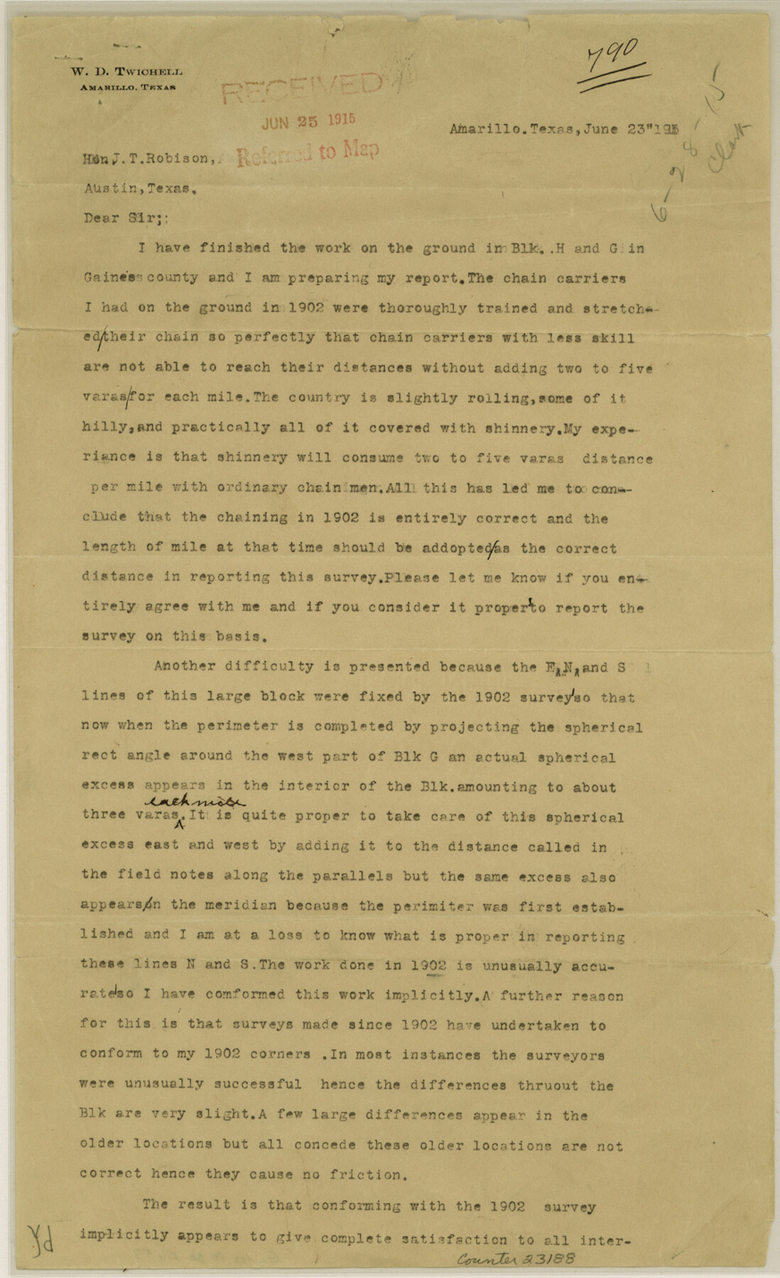
[Letter from Twichell stating that he had finished ground work in Blocks H and G]
- 
                          Map/Doc
23188
 - 
                            Collection
General Map Collection
 - 
                            Object Dates
1915/6/23 (Creation Date)
1915/6/25 (File Date)
1902 (Survey Date)
 - 
                            People and Organizations
W.D. Twichell (Surveyor/Engineer)
 - 
                            Counties
Gaines
 - 
                            Subjects
Surveying Sketch File
 - 
                            Height x Width
14.3 x 8.7 inches
36.3 x 22.1 cm
 - 
                            Medium
paper, print
 
Part of: General Map Collection
            Marion County


                                            Print $20.00                    
                                             -                         Digital $50.00                                    
                Marion County
1943
Size 30.3 x 47.9 inches
                                Map/Doc 95579
            
            Montague County


                                            Print $20.00                    
                                             -                         Digital $50.00                                    
                Montague County
1924
Size 46.9 x 33.7 inches
                                Map/Doc 73243
            
            San Patricio County Rolled Sketch 46B


                                            Print $3.00                    
                                             -                         Digital $50.00                                    
                San Patricio County Rolled Sketch 46B
1983
Size 12.5 x 10.0 inches
                                Map/Doc 8373
            
            Henderson County Sketch File 1


                                            Print $8.00                    
                                             -                         Digital $50.00                                    
                Henderson County Sketch File 1
Size 12.8 x 8.3 inches
                                Map/Doc 26318
            
            Trinity River, Levee Improvement Districts, Widths of Floodways/Pilot Grove Creek and East Fork Trinity River


                                            Print $6.00                    
                                             -                         Digital $50.00                                    
                Trinity River, Levee Improvement Districts, Widths of Floodways/Pilot Grove Creek and East Fork Trinity River
1920
Size 33.0 x 17.1 inches
                                Map/Doc 65259
            
            Starr County Working Sketch 30


                                            Print $20.00                    
                                             -                         Digital $50.00                                    
                Starr County Working Sketch 30
2015
Size 24.6 x 36.6 inches
                                Map/Doc 93750
            
            Erath County Working Sketch 51


                                            Print $20.00                    
                                             -                         Digital $50.00                                    
                Erath County Working Sketch 51
1986
Size 38.3 x 45.6 inches
                                Map/Doc 69133
            
            Copy of Surveyor's Field Book, Morris Browning - In Blocks 7, 5 & 4, I&GNRRCo., Hutchinson and Carson Counties, Texas


                                            Print $2.00                    
                                             -                         Digital $50.00                                    
                Copy of Surveyor's Field Book, Morris Browning - In Blocks 7, 5 & 4, I&GNRRCo., Hutchinson and Carson Counties, Texas
1888
Size 7.0 x 8.8 inches
                                Map/Doc 62270
            
            Cameron County Rolled Sketch 28


                                            Print $40.00                    
                                             -                         Digital $50.00                                    
                Cameron County Rolled Sketch 28
1986
Size 36.5 x 48.3 inches
                                Map/Doc 8575
            
            Atlantic Coast to the Rocky Mountains


            Atlantic Coast to the Rocky Mountains
1956
Size 42.3 x 29.5 inches
                                Map/Doc 94410
            
            Pecos County Sketch File 40


                                            Print $30.00                    
                                             -                         Digital $50.00                                    
                Pecos County Sketch File 40
1919
Size 14.6 x 9.2 inches
                                Map/Doc 33722
            
            Smith County Rolled Sketch 6A3


                                            Print $40.00                    
                                             -                         Digital $50.00                                    
                Smith County Rolled Sketch 6A3
1990
Size 48.6 x 36.8 inches
                                Map/Doc 10698
            You may also like
            Jackson County Aerial Photograph Index Sheet 7


                                            Print $20.00                    
                                             -                         Digital $50.00                                    
                Jackson County Aerial Photograph Index Sheet 7
1956
Size 21.2 x 15.8 inches
                                Map/Doc 83706
            
            General Highway Map, Kerr County, Texas


                                            Print $20.00                    
                                    
                General Highway Map, Kerr County, Texas
1940
Size 25.0 x 18.4 inches
                                Map/Doc 79158
            
            Refugio County Aerial Photograph Index Sheet 5


                                            Print $20.00                    
                                             -                         Digital $50.00                                    
                Refugio County Aerial Photograph Index Sheet 5
1957
Size 23.2 x 18.9 inches
                                Map/Doc 83743
            
            General Highway Map, Lavaca County, Texas


                                            Print $20.00                    
                                    
                General Highway Map, Lavaca County, Texas
1940
Size 24.7 x 18.3 inches
                                Map/Doc 79170
            
            Orange County Working Sketch 39


                                            Print $20.00                    
                                             -                         Digital $50.00                                    
                Orange County Working Sketch 39
1966
Size 20.5 x 27.8 inches
                                Map/Doc 71371
            
            Map of Great Britain and Ireland engraved to illustrate Mitchell's school and family geography


                                            Print $20.00                    
                                             -                         Digital $50.00                                    
                Map of Great Britain and Ireland engraved to illustrate Mitchell's school and family geography
1840
Size 11.8 x 9.5 inches
                                Map/Doc 93503
            
            Schleicher County Rolled Sketch 19


                                            Print $20.00                    
                                             -                         Digital $50.00                                    
                Schleicher County Rolled Sketch 19
Size 25.0 x 21.9 inches
                                Map/Doc 7761
            
            Calhoun County Rolled Sketch 17


                                            Print $20.00                    
                                             -                         Digital $50.00                                    
                Calhoun County Rolled Sketch 17
1957
Size 24.6 x 30.0 inches
                                Map/Doc 5370
            
            Jack County Sketch File 34


                                            Print $20.00                    
                                             -                         Digital $50.00                                    
                Jack County Sketch File 34
1951
Size 21.2 x 29.3 inches
                                Map/Doc 11832
            
            Blucher's Directory Map of Corpus Christi and Road Map of Nueces County


                                            Print $20.00                    
                                             -                         Digital $50.00                                    
                Blucher's Directory Map of Corpus Christi and Road Map of Nueces County
1945
Size 22.7 x 34.4 inches
                                Map/Doc 94105
            
            Harris County Working Sketch 39


                                            Print $20.00                    
                                             -                         Digital $50.00                                    
                Harris County Working Sketch 39
1940
Size 21.6 x 20.1 inches
                                Map/Doc 65931