Starr County Sketch File 31B
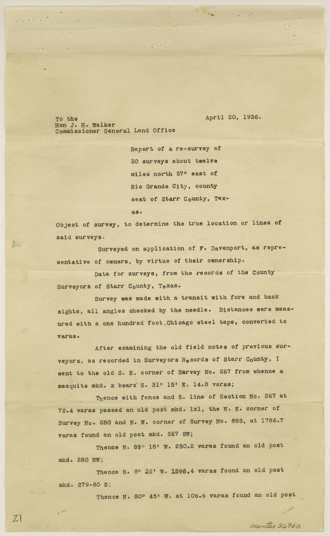
[Report of a resurvey of 30 surveys northeast from Rio Grande City]
-
Map/Doc
36960
-
Collection
General Map Collection
-
Object Dates
4/20/1936 (Creation Date)
4/30/1936 (File Date)
-
People and Organizations
J.H. May (Surveyor/Engineer)
-
Counties
Starr
-
Subjects
Surveying Sketch File
-
Height x Width
14.2 x 8.8 inches
36.1 x 22.4 cm
-
Medium
paper, print
-
Comments
See Starr County Sketch File 31A (12335) for sketch.
-
Features
Old Brownsville Telegraph Road
Related maps
Starr County Sketch File 31A

Print $20.00
- Digital $50.00
Starr County Sketch File 31A
1936
Size 24.5 x 13.3 inches
Map/Doc 12335
Part of: General Map Collection

Shelby County Working Sketch 35

Print $20.00
- Digital $50.00
Shelby County Working Sketch 35
2010
Size 27.4 x 28.3 inches
Map/Doc 89285
Duval County Boundary File 3g

Print $4.00
- Digital $50.00
Duval County Boundary File 3g
Size 9.9 x 7.8 inches
Map/Doc 52747
Texas Pacific Land Trust, Preliminary Plat Blocks 64-65-66 Tsp. 7 & 8 T&P RR Co. Surveys

Print $40.00
- Digital $50.00
Texas Pacific Land Trust, Preliminary Plat Blocks 64-65-66 Tsp. 7 & 8 T&P RR Co. Surveys
1962
Size 54.6 x 43.0 inches
Map/Doc 87210
Falls County Sketch File 11

Print $13.00
- Digital $50.00
Falls County Sketch File 11
1859
Size 12.6 x 9.8 inches
Map/Doc 22352
Flight Mission No. BRE-1P, Frame 49, Nueces County

Print $20.00
- Digital $50.00
Flight Mission No. BRE-1P, Frame 49, Nueces County
1956
Size 18.4 x 22.2 inches
Map/Doc 86638
Flight Mission No. BRE-2P, Frame 25, Nueces County

Print $20.00
- Digital $50.00
Flight Mission No. BRE-2P, Frame 25, Nueces County
1956
Size 18.4 x 22.2 inches
Map/Doc 86734
Orange County Working Sketch Graphic Index - sheet A

Print $20.00
- Digital $50.00
Orange County Working Sketch Graphic Index - sheet A
1921
Size 24.4 x 29.3 inches
Map/Doc 76658
Wichita County Sketch File 29

Print $9.00
- Digital $50.00
Wichita County Sketch File 29
1930
Size 11.3 x 8.8 inches
Map/Doc 40132
Brown County Working Sketch 2

Print $20.00
- Digital $50.00
Brown County Working Sketch 2
1919
Size 17.0 x 17.5 inches
Map/Doc 67767
Terrell County Working Sketch 19

Print $20.00
- Digital $50.00
Terrell County Working Sketch 19
1932
Size 18.8 x 25.7 inches
Map/Doc 62169
Gulf of Mexico

Print $20.00
- Digital $50.00
Gulf of Mexico
1908
Size 18.4 x 27.9 inches
Map/Doc 72662
You may also like
Topographical Map of the Rio Grande, Sheet No. 20

Print $20.00
- Digital $50.00
Topographical Map of the Rio Grande, Sheet No. 20
1912
Map/Doc 89544
Three-Way Consolidated County Line Independent School District, Bailey and Cochran Counties, Texas

Print $20.00
- Digital $50.00
Three-Way Consolidated County Line Independent School District, Bailey and Cochran Counties, Texas
Size 34.2 x 26.8 inches
Map/Doc 92527
Smith County Sketch File 5

Print $6.00
- Digital $50.00
Smith County Sketch File 5
1857
Size 8.4 x 7.8 inches
Map/Doc 36754
Bosque County Working Sketch 30

Print $20.00
- Digital $50.00
Bosque County Working Sketch 30
2009
Size 24.4 x 26.3 inches
Map/Doc 89066
Haskell County Rolled Sketch 13

Print $3.00
- Digital $50.00
Haskell County Rolled Sketch 13
1991
Size 11.0 x 17.1 inches
Map/Doc 6171
Nueces County Rolled Sketch 41

Print $20.00
- Digital $50.00
Nueces County Rolled Sketch 41
1965
Size 16.9 x 27.4 inches
Map/Doc 10740

Amerique Septentrionale

Print $20.00
- Digital $50.00
Amerique Septentrionale
1650
Size 17.2 x 23.1 inches
Map/Doc 93684
Brazos River Conservation and Reclamation District Official Boundary Line Survey, Parmer County

Print $20.00
- Digital $50.00
Brazos River Conservation and Reclamation District Official Boundary Line Survey, Parmer County
Size 24.7 x 16.8 inches
Map/Doc 91660
Flight Mission No. CGN-3P, Frame 141, San Patricio County

Print $20.00
- Digital $50.00
Flight Mission No. CGN-3P, Frame 141, San Patricio County
1956
Size 18.6 x 22.4 inches
Map/Doc 86985
Texas Gulf Coast Map from the Sabine River to the Rio Grande as subdivided for mineral development

Print $40.00
- Digital $50.00
Texas Gulf Coast Map from the Sabine River to the Rio Grande as subdivided for mineral development
1948
Size 44.0 x 69.2 inches
Map/Doc 2908
Hunt County Boundary File 8

Print $8.00
- Digital $50.00
Hunt County Boundary File 8
Size 14.6 x 8.9 inches
Map/Doc 55237