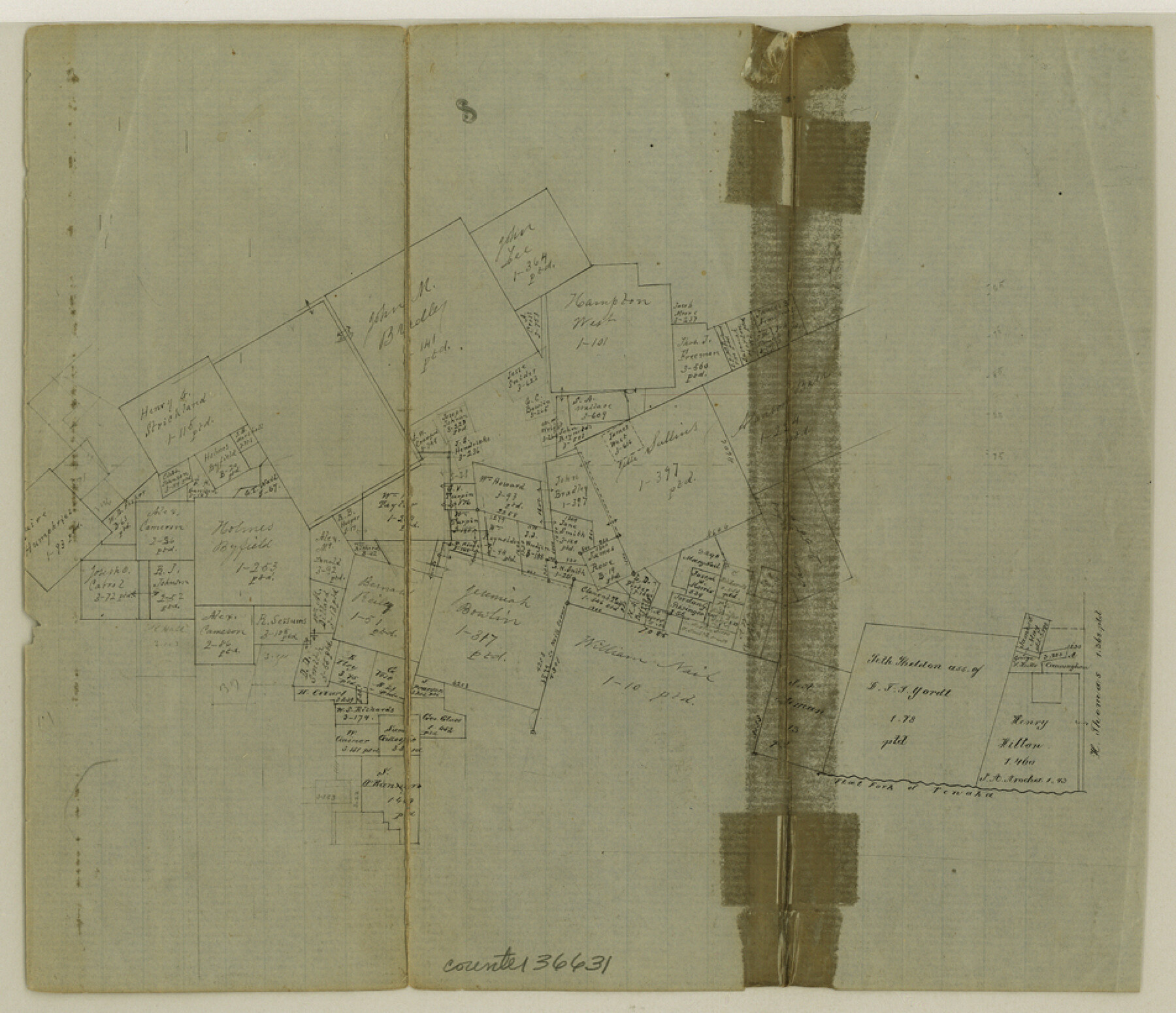
Shelby County Sketch File 17
[Three sketches all in the north part of the county north of Flat Fork Creek]
-
Map/Doc
36631
-
Collection
General Map Collection
-
Counties
Shelby Panola
-
Subjects
Surveying Sketch File
-
Height x Width
8.2 x 9.5 inches
20.8 x 24.1 cm
-
Medium
paper, manuscript
-
Features
Flat Fork of Tenaha Creek
Part of: General Map Collection
Castro County

Print $20.00
- Digital $50.00
Castro County
1932
Size 39.2 x 34.4 inches
Map/Doc 77234
Brazos River, Sketch Map of Imperial and Harlem State Prison Farms, Fort Bend County Texas Showing Tentative Plan of Reclamation

Print $20.00
- Digital $50.00
Brazos River, Sketch Map of Imperial and Harlem State Prison Farms, Fort Bend County Texas Showing Tentative Plan of Reclamation
1929
Size 25.6 x 25.6 inches
Map/Doc 69681
Red River County Working Sketch 81-4

Print $20.00
- Digital $50.00
Red River County Working Sketch 81-4
1987
Size 21.8 x 16.7 inches
Map/Doc 72067
Bee County Sketch File 14

Print $40.00
- Digital $50.00
Bee County Sketch File 14
1878
Size 14.5 x 12.5 inches
Map/Doc 14297
Terrell County Working Sketch 42

Print $20.00
- Digital $50.00
Terrell County Working Sketch 42
1957
Size 34.4 x 34.4 inches
Map/Doc 62135
Garza County Sketch File 23

Print $6.00
- Digital $50.00
Garza County Sketch File 23
1907
Size 11.3 x 8.7 inches
Map/Doc 24080
[Cotton Belt, St. Louis Southwestern Railway of Texas, Alignment through Smith County]
![64382, [Cotton Belt, St. Louis Southwestern Railway of Texas, Alignment through Smith County], General Map Collection](https://historictexasmaps.com/wmedia_w700/maps/64382.tif.jpg)
Print $20.00
- Digital $50.00
[Cotton Belt, St. Louis Southwestern Railway of Texas, Alignment through Smith County]
1903
Size 21.8 x 29.1 inches
Map/Doc 64382
Webb County Working Sketch 36

Print $40.00
- Digital $50.00
Webb County Working Sketch 36
1940
Size 38.4 x 67.3 inches
Map/Doc 72401
Cooke County Working Sketch 19

Print $20.00
- Digital $50.00
Cooke County Working Sketch 19
1954
Size 23.8 x 20.7 inches
Map/Doc 68256
Travis County

Print $40.00
- Digital $50.00
Travis County
1880
Size 61.7 x 24.0 inches
Map/Doc 87934
Jeff Davis County Rolled Sketch 27

Print $20.00
- Digital $50.00
Jeff Davis County Rolled Sketch 27
1969
Size 29.3 x 36.8 inches
Map/Doc 6375
El Paso County Sketch File 38

Print $4.00
- Digital $50.00
El Paso County Sketch File 38
1987
Size 14.3 x 8.9 inches
Map/Doc 22223
You may also like
Leon County Working Sketch 56

Print $20.00
- Digital $50.00
Leon County Working Sketch 56
1991
Size 32.7 x 26.4 inches
Map/Doc 70456
Dimmit County Sketch File 57

Print $6.00
- Digital $50.00
Dimmit County Sketch File 57
1941
Size 14.3 x 8.8 inches
Map/Doc 21190
Station Map, the Missouri, Kansas and Texas Ry. Of Texas - Henrietta Division

Print $20.00
- Digital $50.00
Station Map, the Missouri, Kansas and Texas Ry. Of Texas - Henrietta Division
1918
Size 11.9 x 26.9 inches
Map/Doc 64765
Zavala County Working Sketch 30

Print $20.00
- Digital $50.00
Zavala County Working Sketch 30
1989
Size 36.8 x 28.1 inches
Map/Doc 62105
Gregg County Sketch File 1C

Print $6.00
- Digital $50.00
Gregg County Sketch File 1C
1847
Size 7.8 x 11.6 inches
Map/Doc 24540
Parker County Working Sketch 9

Print $20.00
- Digital $50.00
Parker County Working Sketch 9
1958
Map/Doc 71459
University Lands Blocks 29-33, Crockett County, Texas

Print $20.00
- Digital $50.00
University Lands Blocks 29-33, Crockett County, Texas
1936
Size 29.2 x 42.4 inches
Map/Doc 2407
[State Line from Southeast New Mexico to Yoakum County]
![92013, [State Line from Southeast New Mexico to Yoakum County], Twichell Survey Records](https://historictexasmaps.com/wmedia_w700/maps/92013-1.tif.jpg)
Print $20.00
- Digital $50.00
[State Line from Southeast New Mexico to Yoakum County]
Size 32.3 x 11.7 inches
Map/Doc 92013
Rusk County Sketch File 13

Print $4.00
Rusk County Sketch File 13
Size 8.6 x 6.4 inches
Map/Doc 35514
Harris County Rolled Sketch 91

Print $407.00
- Digital $50.00
Harris County Rolled Sketch 91
1981
Size 31.0 x 24.3 inches
Map/Doc 6130
Titus County Working Sketch 5

Print $20.00
- Digital $50.00
Titus County Working Sketch 5
1962
Size 38.2 x 46.8 inches
Map/Doc 69366
Clay County Rolled Sketch 5

Print $20.00
- Digital $50.00
Clay County Rolled Sketch 5
Size 21.0 x 23.6 inches
Map/Doc 5499